
| No | Name | Description |
|---|---|---|
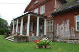 |
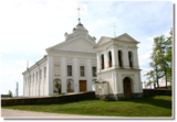
The mansion of Uue-Varbla Manor houses the local history museum which presents local life from the early 20th C and history of Varbla municipality. There is a handicraft workshop in the museum, while old tools and machinery are exhibited in the granary. The mansion in early Classicist style from 1797 is an attraction in itself. Traditional handicraft fairs are held in the grounds in July every summer. |
|
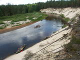 |
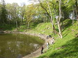
This comparatively large territory is found to the South of the Irbe River and Stende River, and it is unique with more or less virginal forests and dunes. The Irbe River has a system of ancient tributaries, and the Dižpurvs swamp is parallel to the shoreline. The Irbe has become a popular river for water tourism in recent years, but the tourist infrastructure on its banks remains insufficient. Territory has good road connections and has potential for nature education activities. |
|
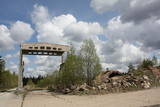 |
The ship and coast guard missile repair workshops in the forests around Bārta in the Liepāja District are very impressive in visual terms. The facility is owned by the regional local government and is being dismantled to obtain building materials.
|
|
 |
This craftsman uses the black ceramics technique. You can watch him opening the kiln, take part in creative workshops, and commission or purchase ceramics products. |
|
 |
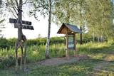
This village is at the place where the Irbe (Dižirve, Īra) River flows into the sea, and it is on both shores of the river (sea side and land side). The name of Irbe was recorded for the first time in a 1310 border agreement between the bishop of Kurzeme and the Rīga Dome Capitol. The name of Lielirbe (Irvemūnde) was recorded for the first time in a document from an arbitration court in 1387. At the end of the 19th century, the small port at Lielirbe was an active centre for the sale and transport of timber materials. In the late 19th and early 20th centuries, the largest number of sailing ships among villages on the western shore of Kurzeme was built there. In 1939, the village had some 300 residents, more than 70 houses and a Baptist church which is now at the Ventspils Open Air Museum. A narrow-gauge railroad passed through the village, which had a post and telegraph office, two grocery stores, an elementary school, a choir and a brass band. Lielirbe was one of the largest villages to disappear after World War II. Cultural historian Valda Marija Šuvcāne (1923-2007) was born in Lielirbe, and her daughter, Baiba Šuvcāne, is continuing her mother's work by writing important papers about life along the Livonian coastline. By 2019, a bridge is to be reinstalled across the Irbe River. |
|
 |
Atrodas Ganību ielā 120. Celta (iesvētīta 2001. g.) mūsdienu modernās arhitektūras formās un interesanta ar faktu, ka sākotnēji bijusi Vatikāna paviljons Pasaules izstādē “Expo 2000” Hannoverē. To pārbūvēja un uz Liepāju pārcēla par Vācijas katoļu saziedotajiem līdzekļiem. Ēkā darbojas katoļu draudzes centrs. |
|
 1 day
|
Dodieties ekskursijā, lai gūtu ieskatu lauku profesijā un dzīvesveidā, kā arī iegūtu jaunus iespaidus un labu atpūtu visai klasei. Ekskursijas laikā apmeklējiet mini zoo, kur apskatāmas aitas, kazas, Ķīnas lielās cūkas, truši, dažādi eksotiskie dzīvnieki un putni. Bērniem īpašu prieku sagādā saskarsme ar mājdzīvniekiem un Japānas makaka – pērtiķa Nilsona izdarības. Pēc tam apmeklējiet zemnieku saimniecību, kurā izveidots atrakciju parks ar vairāk kā 20 atrakcijām 3,5 hektāru platībā. Ekskursijas noslēgumā dodieties uz atpūtas kompleksu pašā Zemgales sirdī, lai apskatītu vējdzirnavas un izceptu paši savus pīrāgus. |
|
 |
The Bebrene Catholic Church is opposite the Bebrene Estate on the side of the Ilūkste-Birži road. Work on the church began in 1797, but it was only completed in 1883. The outside of the church is in the style of Classicism, while the interior was designed in Baroque forms. The interior of the church can be viewed during worship services. |
|
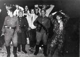 |
The Soviet Border Guard arrived at Lapmežciems (its border with Ragaciems) in the mid-1960s and left in 1991. Some 50 military personnel were stationed here. The military personnel and local residents organised various events and celebrations. The only thing that worried locals was a radar which was said to cause various problems. The zenith missiles were dismantled and taken away in 1991. An apartment building is still on what was then the military base. |
|
 |
15.janvāra naktī Kalpaka bataljons izcīnīja pirmo kauju pie Lielauces, atvairot sarkano uzbrukumu. Tā bija pirmā nozīmīgā Kalpaka bataljona kauja, kad uzvara karavīriem deva īpaši spēcīgu morālu stimulu. 1934. gada 19. augustā pie Lielauces luterāņu baznīcas atklāja pelēkā granītā veidoto pieminekli Oskara Kalpaka bataljona pirmās kaujas vietā. Piemiņas zīme veidota pēc arhitekta P. Dreimaņa meta. Lielauces kauja notika 1919. gada naktī no 15. uz 16. janvāri starp kalpakiešu Cēsu un Virsnieku rotu no vienas puses un 2. strēlnieku pulka karavīriem. 50. gadu sākumā piemineklis tika iznīcināts, bet atjaunots 1991. gadā |
|
 |
At the estuary of the Inčupe River, there is the White Dune, which is around 18 metres high and is the most lovely element of the Vidzeme shoreline among those that have been created by the wind, sand and sea. There is a wooden footpath (the Saulriets trail) which is meant to view, but also protect the dune. It has a viewing area, too. The territory to the south of the river is in the Piejūra Nature Park.
|
|
 |
Торговый канал, протяженностью неполных 3 км, в советское время являлся закрытой зоной со статусом режима приграничного района. Лиепайский порт был известен еще в XIV столетии. В конце XVII века здесь выкопали канал, который соединил море с Лиепайским озером - теперешний Торговый канал. Заканчивается он Зимним портом и двумя молами, из которых Южный мол служит излюбленным местом для прогулок и рыбалки. В южной части Торгового канала тянется Променад, на котором установлены Янтарные часы. |
|
 |
The “Kukaburra” café is located on the 115th km of the Riga-Veclaicene highway (A2). It is possible to see the Bread museum. Guests can take part in baking rye bread every weekend. The café has a Latvian interior and serves products from local farmers and home-based producers of ingredients. Latvian cuisine: Chicken liver salad, lamb soup, dumpling soup, cold soup, baked catfish, sautéed pork, potato pancakes, pancakes with jam cottage cheese buns, stacked rye bread. Special foods: Home baked rye bread. |
|
 |
The biggest sea island in Estonia. In translation - "Land of The Islands". A bridge, where cyclists can drive connects Saaremaa island to Muhu island . |
|
 |
The Līgatne Paper Factory is located at Pilsoņu Street 1 in Līgatne. The factory was first built in place of an old paper windmill by two tradesman from Rīga who also built dormitories for residents. These structures are an important component in the urban environment of Līgatne. The rapid flow of the Līgatne River allowed the factory to produce writing paper, stationary and wrapping paper. In 1858, the factory was brought by a local nobleman who brought in new equipment from Scotland. If some 100 people worked at the factory during the first half of the 19th century, then that number rose to 600 by the end of the century and 800 at the beginning of the 20th century. Writing paper was the primary product from the factory, although there were sometimes special orders. During World War I, for instance, the factory produced paper on which the Russian military printed its maps. This allowed the factory to hold an important role in the Russian market. During the Soviet era, the factory at Līgatne produced notebooks and other products that were sent all over the USSR. Today the factory mostly produces wrapping paper of various kinds from waste paper. The Līgatne Paper Factory is the only functioning entity of its kind in Latvia, and there are guides available to give you a tour. The historical centre of the campus on which the factory sits is a cultural monument. The Līgatne Tourism Information Centre (_371-6415-3313) offers tours of the centre during which you will learn about the lives of the factory's workers and administrators in the late 19th and early 20th century. Back then there was major construction work at the factory to build residences for workers, a school, a childbirth facility, a hospital, a club, a guesthouse and other buildings which have survived to the present day. |
|
 |
"Sabiles laivas" Talsu novadā piedāvā laivu nomu, laivu un laivotāju transportu. |
|
 |
Kokneses dabas taka (5,65 km) ved gar Daugavas un Pērses krastiem un savieno Kokneses parku un Likteņdārzu. Pastaigā pa dabas taku var doties no jebkuras sevis izvēlētas vietas, kas vijas cauri Kokneses parkam. Takā izveidotas laipas, tiltiņi, informācijas stendi un norādes. |
|
 12 days
|
The duration of the route is up to 12 days with self-drive transportation. The total distance is about 1 500 km.
|
|
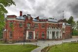 |
The construction of the state began in the early 20th century. The mansion was built of bricks and fieldstones between 1905 and 1911 in the styles of Historicism and Art Nouveau. The estate was owned by engineer and professor Stanislav Kerbedz from St Petersburg, the first Russian engineer to develop principles for the architectonic aspects of bridges. These were used during the latter half of the 19th century, and Kerbedz led the construction of the Nikolayev bridge across the Neva River in St Petersburg. Kerbedz’s wife, Yevgenia, was well known as a lover of art, and she brought various art objects to the estate from Italy. The Lūznava Estate was a popular place for gatherings of artists during the summers. Among those to visit was the distinguished Lithuanian painter and composer Mikalojus Čiurlionis. The estate is surrounded by a 23.7 ha landscape park with a system of ponds. Near the estate is a statue of the Madonna, which was carved by an unknown Italian artist. The statue was damaged and thrown into a pond during World War II, but it was restored in 1991. Reconstruction of the main building of the estate was complete in 2015, and today it is a modern and international centre for environmental education and the arts. |
|
 |
The Ķemeri water tower was built in 1929
and used to be a reservoir for drinking and
mineral water. Until World War II, there was a
viewing platform at a height of 42 metres from
which one could see the surroundings of
Ķemeri.
|
|


