
| No | Name | Description |
|---|---|---|
 |
Pie Melekiem sākas dabas lieguma teritorija. Meleku
krastmala būtiski mainījās 2005. g. orkāna laikā.
|
|
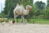 |
A park of exotic animals in Dundaga features alpacas, llamas, ostriches, a camel, a blue cow, etc. |
|
 |
Der älteste und größte Kurort Litauens (seit 1794). Mikroklima (Luft der Umgebungswälder), salzhaltigee Quellen, Heilschlamm. Die Altstadt ist ein städtebauliches Denkmal. |
|
 |
This territory in the northern part of the Dzūkija Highlands with lots of hillocks and lakes. The most interesting tourist destination is Velnio duobė (Devil’s Flowerbed) – a funnel-shaped hole that is up to 40 m deep and 200 m wide and is thought to have originated during the Ice Age.
|
|
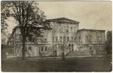 |
Muižas ansamblis veidots 19.gadsimtā, tās arhitektūrā atspoguļojās vairāku eklektisma formāli stilistisku virzienu uzslāņojumi, taču dominējošais bija baroka stils. Tā bija grāfa Kazimira Plātera-Zīberga (1808-1876), vēlāk grāfa Fēliksa Konstantina Plātera-Zīberga (1847-1928) rezidence. Pils un daļa saimniecības ēku tika iznīcinātas pirmā pasaules kara laikā, krievu armijas lielkalibra artilērijas apšaudes gaitā. Pārpalikušās drupas laika gaitā tika nojauktas. Līdz mūsdienām saglabājušies vārtu stabi, kas ir apmierinošā tehniskā stāvoklī. Muižā bijusi arī grāfa Zīberga 1697. gadā celta mūra kapela ar altāri un skaistām gleznām. Dievkalpojumus esot noturējis Ilūkstes prāvests. Bijušie īpašnieki: 18. gadsimtā barons A. Plāters-Zībergs, Kazimirs Plāters-Zībergs (1808-1876).
|
|
 |
Taka ved cauri mežam uz skatu torni purva malā. Takā apskatāma Nāzara priede –priede, pie kuras 1905. gadā nošauts dumpinieks, pati priede – ekoloģiskais koks ar dzilnu kaltiem dobumiem, nokaltusi. Melnalkšņu dumbrājs - slīkšņa ar cūkaušiem un puplakšiem. Oleru purvs no skatu torņa – pārejas un sūnu purvs, kas izveidojies nolaista ezera vietā. Papildus objekti blakus takai, pieejami pa ceļu – Oleru muižas komplekss, Krustakmens, Oleru muižas kapi. Kopējais takas garums: 1,1 km. |
|
 |
This extensive territory to the South of Pāvilosta once was the site of warehouses and an oil base. The territory at this time is used for the extraction of raw materials. There is also a sawmill there. The sign at the entrance of the facility states that the area can be dangerous to visitors.
|
|
 |
Vecpiebalgas vecajos kapos (Vecpiebalgas austrumdaļā, pa ceļam uz "Saulrietiem" un "Vēveriem") apskatāms piemineklis, kas veltīts brāļu Kaudzīšu romāna "Mērnieku laiki" personāžam - Lienai. Piemineklis uzstādīts 1987. g. (tēlniece M. Baltiņa). Pirms ceļojuma atkal ir jāpāršķirsta "Mērnieku laiki"! |
|
 |
The Sunset trail starts in the centre of Saulkrasti town and takes you to the White Dune. Saulkrasti town with its municipal rural territory, occupies a 17km long stretch of coastal land to the North from the river Lilaste and the lake Lilaste. The White Dune stands on the right side of river Inčupe mouth. It is covered by old pine forest. The white, 18m high sand outcrop in olden times served as a landmark for fishermen. The White Dune formed as winds carried the sand from the beach over clay sediments of the Baltic Ice Lake. Some 150-200 years ago, the dune had been drifting as witnessed by several layers of soil buried within it. Local fishermen and farmers at Bātciems initiated afforestation of the drifting dunes. At that time, the 30m high dunes which are now covered with forest, were bare, shifting and even buried a farmstead. To speed up afforestation, mountain pines were planted. The White Dune was partly washed away in heavy storm in 1969, and 4-6m high precipice formed. Now the wind and sand have levelled out the dune surface, it has been fixed with willow-twigs or grown with forest where the largest pines are more than 170-190 years old. The pines are notable with their large trunks and branches, the scars obtained during their lifetime and the typical “crocodile skin” – the bark forms rhombuses resembling those of the reptile’s scales. Scots Pine (Pinus Silvestris) is one of the most common tree species in Latvia. It grows in dry, meagre sandy soil in dunes as well as in marsh. However, it does not stand overshadowing. Forest fires help pines to get rid of competitors as pine endures fire better than other trees because of its thick bark and high crown. The wood exudes resin and burned wounds close soon. Fire cleans space for seedlings of young pines. Pines can live 300-350 years. Ground cover in dune forests is very sensitive. If the sparse vegetation is destroyed, not only the natural biodiversity and landscape is damaged, but also the dangerous shifting dunes can possibly “wake up”. Embryonic dunes, White (yellow) dunes, Grey dunes and Wooded dunes are EU protected biotopes. Grey Dunes are protected by Latvian law as well. |
|
 |
Ein ehemaliges Fischerdorf am Ufer des Kurischen Haffs. Hierher sind die Bewohner der Dörfern umgezogen, deren Dörfe unter dem Sand der Wanderdünen begraben wurden. Holzbebauung des 19 – 20 Jh. |
|
 |
The holiday houses are located near Lake Ieva, 30 m from the lake shore. On the 1st floor of the holiday house - lounge with fireplace and glazed veranda, sauna (50.00 EUR / evening), small kitchenette, toilet. Outside-small terrace overlooking the lake. On the 2nd floor there are 2 isolated rooms and 10 beds. By the lake - a fireplace, a well-groomed swimming area with a footbridge. Boats and catamarans can be rented. |
|
 |
The estate in Milzkalne that is along the banks of the Slocene River dates back to the 15th century, when it was built as a closed complex for the Livonian Order. It is the only fortified estate of its type to have survived to the present day, and it was once used as a hiding place for aristocrats during an attack. The gate towers with their ornate weather vanes were built in the late 17th century, and the ancillary buildings date back to the 18th and 19th century. A brick wall with firing apertures survives. The Latvian Road Museum is in one of the wings of the complex, while the former mansion offers accommodations, tours and tastings of local goodies. |
|
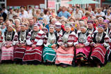 |
Setomaa in South-East Estonia is a unique area for its people (the Seto) and culture. The historic location in the borderland between East and West, straddling two languages and cultures has shaped the local language, life style, clothes and food. A very specific type of singing – leelo – is incorporated in the UNESCO list of Masterpieces of the Oral and Intangible Heritage of Humanity. |
|
 |
Divstāvīgs skatu tornis pie Laikjula (Laiküla) – Hāpsalu ceļa, no kuras paveras plaša ainava uz Matsalu līcī ietekošo upīšu palieņu pļavām. Te var vērot migrējošās dzērves un zosis, bet pavasaros varbūt laimēsies redzēt vai dzirdēt ķikutu Gallinago media. Viens no retajiem torņiem, kas ir pielāgots cilvēkiem ar īpašām vajadzībām. |
|
 |
The owner has a collection of some 2,000 spoons which he has carved from 70 types of wood from trees and bushes during more than 30 years. The smallest spoon is made of osier, while the largest one, “A European Spoon,” is larger than the height of a human being. The artist also produces paintings made of wood. You can watch him at work, purchase the spoons, and tour his museum. |
|
 |
Bioloģiskā saimniecība nodarbojas ar Irbeņu ogu audzēšanu un dažādu to produktu ražošanā kā pulverus, sulas, tinktūras, eļļas, sejas maskas un kapsulas. Irbene ir vērtīgs ārstniecības augs, kur izmantojamas ir pilnīgi visas tā daļas – lapas, ogas, sēklas, stumbrs, miza, sakne un ziedi. |
|
 7 days
|
This long tour of Latvia includes some of the best and most beautiful parts of Jūrtaka in Latvia. Hikes along the sea alternate with trips and excursions in the cities. You will go along the coast of the Baltic Sea from Mazirbe to Kolka, seeing Slītere National Park and Livonian villages. You will see Engure Nature Park and the overgrown seaside meadows that are suitable for bird watching. Along the way, you will be able to purchase smoked fish from local fishermen and learn about fishing traditions in Latvia. Further, the route will take you through the most popular seaside resort in Latvia, Jūrmala; you will also have time to visit the capital city - Rīga. The second part of the route runs along the Vidzeme coast from Saulkrasti to Svētciems. In terms of landscapes and views, the most multifaceted section of the Baltic Coastal Hiking Route in Latvia, which includes both sandy and rocky beach, coastal meadows, reeds, dunes, sandstone outcrops, forests, capes and small coves, fishing villages and pubs. |
|
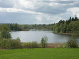 |
This restricted area protects the eutrophic Lake Istra and the biotopes that are alongside it – various kinds of forests and meadows. This is a particularly lovely part of the Latgale region. Interestingly, the so-called system of “rope farms” can still be seen in the nature park.
|
|
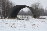 |
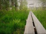
Few Soviet military objects are associated with more legends than this one. During Soviet times, this was a reserve airfield, as well as a storage site (just 50 kilometres from the republic’s capital city) for nuclear weapons. These were hidden in two cement hangars that were covered with soil and vegetation. Public information suggests that an RX-24 nuclear bomb weighing 430 kg and a RX-26 nuclear bomb weighing 1,030 kg were stored here, as were air-to-land missiles equipped with nuclear explosives. If there had been an accident here, what would have happened to Rīga, to Latvia, to the Baltic States and to Northern Europe? The airfield is a closed territory today.
|
|
 |
The word “Luitemaa” means “land of the dunes” in Estoninan. This coastline territory stretches for 13 km between Vöiste and Häädemeste with shallow waters, large coastal plains, Estonia’s highest dunes, and the Tokuse swamp (Tokuse raba). There are lots of birds here.
|
|


