
| No | Name | Description |
|---|---|---|
 |
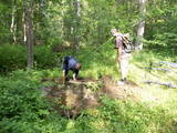
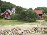
Saimnieki piedāvā vietu, kur aizbraukt brīvā laika pavadīšanai, atpūtā ģimenei Kurzemē. Šeit viesiem ir iespēja aplūkot sākot no dažādu laiku lauksaimniecības tehnikas un darbarīkiem, līdz pat kara laika paliekām, kā arī dažādu laiku sadzīviskos priekšmetus. Katram priekšmetam seko arī stāsti, kas ir piedzīvoti vai tikai dzirdēti. Tāpat apmeklētājiem ir iespēja apskatīt mājas iemītniekus,kas ir veidoti ar pašu rokām. Asākām un patīkamākām sajūtām pieejama 350 metrus gara Baskāju taka. |
|
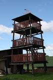 |
This is an interesting viewing tower which is part of one of the farm buildings. It offers a lovely view of the surrounding area.
|
|
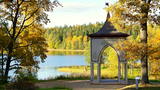 |
This landscape park dates back to the latter half of the 18th century, and its initiator was the owner of the Alūksne Estate, Baron Otto Hermann von Fittinghof. The largest park has important small buildings – the Alexander Pavilion, a temple honouring the Ancient Greek god of winds, Aeolus, the Palm House, a 1799 granite obelisk, the mausoleum for the noble family, a fountain basin that is made of a single piece of granite, as well as a set of granite benches. This is known as one of the most beautiful parks in Vidzeme. |
|
 |
The ancient Dviete river valley information centre “Gulbji” is one of the most important information facilities in the nature park and is housed in a single family farm that is 100 years old and is typical of the historical region of Selonia. Visitors can study an exhibition that is dedicated to the park, buy products from local craftspeople and farmers, and enjoy a beverage that is made from the distillation of beaver glands. To the North and East of “Gulbji” is the Putnu island paddock (250 ha) with livestock adapted to life in the wild – Konik horses and Highlander cows. There’s a bird watching tower on the shore of Lake Skuķi, which is 500 m away. |
|
 |
The Vilciņi farm is one of the largest and most modern agricultural manufacturing companies in Zemgale, always using environmentally friendly methods. The farm is in the Krimūni Parish in the heart of the historical region of Zemgale. It was established in 1991 by the parents of the current owner, Arnis Burmistrs. Today the farm specialises in grain farming on ~2,200 ha of land. The farm uses precise agricultural methods to save money and preserve the environment and human health. It is actively involved in EU-financed projects, has a modern set of agricultural equipment, and has installed a local meteorological facility. Tours are available. |
|
|
|
Atrodas Sedas purvā (Sedas dabas takas malā) ar plašu skatu uz izstrādātajām kūdras platībām. Sedas taku ieteicams izstaigāt vietējā gida pavadībā T: + 371 2636162. |
|
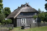 |
Koņuciems of Pape is one of the few seashore fishing villages in Latvia to have preserved an authentic environment to the present day. The Latvian Open-Air Ethnographic Museum has a branch here, “Vītolnieki”, and this is an authentic and ancient fisherman’s farm. +371-2926-2283. The sad fact is that some people have built modern buildings in the village, and it has now lost its earlier untouched charm. |
|
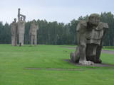 |
A Nazi concentration camp was at this location during World War II, and there is information to suggest that more than 50,000 residents of occupied Europe were murdered here. This is one of the largest ensembles of its type, taking up 25 hectares of land. It was opened in 1967 and has large groups of sculptures, including “Mother,” “Solidarity,” “Unbroken One” and “The Path of Suffering.” The wall of the entrance gates has a thematic exhibitions. |
|
 |
The remnants of the Vardīte sulphurous
spring – not easy to find, but the location is
between the Forest House and the Ķemeri
Hotel.
|
|
 |
15.janvāra naktī Kalpaka bataljons izcīnīja pirmo kauju pie Lielauces, atvairot sarkano uzbrukumu. Tā bija pirmā nozīmīgā Kalpaka bataljona kauja, kad uzvara karavīriem deva īpaši spēcīgu morālu stimulu. 1934. gada 19. augustā pie Lielauces luterāņu baznīcas atklāja pelēkā granītā veidoto pieminekli Oskara Kalpaka bataljona pirmās kaujas vietā. Piemiņas zīme veidota pēc arhitekta P. Dreimaņa meta. Lielauces kauja notika 1919. gada naktī no 15. uz 16. janvāri starp kalpakiešu Cēsu un Virsnieku rotu no vienas puses un 2. strēlnieku pulka karavīriem. 50. gadu sākumā piemineklis tika iznīcināts, bet atjaunots 1991. gadā |
|
 |
There are three craters here, and the biggest one, known locally as Põrguhaud, or Grave of Hell, has a diameter of 80 m and a depth of up to 12 m. There are barriers around the crater that are several metres high. The other two craters are hard to spot. The craters around 6,000 years old. No scraps of the supposed meteorite have been found, however, and so the origins of the craters cannot be confirmed with certainty.
|
|
 |
This is the most impressive and colourful set of cliffs along the Vidzeme coastline. Waves have created the steep shore that is as much as 6 m high, with several hundred meters of red sandstone cliffs with narrow caves, niches, grottos and other formations. The nearby Veczemu farm is where the Rīga Film Studio shot the films “Long Way into the Dunes” and “The Nest of the Old Fisherman.”
|
|
 |
Hiiu Vill is a family business and one of very few wool manufacturing companies in Estonia, it uses 19th C machinery of Polish origin (carding and roving machines), which the owners are happy to demonstrate. A café is open in summer only; woollen handicrafts are sold all year round. |
|
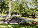 |
Parkā blakus pusloka tiltiņam ir novietotas trīs milzīgas dzelzs atslēgas, kuras balsta akmens mūris un metāla arkas. Tās simbolizē trīs vēsturiskos centrus un to vienotību – Siguldu, Turaidu, Krimuldu. Dobēs pie šī objekta sezonāli zied dažādi kultūraugi. |
|
 |
Ein ehemaliges Fischerdorf am Ufer des Kurischen Haffs. Hierher sind die Bewohner der Dörfern umgezogen, deren Dörfe unter dem Sand der Wanderdünen begraben wurden. Holzbebauung des 19 – 20 Jh. |
|
 |
The Staburags cliff of Rauna has been Latvia’s most distinct travertine cliff since the great Staburags cliff of the Daugava River sank under the waves during the construction of a hydroelectric power plant nearby. The cliff is approximately 8,000 years old and is still being formed as lime settles on moss and other plants. The Staburags cliff of Rauna is cited as the only location in Latvia of the Alpine butterwort, but it has not been seen there for the last 15 years. That is probably because of the many people who tramp across the cliff each year. The streams which deliver lime to the cliff are a biotope that is of priority at the EU level.
|
|
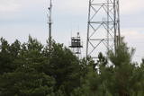 |
The military communications facilities at Pāvilosta are along the southern part of the town. The facilities are owned by the local government, and there is no information about their use at this time.
|
|
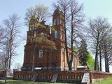 |
Sts. Simon and Judas the Apostles Roman Catholic Church of
Prezma. The brick stone church with its two towers was built in 1859.
The Monument of National significance.
|
|
 |
Territory is not attractive for a visitor without environmental knowledge and is very hard to find and reach through swampy forests on the North from Riva village. Area is not intended and appropriate for visits.
|
|
 |
The area is in the centre of the Teirumnīki swamp, alongside a lake of the same name. There is a wooden footpath that crosses the swamp (800 metres). This is an excellent opportunity to study a high swamp, a swamp lake, and the surrounding environment.
|
|


