
| No | Name | Description |
|---|---|---|
 |
The only island in Lake Ciecere has a more or less virgin forest of oak, linden and elm. Some of the oaks are huge. This is an important habitat for woodpecker-type birds. The island has not been improved. |
|
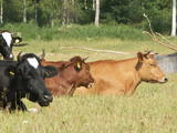 |
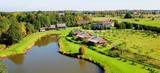
The farm grows peas, grits and beans, and it breeds cattle. Visitors can take a tour to learn about biodynamic agricultural techniques. |
|
 7 days
|
This long tour of Latvia includes some of the best and most beautiful parts of Jūrtaka in Latvia. Hikes along the sea alternate with trips and excursions in the cities. You will go along the coast of the Baltic Sea from Mazirbe to Kolka, seeing Slītere National Park and Livonian villages. You will see Engure Nature Park and the overgrown seaside meadows that are suitable for bird watching. Along the way, you will be able to purchase smoked fish from local fishermen and learn about fishing traditions in Latvia. Further, the route will take you through the most popular seaside resort in Latvia, Jūrmala; you will also have time to visit the capital city - Rīga. The second part of the route runs along the Vidzeme coast from Saulkrasti to Svētciems. In terms of landscapes and views, the most multifaceted section of the Baltic Coastal Hiking Route in Latvia, which includes both sandy and rocky beach, coastal meadows, reeds, dunes, sandstone outcrops, forests, capes and small coves, fishing villages and pubs. |
|
 3 days
|
This trip will allow you to visit a farm in Kurzeme and to experience the diversity of its output. Tasty and interesting! From Rīga, the road will lead you along the Gulf of Riga and through fishing villages which are full of the aroma of smoked fish. On the way to Talsi, you will visit an orchard and farm that produces apple chips. Talsi is known not just as the town on nine hills, but also as the home of the tasty "Talsi Wheel" brand of cheese. Also here is the Latvian Agriculture Museum with an exhibition about farming from the late 19th century to the present day. The symbol of Kuldīga is a red brick bridge across the Venta River, as well as the charming Old Town. Next you will visit the seashore to learn about fishing, fish smoking and bread baking traditions. Visit the unique steep shores of Jūrkalne. On the way back you will visit a winemaking facility and a farm where shiitake mushrooms are grown. You will also learn about the path of milk from a cow to finished dairy products and visit a farm at which people will tell you about the story of their family which dates back to the age of noblemen and baronial estate. |
|
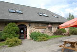 |
This saloon is located 5 km from Madona and at the edge of a highway in the forests of Smecere – the 37th kilometre of the Pļaviņas-Gulbene road. The building in which the saloon is housed was built in the 17th century, and today it is home to a modern leisure complex made up of a three-star hotel, a saloon and cafe, and a music club. |
|
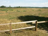 |
Periodically flooded flood-land meadows on the eastern and southern shores of Lake Burtnieks are an important nesting location for the rarely seen corncrake. A nature and information trail has been established at Vīsrags with directions, information stands and a viewing tower.
|
|
 |
Lovely café, located in the old folk house; here you can buy unique cheeses, dumplings, chanterelle-bean-pear barley soup, vadsas, meadow-sweet syrup drink. |
|
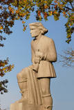 |
Another monument designed by Kārlis Zemdega, this one was installed in 1937 and was initially known as a monument to soldiers who liberated and fell in Rūjiena. The monument survived the Soviet era only because a statue of Lenin that was across the street was on a high pedestal and thus overshadowed the monument to the trumpeter of Talava. |
|
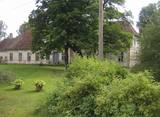 |
The historical centre of the Tāšu Estate is in the Ālande (Telse) River Valley near Lake Tāši. The current estate was built by the von Korff dynasty, and the mansion dates back to 1734. Inside there are valuable Baroque fireplaces, the main entrance portal made of sandstone from Gotland, the original stone floor in the hall, parquet and wall panels. The front door, windows, stairs and other details were installed in the early 19th century |
|
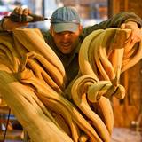 |
The master craftsman uses natural wood to produce furniture and interior design elements. He uses the tree from the tip to the root. Each artwork accents the form and texture of the wood, and the workshop offers an unusual look at wood and people. You can attend educational events and commission and purchase gifts and souvenirs. |
|
|
|
Ļoļi Devil’s Footprint is situated in Mākoņkalns rural territory in a small forest lawn several meters from the
ditch, which is a borderline of the Rēzekne and Krāslava districts. It is about 1,9 m high truncated cone, the base
perimeter 1,8 m. According to the legend, the boulder had a curvy of the horseshoe prints. Now it’s shapeless. For the
first time the stone as a geological monument was established in the 1930s. It was in Andrupene rural territory.
|
|
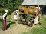 |
The 11 buildings of the museum feature farm equipment, horse-related equipment, several dozen internal combustion motors, as well as tools used by craftspeople and farmers during Latvia’s first period of independence. The annual harvest festival brings together as many as 2,000 visitors. A harvest festival features special porridge. Groups can take part in a bread programme, watching the production of bread from dough to loaf. |
|
 |
The Strūves Park is toward the northwest of Jēkabpils, on the left bank of the Daugava, and opposite the Ādamsona (Krustpils) island. The park was established in the 19th century as a place where the city’s residents could relax and hold celebrations. It can be said with absolute certainty that this is a place of global importance, because the park contains a memorial stone to Professor Friedrich Georg Wilhelm Struwe (1793-1864) from the University of Tartu. He was an astronomer and geodesist. The stone is at a place where Struwe completed his land survey of the Vidzeme Province of the Russian Empire. The meridian location which Struwe identified (and other points related to those locations are found in many other European countries) is on the UNESCO list of world heritage. |
|
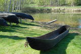 |
The Vienkoči Park features one-log objects manufactured by its originator. You can examine mock-ups of the Nurmiži Castle and other buildings including the Sand House, and you can also take part in thematic events. Men can produce equipment to drain birch juice from trees, wile women can try their hand at jewellery making from natural materials. People manufactured one-log objects during the Mesolithic Era, and one-log boats have been used since the 9th century (several of them can be seen at the park). |
|
 |
Saimniecībā tiek piedāvāti dažādi biškopības produkti: medus, bišu maize, propoliss, vaska sveces. Iespēja sarunāt izzinošu ekskursiju - ceļojums bišu pasaulē ar gulēšanu uz bitēm. Tiek piedāvāta arī loku šaušana un zāļu tējas. |
|
|
|
Together with Valga on Estonian side - a peculiar frontier twin town. |
|
 |
The so-called Comet Fort was built on the Left Bank of the Daugava at its mouth, not far from the present Daugavgrīva lighthouse. It was built around the same time as the other forts of Mangaļsala (around 1808, although some sources say 1788). There were four Kane-type 152-mm cannons. The defensive batteries at Komētforts and Mangaļsala repelled a British naval attack in the Daugava estuary in 1855. It has to be added that Komētforts is a cultural monument of local importance. If we go along the shore of the sea from the Daugavgrīva nature reserve toward the Daugavgrīva lighthouse and scale the frontal dunes (without going past the sign which says “Closed Territory. Border Zone.”), then we can see the positions of the cannons, as well as underground cellars where munitions were once stored. The territory starts approximately 500 metres before the Daugavgrīva lighthouse and stretches to the lighthouse itself. During Soviet times, the territory was closed to civilians, because many secret military objects were in this area and in Bolderāja.
|
|
 |
This lovely territory includes the hillocks of Embūte, which are in the ancient Embūte valley. The aim of establishing the park was to protect the landscape, biotopes and species of the region. An ecological tourism trail has been established in the valley, as has a forest trail through the nature park (accessibly only in the company of a guide). Visitors will learn about the hillocks and ravines left behind by the Ice Age. The ravines and the forests along their sides are protected biotopes. There are also important natural and cultural monuments, including the Embūte castle hill and the ruins of a baronial estate, castle and church. Other points of interest include the death place of the Courlandian warrior Indulis, the Joda dam, meadows, a viewing tower, etc. Three unmarked bicycle trails are in the area. |
|
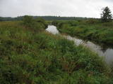 |
Palieņu pļavas starp Rūjienu un Rūjas ieteku Burtnieku ezerā, kurām raksturīga liela augu un putnu sugu daudzveidība. Tās robežojas ar bijušiem Rūjas zivju dīķiem, kas šobrīd aizaug ar mežu. Rūjas palienes var vērot gan braucot ar laivu pa Rūju, gan arī no ceļa, kas ved uz minētajiem dīķiem. Tur izvietots informācijas stends.
|
|
 |
The "Agluona" guesthouse offers coffee and dishes from Little Lithuania and Žemaitija. Tastings are offered of locally baked bread and Little Lithuanian pierogi and waffles. |
|


