
| No | Name | Description |
|---|---|---|
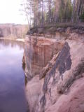 |
These sandstone cliffs were once known as the Pieškalni or Pieškaļi cliffs. They are around 7 km to the North from the centre of Cēsis. These are the most monolithic sandstone cliffs in the Baltic States – around 700 m long (with some 330 m along the Gauja River) and a maximum height of 22 m. There is a viewing area which offers a grand view of the Gauja River valley. Water tourists will boat up to the majestic wall of the cliff and will be surprised at what they see! The name of the cliffs, Ērģeles, is the word for "pipe organ" in Latvian, and the name was supposedly given to the cliffs because of the echoes which can be heard there – they reputedly sound like an organ. Hikers and boaters must be very careful when in this area – please make sure that you are safe! Please note, too, that the infrastructure of the cliff is scheduled to be renovated in 2012. |
|
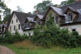 |
Ļoti savdabīga vieta, ko nekādi nevar dēvēt par tūrisma objektu. Vidsmuiža bija viena no Latgales lielākajām muižām, kuras dominante bija 18. gs. celtā un vēlāk pārbūvētā grāfu Borhu muižas kungu māja. Tagad redzamais muižas kompleksa veidols tapis 19. gs. otrajā pusē. Tajā ietilpst kūtis, staļļi, kalpu māja, klētis, sarga mājiņas, kas izvietotas ap parādes pagalmu. Pēdējais tagad ir stipri aizaudzis. Vecākā saimniecības ēka ir mūra klēts (iespaidīga!), ko cēla 18. gs. Regulāra plānojuma muižas parku veidoja 18. gs. franču dārzu stilā. Kungu māja ir „pamesta” un apskatāma tikai no ārpuses. |
|
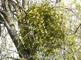 |
This is a mostly forested territory which is home to one of the largest areas of the white mistletoe, which is a semi-parasitic plant. It is best to observe this unique plant when it has no leaves. Latvia is the northern limit to the white mistletoe, which is why it is not all that common. It is interesting that even more of this rare specie can be seen outside of the nature restricted area. |
|
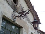 |
The craftsman produces practical and household items on the basis of Latvian ethnography, also continuing old traditions related to Latvian blacksmith operations. You can forge your own nail or horseshoe. |
|
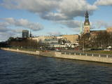 |
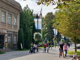
The classical skyline of Old Rīga can be enjoyed from several locations – Mūkusalas Street, between the railroad bridge and the stone bridge, from the stone bridge, from the A-B dam, from the grounds of the central office of the Swedbank bank, from the Vanšu bridge, and from the Ballast Dam at Ķīpsala. You can hike or bike from location to location. During the summer, little ships cruise up and down the Daugava to offer different views.
|
|
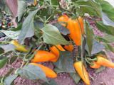 |
This farm produces raspberries (6 ha), herbs, medicinal plants (more than 100 types), vegetables (red peppers, cucumbers, tomatoes, chili peppers, onions, garlic) and bees. The owner produces salads, jams, lecho and chutneys. You can purchase vegetable products, pick your own raspberries and strawberries, taste teas, buy honey, and receive valuable consultations. |
|
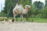 |
A park of exotic animals in Dundaga features alpacas, llamas, ostriches, a camel, a blue cow, etc. |
|
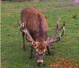 |
he wetland meadows that are around the Pededze River are the site of this 200 ha farm with some 350 red deer, other deer and wild boar. There are towers from which you can watch the graceful animals, and there are ponds for commercial fishing. Please contact the owner well in advance for a tour. |
|
 |
Materials of archaeological excavations show that the Ogre river banks were inhabited by the Livs. Ogre as a larger populated area and a major resort developed after the construction of Riga-Daugavpils railway in 1861. Until the World War I about 300 cottages offered their services in Ogre, most of them were destroyed during the war. The next "major" event took place 1965 when one of the largest knitwear plants in Europe was built in Ogre, which was staffed by guest workers from Vietnam and countries. Today, Ogre has still not recovered its glory of a resort, but has become a rather exclusive site of mostly low-rise residential buildings. |
|
 |
Atrodas Celtnieku un Z. Mauriņas ielu krustojumā. Dievnams uzcelts 2000. gadā modernās arhitektūras formās (arhitekti Aija un Andris Kokini), kas simbolizē Noasa šķirstu vai zviedru laivas, kas atnesušas kristīgo ticību. |
|
 |
This farm offers education about animals who live there, how they are bred and what the origins of their breeds are. You can gather eggs, learn to sit on a saddle and ride horses. The farm has Aberdeen Angus cattle, alpacas, various birds, horses, ponies, rabbits and goats. |
|
 |
Located at Daugavas Street 58 in Skrīveri, this was the first home of the Andrejs Upītis (1877-1970). It was built in 1908, but the one that is there now was built on the foundations of the first one in 1921. The building houses a museum which features the life and work of the writer, including the writing his great novel “The Green Earth.” There is a garden around the building. In 1952, Upītis gifted the house and garden to the state. The museum offers tours and educational programmes. |
|
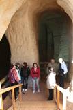 |
The area of the ancient Piusa River valley that is between the villages of Vana-Vastseliina and Ignasõ is around 15 km long, features some substantial rapids, and offers a view of beautiful Devonian period cliffs. The largest, Härma müür, is 43 metres high and is the highest sandstone cliff in Estonia. There are caves from old mines in the village of Piusa. A small part of the mines, which have tunnels that are more than 10 km long in all, has been tured into a local museum.
|
|
 |
This park was established to protect Lithuania’s longest lake, Lake Asveja (> 20 km). The lake is in a sub-glacial valley carved out by ice during the Ice Age, and it actually resembles a wide and curvy river.
|
|
 14 days
|
A panoramic tour of Lithuania and Latvia with highlights of nature experiences in the National parks and nature reserves. A variety of landscapes, nature attraction sites, birds and wild animals, forests and seashore. The tour also offers some cultural and historical insights. Baltic States are lucky to have plenty of untouched natural territories. During the Cambrian, Silurian and Devonian eras, the territory of the current Baltic States was often covered by seawater, which is why there are places where lots of geological evidence can be found about these periods in history. These are manifested not just in fossils and various geological objects, but also in the unique landscape. For example, The Gauja River basin is an outstanding locations for Devonian cliffs and caves. Other interesting elements of the terrain relate to the development of the Baltic Sea in the past – the Baltic Ice Sea and the Littorine Sea. That is well presented at he landscape of hillocks and valleys in the Slītere National Park. Many forests and bogs have remained virtually untouched as biotopes here. The Ķemeri, Slītere national parks were all established to protect wetlands. Rivers in the Baltic States have not been straightened and dense areas of buildings are not common. There are two “lands of lakes” in the Baltic States – Latgale and Augštaitija. The Baltic States are at the crossroads of the living areas of many different plants and animals, and that is why “northern,” “southern,” “western” and “eastern” species can all be found here. Some national parks have been established to protect distinctive local cultural heritage. |
|
 |
A family restaurant, located 12 km from Talsi, that offers traditional Latvian cuisine. |
|
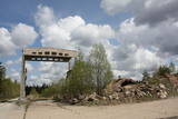 |
The ship and coast guard missile repair workshops in the forests around Bārta in the Liepāja District are very impressive in visual terms. The facility is owned by the regional local government and is being dismantled to obtain building materials.
|
|
 |
Litorīnas jūras laikā (pirms ~ 6000 gadiem) Saleveres Salumegi kalns bija sala, bet mūsdienās tas kā izteikta kāple (īpaši - ziemeļu pusē) paceļas virs Piejūras līdzenuma. Salumegi ziemeļu pusē slejas 4 - 5 metrus augsts kaļķakmens atsegums – silūra perioda (> 400 mlj. gadu) koraļļu rifa paliekas, kuru noskalojuši Litorīnas jūras viļņi. Atseguma piekājē izplūst Acu avots, kam piedēvē dziednieciskas īpašības. Salumegi apskates nolūkos izveidota lokveida taka (1,5 km). No kalna augšas paveras labs skats uz Matsalu līci. Šeit atradies arī sens pilskalns. |
|
|
|
Tahkuna lighthouse is on Tahkuna peninsula in the north of the island. It was built from French cast iron parts in 1875 and is the highest in Estonia at 43 m above sea level. |
|
 |
Größe Steinkreisen. In der Mitte befindet sich eine oder mehrere „Steinkapseln” für einen Verstorbenen. Wurden im Eisen- und Bronzealter errichtet. |
|


