
| No | Name | Description |
|---|---|---|
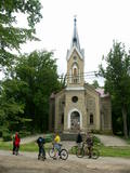 |
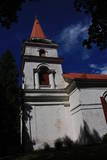
18 A. Upīša Street. The church was built in 1897 in the Neo-Gothic style (Architect H. Shel) and it is one of the few19th century city brick buildings. In the church there is the altarpiece "Christ healing the sick" - I. Zeberliņš (1943). You can see the church from the inside during the worship or by a prior arrangement. Near the church, you can see a monument designed by E. Laube (1926) to 80 Latvian riflemen who died in World War I and who were buried in the Warrior's Cemetery near the river Vēršupīte. Near the cemetery, there are also buried J. Kārkliņš and F. Siliņš, fighters of the Kauguri Battle of May 18, 1919. By a prior arrangement, tourist groups can see the church from the inside. |
|
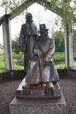 |
The monument is next to the Vecpiebalga Cultural Centre. Its architect was Ausma Skujiņa, and the sculptress was Maija Eņģele. |
|
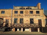 |
18. gadsimta beigās celtās Rundāles muižas ūdensdzirnavas atrodas Pilsrundāles centrā. Ūdensdzirnavas savas pastāvēšanas laikā piedzīvojušas divus postošus ugunsgrēkus, taču laika gaitā to darbība tika atjaunota. Tolaik dzirnavas darbojušās ar ūdens spēku un papildus tam bijusi uzstādīta arī tvaika mašīna. 20. gadsimta trīsdesmitajos gados, kad par īpašnieku kļuva Voldemārs Bergmanis, ūdensdzirnavu ēku atjaunoja un pilnībā nokomplektēja ar tolaik vismodernākajām firmas “O. J. Keller” dzirnavu graudu pārstrādes mašīnām, kā arī tika izvērsta plaša saimnieciskā darbība: labības pārstrāde, galdniecība, vilnas apstrāde un augļu pārstrādāšana. Mūsdienās ūdensdzirnavu ēkā ir izveidots muzejs piecos stāvos, kurā var iepazīties ar dzirnavu darbību. Iespējams sekot līdzi grauda ceļam pa koka šahtām līdz samaltam miltu maisam. Piedāvājumā arī inventāra noma Rundāles ūdensdzirnavu tilpnē. Pieejami SUP dēļi, airu laiva, ūdens velosipēds un kanoe laiva. 2021. gadā tika izveidota neliela alus darītava un uzsākta alus ražošana. Tiek ražots gaišais un tumšais alus, kura visas sastāvdaļas tiek iepirktas Latvijā, bet graudi no vietējiem zemniekiem. Videi draudzīgā iekārta atbilst jaunākajiem ES standartiem un prasībām. Viesiem tiek parādīts alus gatavošanas process, piedāvā degustācijas, kā arī telpas pasākumiem un svinībām. |
|
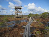 |
Atrodas 3,7 km garās laipu takas vidusdaļā. No torņa paveras viena no Latvijas izcilākajām augstā purva ezeriņu un lāmu kompleksa ainava. Tornis ir populāra saullēktu un ziemeļblāzmas fotografēšanas vieta. |
|
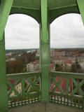 |
From the tower of St Simon’s Lutheran Church, you can see the central part of Valmiera and the banks of the Gauja River. During clear weather, you can see Zilaiskalns Hill. The church contains some cultural and historical treasures, as well as one of Latvia’s most resonant pipe organs.
|
|
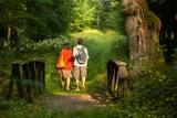 |
The Ungurmuiža park is well known for its outstanding and huge oak trees. Some of them are rotting or dead, and they are home to a great many species, including many that are found nowhere else in Europe. A pathway leads through these noble trees – 1.3km in length, with visitors spending as much as an hour there. The park also contains the only wooden castle from the early 18th century that has been preserved to the present day. There are other cultural and historical treasures, as well.
|
|
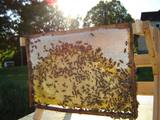 |
This family company offers high-quality and traditional beekeeping products in the Gauja National Park. There are some 110 hives of bees, and the products include honey, pollen, bee bread, wax and propolis. The owners also produce new and unprecedented products which satisfy the demand of clients for something that is unusual, but healthy. You can take a tour and purchase honey. |
|
 |
From the Asote castle hill, which is on the right bank of the Daugava River near Jēkabpils, there is a fine view of the Daugava River valley, the Ābeles Island, and the Kaupre castle hill that is at the northern end of the island.
|
|
 |
The Cemetery of the Brethren of
Lāčukrogs offers a final resting place to
men who fell during World War I.
|
|
 |
The farm is open to visitors all year round, but the best time to visit is during the spring and summer. The farm offers 45-minute lectures about plants, after which there is a 30-minute tour of local plants outdoors. |
|
 3 days
|
The route leads from Riga, the capital of Latvia through beautiful countryside areas to Kaunas, the second largest city of Lithuania. Klūgu landscape garden and park is famous for begonias. Institute of horticulture in Dobele owns a collection of over 200 types and forms of lilac plants. The “Beautiful&Practical” garden is proud of its collection of conifers, and the hosts offer tastings of herbal spice powders, dried berries and fruit. “Rūķīšu tea” is one of the largest farms for medicinal plants in Latvia (purple coneflowers, marigolds, chamomile, etc). Enjoy the beauty of peonia in the collection garden by Andris Berkins. Viestardi tulip garden also grows and processes buckthorn. Next stop is at the vegetable and herb farm “Healthy” producing herbal ointments. Visiting Mint House you will taste mint tea, biscuits, honey with peppermint and peppermint syrups. At Blankenfelde manor you will see a collection of bells and will enjoy natural juices, syrups and pickles produced in-house. In Joniškis, you can visit the White and Red Joniškis Synagogues, the Joniškis Church of the Assumption of the Virgin Mary, and the Joniškis Museum of History and Culture. Jakiškiai Manor has not been renovated and shows authentic elements like ovens, shutters, stairs, doors. There are about 30 different species and varieties of plants growing on the grounds of the Baltic Plant Museum. Šiauliai University Botanical Garden demonstrates heritage rural plant gardens arranged according to the traditions of pre-war, inter-war and post-war periods. Burbiškis Manor and its beautiful landscape and sculpture park is a home to the annual tulip festival. Authentic homesteads representing Aukštaitija region can be seen at Kleboniškiai Rural Household Museum. Baisogala Manor is called royal, since it once belonged to a Lithuanian Grand Duke, its 12-hectare park is one of the most beautiful in Lithuania. There are two beautiful heritage gardens surrounding the museum of Mačiulis-Maironis, a famous Lithuanian poet. Home produced “Happy Foods” can be bought from Garsi Tyla homestead, and you can have a walk in their 100-year-old orchard and see the culinary herb garden. The Lithuanian Institute of Horticulture carries out both scientific and experimental/production activities. You can also buy seedlings, and seasonal fruit and vegetables. At Tadas Ivanauskas Homestead at Obelynė Park you will see a collection of 300 species and forms of plants, including some of the oldest trees on the planet – the ginkgo biloba and the dawn redwood. In Kaunas you will see the Oldest Apple Tree in Lithuania – almost 360years old, 8 metres tall, with a girth of 285 centimetres at a height of 1.3 metres. The Vytautas Magnus University Kaunas Botanical Garden exposes the Lithuanian Heritage flower garden plants according to their botanical classification. The tour ends in Kaunas that was the capital of the country from 1920 until 1939. |
|
 |
The rock is along the main street of Krāslava and is found at Augusta Street 12. After major reconstruction of the city’s infrastructure, the rock was successfully integrated into the surrounding landscape. The rock is 2.8 m long, 2.2 m wide and 700 cm high. It once served as a border stone for the village of Krāslava. It was placed there in 1729 to commemorate the day when the noble Plater dynasty bought Krāslava. The dynasty’s seal is engraved in the side of the rock along with the date when it was installed. Legend has it that Polish King Augustus II dined at the rock after a hunt, and that is why it is known as Augustus’ Rock. |
|
 6 days
|
This tour combines local wine making traditions with an ancient charm of countryside with several medieval castles and baronial estates. The tour goes to Sigulda where on the steep banks of Gauja valley sits three castles. Visit Turaida and Sigulda medieval castles and then go to Krimulda Manor to try their wines. There is also a visit to a family wine maker in Sigulda. Next day there is an excursion of historic village of Ligatne and tasting of local wines located at the sand cave typical for the area. Further on the route there is an impressive Cesis medieval castle ruins and Ungurmuiza Manor which is an only preserved sample of wooden baroque manor architecture in the Baltics. Overnight is at former Dikli Manor which is now an upmarket hotel. Next day the route goes along the coast where is museum of the biggest liar in the world - Munchausen. You can also stroll along sandy beach there. Then visit farm of local winemaker and taste his various wines and then visit Birini Manor for a dinner and have relaxing stroll into their huge park before returning to Riga. |
|
 |
Atrodas Skolas ielā 12, Priekules pamatskolā. Tās krājumā ir plašs Priekules novadā iegūto vēsturisko liecību klāsts – sadzīves priekšmeti, darbarīki, dokumenti, padomju gados izsūtīto un represēto cilvēku atmiņu stāsti u.c. liecības, kā arī Priekules skolu attīstības vēsture. |
|
 |
The café is in the centre of Lizums and offers local foods. The interior design is based on Latvian ornaments. Latvian cuisine: Cold soup, dumpling soup, hunter’s sausages. |
|
 2 days
|
The Ķemeri National Park (est. 1997) covers wetlands, the shallow waters of the Bay of Rīga, overgrown seaside lakes, swamps, damp forests and wetland meadows. There are many important plants (including some 25% of those that are declared to be rare) and animals, including an area where the locations of nesting and migrating birds are protected. The park includes one of the largest swamps in Latvia – the Great Ķemeri Swamp. This is an important location for sulphurous waters and medicinal dunes, and back in history, that was the reason for the establishment of popular spas in Ķemeri. Visitors to the park are interested by educational nature trails, bike and hiking routes and bird watching towers. Route information from Latvijas Lauku forums |
|
|
|
Ap 9 km garā taka (vienā virzienā) sākas Skaņākalna dabas parkā (Mazsalacā) un beidzas pie Ramatas. Tā iepazīstina ar Salacas ielejas dabas parka nozīmīgākajām vērtībām – smilšakmens atsegumiem (Skaņaiskalns, Dauģēnu klintis u.c.), alām, nozīmīgu izmēru laukakmeņiem u.c. Taka marķēta. Tajā izvietoti informācijas stendi, norādes. Jāpadomā par loģistiku – kā nokļūt sākuma punktā. |
|
 |
When you travel along the northern shore of Lake Sauka where the road to Klauce crosses your road, you will see the Sauka Lutheran Church among the trees. This is the third church at this location. It was opened in 1827 and can mostly be viewed from the outside. The altar is decorated with sculptures of St Peter and St Paul, as well as the altar painting “Jesus on the Cross with Mary and John,” which is by J. Doering. The organ was built by craftsmen in Jelgava, and the pipes were manufactured in Sauka. |
|
|
|
Latvijas Valsts mežu laivu bāzē, kas atrodas Kaņiera ezera dienviddaļā (redzama no Lapmežciema – Antiņciema ceļa) kopā ar laivu bāzes ēku apvienots skatu tornis, no kura lieliski pārredzama ezera austrumdaļa. |
|
|
|
Tavern Vedu is located 10 minutes’ drive from Tartu, going in the direction of Narva. In the historic tavern you can taste delicious dishes from local ingredients. |
|


