
| No | Name | Description |
|---|---|---|
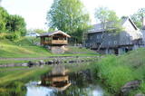 |
An old farm near the river, where water mills have been operating since 1851. |
|
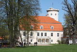 |
The history of Cēsis begins at the Riekstu hill, which is 18 m high and the surrounding area. There was a wooden castle built by the Vendian tribe that stood there from the 11th to the 13th century. The hill is in the central part of the castle’s park, and it offers a fine view of the park, a pond and the ruins of the Cēsis Castle. A long staircase leads to the hill. The Cēsis Castle was built in the early 13th century as the residence of masters of the Livonian Order, and it was one of the most fortified forts in the Baltic region. Alongside is the New Cēsis Castle, which was built in 1777 in a place where gate fortifications had been before. The building houses the Cēsis Museum of History and Art, and an annex contains the Castle Visitor Centre and the Cēsis Tourism Information Centre. From the tower of the castle, we get a good view of the castle ruins, St John’s Lutheran Church and the northern stretches of the city. Opposite the new castle is the stable of the Cēsis Castle Estate and a wheelhouse (both from the first half of the 19th century). Today these house the Cēsis Exhibition Hall. Other buildings include a granary, a hut for coachmen and an old brewery. On the other side of the street is the romantic May park, which was installed during the 1830s. Streets in Cēsis include Lielā Katrīna, Mazā Katrīna, Mazā Kalēju, Kalēju and Lielā Līvu streets and Līvu square with wooden buildings from the late 18th and early 19th century. Torņa Street stretches along the walls of the Medieval castle. Outside the church is a sculpture, “As the Centuries Pass By,” and legend has it that anyone who rubs the lantern of the Old Time Man can see the future. One of the most impressive buildings in Cēsis is St John’s Lutheran Church, which was built in the late 13th century by the Livonian Order. The Roman-style three-segment basilica has elements of Gothic design and a 65 m steeple that was installed in 1853. The building was reconstructed several times during the 20th century and contains grave plaques relates to masters of the Livonian Order and local bishops. The pulpit dates back to 1748, the oak altar was manufactured in 1858, and the altar painting “Crucified One” was painted in 1862. The windows of the altar part of the church contain artistically valuable stained glass. The organ was manufactured in 1907 by the E.F. Walker firm, and it is one of the best concert organs in Latvia. The solar clock with the number 1744 is in the south-wester corner of the church. It is worth scaling the viewing tower of the church. At its foot is Rose Square, which was a market square from the mid-13th century until 1927 and was restored in 2008. This is the central square in the city. During the Middle Ages, a punishment pole and the city well were here. Rīgas Street has been the main street in the old part of the city from the very start, and here we find most of the architecturally distinguished buildings from the 18th and 19th century – the former city hall, the Fābers house and the Princess house. At one end of the street is Liv Square, where there a church, cemetery and the Rīga gate in the city’s walls existed in the 13th century. Today the square is decorated by a lighted fountain at a place where a well was found in the 13th century. On the other end of the street we find a reconstruction of the foundations of the Rauna gate from the 14th and 15th century, offering a good look at Medieval walls and the size and strength of the gates. It is commonly claimed that the national flag of Latvia was born in Cēsis, but it must be emphasised that the flag that is mentioned in chronicles was designed in Cēsis in 1279 as the ideological prototype of the current Latvian flag, while the story of the first national flag actually comes from Valmiera, where it was sewn in 1916. |
|
 1 day
|
Tūrisma gide Ineta Jansone piedāvā ekskursijas grupām uz Ķemeriem un iepazīstina ar Ķemeru kūrorta vēsturi. Kopš seniem laikiem Ķemeri slaveni ar to, ka šeit ir daudz sērūdeņu avotu un ārstnieciskās dūņas. Šurp brauca ārstēties kopš 19. gs. sākuma. 1838. gadā Ķemeros nodibināja kūrortu. Ķemeru kūrortā ārstēja ādas un kaulu slimības, kā arī gremošanas un nervu sistēmas slimības. 1877.g. izbūvēja dzelzceļa līniju Rīga - Tukums, bet 20.gs. sākumā tika ieviesta tiešā dzelzceļa satiksme ar Maskavu. Kūrorts bija ļoti populārs un katru gadu arvien vairāk viesu brauca šurp ārstēties. Īsi pirms I Pasaules kara atklāja elektriskā tramvaja satiksmi starp Ķemeriem un jūru - Jaunķemeriem. Ķemeri atrodas starp purviem un ezeriem, 6 km attālumā no Rīgas jūras līča. |
|
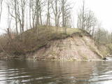 |
Where the little Rumbiņa river flows into the Daugava (on the left bank of the little river opposite the Lielvārde park), there is the Dievkalns castle hill that has been reduced by the waters of the Daugava. It is also known as the Cepure hill. According to antiquities that have been found here, representatives of Baltic tribes lived here from the first millennium BC to the 6th or 7th century AD. The level of the Ķegums hydroelectric power plant can be reached by a staircase from which the best view of this object can be found.
|
|
 |
This reserve dates back to Lake Ancilus, which was one of the original elements of what is now the Baltic Sea. The lake’s ancient shores feature wetlands, forests and flora which are all protected by the reserve.
|
|
 |
The tower on the eastern shore of Lake Engure (next to the meadow for wild cattle, accessible from the side of Bērzciems) offers a view of the reeds, small islands, Great Island, cows and horses of the north-eastern part of the lake. The tower on the northern shore of the lake (accessible from the side of Mērsrags) offers a look at the boating facility and the very overgrown northern part of the lake. The tower at the north-western shore of the lake (accessible from the side of Ķūļciems) shows the Apaļrova island (a footpath), stands of juniper, the boating facility, and the mosaic-like landscape of the lake itself.
|
|
 |
Here you can tour a farm which features goats, horses, rabbits, fowl and livestock. Equine therapy is available, as are horseback, pony and carriage rides. You can purchase goat milk, cheese, cottage cheese, kefir and yogurt. |
|
 1 day
|
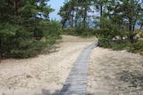
This section of the Baltic Coastal Hiking Route is a comparatively short hike across a beautiful sandy beach, the coastal side of which is bounded by brightly colored pine forests with spectacular dunes and dams of dunes. To get from the beach to Carnikava, the Baltic Coastal Hiking Route will take you through a forest via a promenade. Then it takes a stroll around the Old Gauja River via a levee and reaches the pedestrian bridge over the Gauja River. Both as you start and end the hike, it is nice to sit in one of the pubs and summer cafés located on Vecāķi beach and in Carnikava. |
|
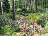 |
This arboretum was established in 1996, when dendrologists Raimonds Cinovskis and Ināra Bondare joined with the local government in Rucava in experimenting with plants on the Rucava castle hill. The first plants were planted in 1998, and ever since then the collection has been expanded in the town centre and outside the Rucava Elementary School. Each year new and exotic plants are brought in from all around the world. A traditional garden festival is held each year in May, when rhododendrons and magnolias are in full bloom. |
|
 |
The historic stone, on which there is carved over 200 years old boundary-mark, sets the border between the Duchy of Courland and the Russian province. Nowadays, it sets the Babīte and Jelgava district boundary. The stone lies to the East of Kalnciems–Peat road (the south of the swamp Labais purvs) at the edge of a forest firebreak and it can be hard to find. To this end, the description of the road map may help: around 400 m south of the car parking lot at Lily Lake from Kalnciems-Peat road to the right (in the east) turns a forest road which leads down from hills Krāču kalni. It should be around 170 m to go until it abruptly turns to the right (to the southeast). Then you must go in this direction until after ~ 0.5 km to turn to the northeast where after further ~ 0.4 km of the current forest road intersection turn to the north. After ~ 0.4 km turn right (to the east) on a big firebreak, on the left (the north) side of which behind the drainage ditch during the non-leaf period there can be seen a rounded stone. Due to the poor condition of roads, the stone can be reached only on foot. |
|
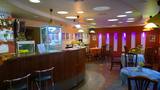 |
The café serves freshly prepared home-cooked food. "Cafe 21 & Putnu Dārzs" rents out rooms for banquets, celebrations, meals, buffets and seminars. Provides food delivery and off-site service. |
|
 |
Until 13th century, Smiltene region was a part of Talava country, inhabited by Latgalians. After Crusaders invasion it was won by the Archbishop of Riga, and he built a stone castle on the steep river bank of Abuls in 1370. The following wars and epidemics did not spare the development of settlement, nor the people. Present shape of the town began to emerge in 19th century along with the vigorous activities of owner of Smiltene manor first Lieven. Until the World War I, wood working factory, hydroelectric power plant (established in 1901, first in the Baltics), and other companies were operating in Smiltene. In 1944 when the German forces retreated, much of the Smiltene historical buildings were destroyed in the fire. |
|
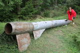 |
Der weiteste Nordpunkt der Juminda Halbinsel mit einer Raketen-Attrappe der Sowjetarmee, der alten Grabstätten, dem Juminda-Leuchtturm und einem Denkmal für die Opfern des Zweiten Weltkriegs. |
|
 1 day
|
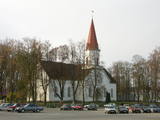
Kihnu Island is the largest island in the Gulf of Rīga and the seventh largest island in Estonia. Its total area is 16.9 km², the island is 7 km long and up to 3.3 km wide. The former seal hunter and fishermen’s island, with around 600 inhabitants, is currently eager to maintain its identity in spite of everything. The unique characteristics of the Kihnu cultural space, like the lifestyle of the community, the diverse cultural traditions, the Kihnu language, music, national costumes and nature, are included in the UNESCO cultural heritage list. A coastal route that goes through four villages – Sääre, Linaküla, Rootsiküla and Lemsi - will help you to discover the cultural and natural values of Kihnu Island. You can visit Kihnu Museum all year round and get insight into the history of the island, including the life of the famous local captain, Kihnu Jõnn. It is also worth seeing Kihnu Church and the cemetery located across from the museum. In the summer, you can enjoy a beautiful view of the island, the surrounding sandbanks and the sea from the lighthouse. The commemorative stone by the former house of Kihnu Jõnn introduces you to the island’s legendary “wild captain”. |
|
 |
Das Museum befindet sich in der Festung von Kopgalis. Im Aquarium des Museums sind Fische und Tiere der Ostsee und anderer Meere und Ozeane zu sehen. Eine Ausstellung. Pinguine und Seehunde. In den Pulverkellern der Festung ist eine Ausstellung der Seefhrt Litauens, aber auf den Bollwerken eine Ausstellung der Gewehr eingerichtet. Das einzige Delfinarium im Baltikum. |
|
 |
This is a comparatively large lake (3 km long and 1.3 km wide). It is shallow (no more than 1.1 m deep) and is classified as a seashore lake. The Vecslocene River flows through it. At the southern end, there is a narrow stream which connects Lake Sloka with Aklo Lake – a shallow and small lake with a dolomite bed at some locations. The best view of Lake Sloka can be seen from the bird watching tower on its north-western shore. This is the only floating bird watching tower in Latvia. Alongside it is the beginning of the 3 km Lake Sloka hiking trail, which passes through the flooded wetlands of the lower reaches of the Vēršupīte. An information stand can be found on the shore of Lake Sloka by the car park. Beyond it is a sulphurous spring. |
|
|
|
Atrodas Sedas purvā (Sedas dabas takas malā) ar plašu skatu uz izstrādātajām kūdras platībām. Sedas taku ieteicams izstaigāt vietējā gida pavadībā T: + 371 2636162. |
|
 |
Pajumäe is a small, nice organic farm located in the green Mulgimaa, and produces various dairy products. You will have the opportunity to look at all stages of milk production - from cows on the pastures to dairy processing. |
|
 |
This is a forested island in the Bay of Finland which is the 6th largest Estonian island and is found 14 km to the N of Tallinn. Two decades ago it was a closed zone, because the Soviet Union had a highly secretive manufacturing plant for maritime mines here.
|
|
 |
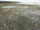
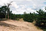
The trail (the length 1.2 km) introduces with the habitats of dunes and century-old pines, partly covered with sand. Biologists estimate that the oldest tree, the “mother of pines”, could be around 200 years old. Coastal pine forests serve as a barrier between the sea and land protecting inland areas from impact of the sea and winds. Felling coastal forests was forbidden by law already back in 1643, during the Duchy of Courland. Still due to economic activities, the seashore forests were often fell and fires occurred there occasionally. As a result, the sand which had for centuries been hold by trees, started drifting at Cape Kolka. In the 1930ies, there were about 142 hectares of sandy areas in the Slītere National Park, and 11.5 hectares of those were drifting sand. To stop drifting, the sand areas were carefully afforested. Afforestation was started before WW I and it was completed in the 1970ies. To plant new trees, first the sand had to be stopped. Just 26km to the south from Kolka there was one of the largest sand dunes in Latvia, 25km in length. Every year it devoured 0.3 hectares of land. The sand was stopped covering it with heather, twigs and branches of pines and junipers. Pine trees were planted between them. Today in Kolka, the old, low pine trees tell about the once drifting sand. After storms, when the water washes the bluff and tree roots are exposed, one can see that the tree trunks once have been covered with sand more than 1 meter high. The trees on the seacoast usually have crooked trunks and flag-shaped crowns formed under influence of persisting sea winds. Now these forests are designated biotope “Wooded dunes of the coast”. Stable white dunes (biotope 2120) do not form in Cape Kolka as they are washed by sea waters during spring and autumn storms. Embryonic dunes develop here (code 2120) with plants that usually grow in dunes. These plants have adapted well to poor soils, heat, drought, and the saline sea water. The Kolkasrags Pine Trail is in Slītere National Park. |
|


