
| No | Name | Description |
|---|---|---|
 |
Tērvetes vīni ir ģimenes vīna darītava Tērvetē. Ražojam vīnu no pašu audzētām ogām un augļiem – avenēm, āboliem, ķiršiem, ērkšķogām, upenēm, cidonijām un no “īpašā dārzeņa” – rabarbera! 2019. gadā esam uzsākuši arī sava vīnogu dārza veidošanu un plānojam piedāvāt saviem viesiem vīnogu vīnu. Mēs - Dace un Sandris Laizāni, Tērvetes vīnu saimnieki esam kaislīgi “vīna mīļi” un šo mīlestību pret vīnu vēlamies nodot arī mūsu viesiem! Jums piedāvājam vīna darītavas apskati un vīnu degustāciju ar omulīgām sarunām par vīna tapšanu jaukā lauku ainavā Tērvetes upes krastā. Atkarībā no sezonas piedāvājam dažādu augļu un ogu vīnu, dzirkstošo vīnu un brendiju degustāciju. Saimniece Dace arī palutinās Jūs ar nelielām uzkodām - mājās ceptu maizi un pašas sietu sieru. |
|
 |
This is an uncommon landscape for the Kurzeme region with a protected biotope – open inland dunes with meadows of silver grass and forests of deciduous trees, including the common hornbeam. Tourists can visit the Muiža (Lejas) sacred stream on the right bank of the Sventāja valley, above which they will find Latvia’s most noble bird-cherry trees. A nice reed pergola has been installed above the stream. Wide are of Sventāja River valley can be overseen from the road before the stream. |
|
 |
The café, located between Talsi and Laidze, on the side of the Talsi-Upesgrīva highway (P127), offers traditional Eastern European lunch and dinner dishes. |
|
 |
Tillu is a home café located in Põlva farm store. The place has a slightly eclectic, bohemian vibe, but is warm and cosy at the same time. Pastries and pies are made here every day, therefore the place is filled with pleasant aromas. |
|
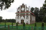 |
Meklējama Gosporos, starp Rīgas – Daugavpils šoseju (A 6) un Daugavu. Apjomā nelielais dievnams būvēts 1820. gadā romāņu stilā no laukakmeņiem senas kapsētas vietā. Tuvāk Daugavai ir izveidota aka, no kuras iztek Svētavots, kam piedēvē dziednieciskas īpašības. Pie baznīcas novietots dobumakmens. |
|
 |
Divas mazas apdzīvotas vietas nacionālā parka dienvidrietumu daļā. No kādreiz piecām Kolski ciema saimniecībām līdz mūsdienām ir saglabājusies tikai viena. Kolski iedzīvotājus līdzīgi kā citviet Baltijas valstīs pēc 2. pasaules kara deportēja uz Sibīriju. Kolski apkārtnē redzamie mājdzīvnieki „apsaimnieko” šejienes pļavas, neļaujot tām aizaugt ar mežu. Tādējādi tiek uzturēta apkaimes vēsturiskā ainava. 3 km dienvidrietumos meklējams Kobasāres ciems. Tā nosaukums (koopa no igauņu valodas nozīmē ala, saar – sala) atgādina par Ziemeļu kara notikumiem, kura laikā cilvēki slēpušies pašu raktās alās. Kobasārē un tam blakus esošajā Apjas (Apja) ciemā var izbaudīt patiesi 21. gadsimtam nepierastas lauku ainavas. |
|
 10 days
|
The tour takes through all three Baltic States – Lithuania, Latvia and Estonia. The route visits the capital cities and some of the most attractive cities and towns in Mid - Baltics. The tour starts in Vilnius, the capital city of Lithuania. Kaunas is the second largest Lithuanian city, standing at the confluence of the Nemunas and Neris Rivers. Riga, the capital city of Latvia, offers a variety of cultural experiences and entertainment. Sigulda is famous for its landscapes and medieval castles. Cēsis is one of the most charming towns in Latvia with many attractions ranging from medieval heritage to nice restaurants, exhibitions and festivals. Valmiera offers art galleries, museums, nature trails and Valmiermuža beer from the famous local brewery. Tartu in Estonia is a university town, with some very popular tourist attractions such as the interactive AHHAA science centre, the largest in Baltic countries. Finish the tour in Tallinn – the capital city of Estonia. Tourist information centres in cities and towns will help you with maps, information on sights, attractions and guided tours, food, shopping and public transport. |
|
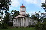 |
Mūsdienās redzamo (pēc skaita – trešo) baznīcu cēla laikā no 1835. - 1837. g. (ampīra stilā) Mārča Sāruma vadībā. Arī šīs ēkas projektēšanā par paraugu bija ņemts Pievolgas vācu baznīcu veidols, tādēļ tā līdzīga Dzērbenes luterāņu baznīcai. Dievnama altāri rotā Otto Donnera fon Rihtera glezna “Kristus debesbraukšana” (1898. g.). E. Martina firmā būvētās 10 reģistru ērģeles (1901. g.) darbojās arī šodien. Pie Drustu baznīcas atrodas 1932. g. atklātais un formās iespaidīgais (E. Kuraua firmas veidots) granīta piemineklis 1. pasaules karā un Latvijas Brīvības cīņās kritušo piemiņai. Nelielā baznīcas sienas nišā novietota piemiņas plāksne komunisma terora upuriem. |
|
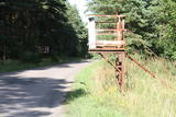 |
This facility was used in the past by communications officers, and it was also a training centre. The Ventspils Home Guard Battalion is housed here at this time. The facility is not open to civilians. Along the road there are metal structures which show where the entrance to the facility was once located.
|
|
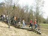 |
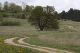
This path is found on the right bank of the ancient Abava river valley. The visitor will be able to view places where underground streams create wetlands, various kinds of meadows, a stand of juniper bushes, etc. The area is “managed” all year long by “wild” cows. The shore of the ancient valley can be climbed (some 200 steps), and the view is magnificent. It is recommended that the trail be visited in the company of a knowledgeable guide. There is a shorter path that is 600m long, along with a longer one that is more than a kilometre in length. It will take an hour or so to traverse it. Objects are found in the ancient Abava valley nature park.
|
|
 |
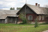
An ancient Latgalian settlement. During the 10th century Kraslava district was under authority of the Prince of Polotsk, but the 13th century - under the authority of the Livonian Order. Until the beginning of 18th century it existed as a manor centre. In 1729 Kraslava was bought for 1400 thalers by Johan Ludvig Plater. Plater family ruled Kraslava for two centuries. In the of the18th century Platers began construction of Krāslava palace. After first division of Poland in 1772 Latgale was annexed to Russia. Kraslava began to perish. After construction of Riga - Daugavpils - Vitebsk railway (1865) economic life flourished again. Kraslava was little affected by the World War II, therefore, early wooden buildings of 20th century remained almost untouched. |
|
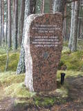 |
Around 6 km in length and an isolated route stretching between Ragaciems and Klapkalnciems where, as stories about olden days tell, robbers used to attack travelers. Around 1.5 km before Klapkalnciems (going from the side of Ragaciems), in the dune by the sea there is installed a commemorational stone dedicated to the Finnish jaeger battles. It was installed on December 09, 1997. The stone has "travelled" from the south-eastern part of Finland where in 1940 it served as an anti-tank defense. In the monument, there are engraved the words, "Here during World War I, from August 1916 to December fought the Finnish yeagers". In turn, in Klapkalnciems there is installed a commemorational stone in the place where there are buried five Finnish soldiers. |
|
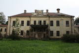 |
Šī vairāk ir uzskatāma par vēsturisku vietu, nekā tūrisma objektu, jo muižas pils atrodas avārijas stāvoklī un apskatāma no ārpuses! Mūsdienās redzamais muižas komplekss ir veidojies 19. - 20. gs. mijā, bet muižas pils (vēlīnais klasicisms) - 19. gs. pirmajā pusē. Vēlāk tai piebūvēja neobarokālus torņus abos ēkas galos. Vienā no tiem atradās kapela, otrā – bibliotēka. 19. gs. tika uzsākta ainavu parka un dendrārija izveide. 19. gs. beigās pilī norisinājās plaši remontdarbi, un tās īpašnieki – Kerbedzu dzimta ēku līdz pat 1. pasaules karam atvēlēja māksliniekiem. No 1920. - 1975. g. muižā darbojās pamatskola, tad ēkas kā noliktavu izmantoja kolhozs. |
|
 |
The Karosta prison cannot be described, it must be experienced and survived. That’s an opportunity for everyone. This is the best example in Latvia as to how the military heritage can be used for tourism purposes. Others can learn from this site. |
|
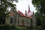 |
A bit less than one kilometre from the Aizkraukle castle hill, the church can be seen from the Rīga-Daugavpils highway (A6). The church was built in 1688 on the steep banks of the
|
|
 |
Apdzīvota vieta ~ 1 km dienvidos no Daugavpils – Krāslavas (A 6) ceļa, kas pazīstama ar savu neparasto nosaukumu. Interesanti, ka vietvārds saistīts arī ar iedzīvotāju uzvārdiem, ko var redzēt tāda paša nosaukuma kapos. Ciema apkaimē pazīstams ir Lielo Muļķu svētavots, kuru gan nezinātājam ir grūti atrast, tādēļ ieteicams izmantot vietējā gida pakalpojumus, apvienojot šīs vietas izziņu ar biškopības saimniecības „Cīruļi” apskati. |
|
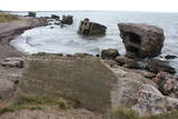 |
This is one of the most visually expressive coastal defence batteries in Latvia. Why? Because most it has been fully or at least partly washed into the sea, creating a truly unusual landscape, particularly during stormy weather. This is an historical monument which is subject to the mighty power of Mother Nature. The battery can also be seen from the Northern breakwater of Liepāja. It’s worth hiking the four kilometres along the beach to the Northern Forts. Along the way, you can take a look at the No. 23 Coastal Defence Battery.
|
|
 |
"Barono Vila" is a corner of paradise with a large and deep fishing pond, deer in enclosed meadows, sheep, forests rich with mushrooms and berries, clear lakes and the curves of the Sventāja River, which are popular among tourists. The restaurant offers fresh, tasty and high-qualified food made of venison and mutton, as well as oven-baked Lithuanian rye bread and the house speciality -- "Barona plov" cooked on a campfire. |
|
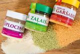 |
The Rauna cheese factory is owned by Ceriņš family, and for the past 10 years it has offered high-quality and nutritious products to its consumers – cheese, butter and macaroni. The most popular product is “Green cheese,” in which one of the main ingredients, fenugreek, grows in the factory’s garden. Fenugreek is a perennial with five leaves and blue flowers. While the new shoots are soft, they are dried in a wood-fired drying house. Then the fenugreek is ground up, sieved and added to a mass of protein that is put in thin layers in special wooden boxes and allowed to dry. After the fenugreek is added, the cheese gets its typical taste, colour and smell. Groups of 10 or more can apply in advance for tours of the factory and learn about how the cheese is made. |
|
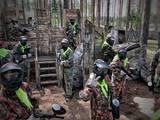 |
Aktīvās atpūtas peintbola parks un kempings ir atvērts apmeklētājiem no 2008. gada un šobrīd ir viens no lielākajiem peintbola parkiem Latvijā. Spriedzes un adrenalīna pilni piedzīvojumi nodrošināti kā skolēnu grupām, tā arī kolektīviem un draugu pulkam. Peintbola parks „Bušas” piedāvā lielus peintbola laukumus, ar šķēršļiem, mājiņām, ejām, torņiem, automašīnām – pilnvērtīgai un aktīvai peintbola spēlei. Peintbola parks „Bušas” ir sertificēts un drošs peintbola parks ar pieredzējušiem instruktoriem, kas seko peintbola spēlei visu tā laiku, lai mazinātu negadījuma iespējas, iepazīstina ar drošības noteikumiem un iepazīstina ar ekipējuma lietošanu. Peintbola parkam ir arī otra lokācijas vieta Rīgā, Matīsa ielā 8 Parkā ir iespējams arī pārnakšņot dažāda tipa naktsmītnēs - lielākā un mazākā kotedžā, pirts mājā, kā arī izmantot kempinga teritoriju telts būvēšanai. |
|


