
| No | Name | Description |
|---|---|---|
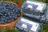 |
This beautiful farm near the hillocks of Lake Kālis grows raspberries, strawberries, cranberries and blackberries. During the season, you can pick, taste and buy the berries. Informational tours are also available. |
|
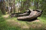 |
In the 1960s, the Soviet Union banned individual fishing in the sea, and the motor boats which had no other purpose were simply beached in the dunes. It is said that members of the Border Guard often set the boats on fire. Another story is that the Border Guard banned an ancient tradition of burning old boats on Summer solstice Eve. Along the road to the cemetery is the old net barn, which is a residential building today. |
|
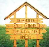 |
„Upmaļi” is the family house of writer Janis Klīdzējs who has written 8 novels, 11 storybooks, 2 essay books
and reflections about Latgalian catholic-Latvian mentality. Janis Streičs (famous Latvian film director) shot a film
based on the novel of Janis Klīdzējs called „The Child of a Man”.
|
|
 |
This lovely farm features lilies, peonies and other flowers, as well as a beautiful rock garden and a dendrological park that is under development. Bees from more than 100 hives produce honey. The lady of the house will take you on a tour and offer plants and honey products for sale. |
|
 |
A very beautiful and expressive tree, it is found on the land of what was once the Vīceži Semi-estate.
|
|
 |
Pitas ir pēc inovatīvas žāvēšanas tehnoloģijas radītas augļu, ogu un garšaugu garšvielas, kuras ražo mājražotāja Lorita Miķelsone. Mājražotāja labprāt ļaus nodegustēt un iepazīstinās ar Pitām jebkuru interesentu, uzņemot apmeklētājus Skaisto un praktisko ideju dārzā Dobelē. |
|
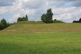 |
This is one of comparatively few castle hills along the banks of the Daugava River that is not overgrown with trees and bushes, which means that it has a classical castle hill form that is part of the local landscape. The Dignāja castle hill was settled during several periods, particularly between the 5th and the 9th century AD, when it was an important centre. Archaeologists have found that Lettigalian tribes lived here. After the Holy Crusade invasion, the Livonian Order built a castle on the hill that has not survived. It is said that there was once an underground passageway under the hill. The hill itself offers a lovely view of the Daugava River valley. World War I trenches have been preserved the area. There was once a settlement at the foot of the hill. |
|
 |
The café is in the historical centre of Tukums and offers various Latvian baked goods and pastries. |
|
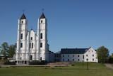 |
This is the centre for Catholicism in Latvia and a destination for pilgrims from all around the world. Its origins date back to 1699, when the Dominican Order established a cloister. One year later, it built the first wooden church. The brick Church of St Dominic and the buildings of the cloister were erected between 1768 and 1800. The Baroque church is distinguished by two towers that are 60 metres high. The pulpit, organ prospectus, organ, prayer bench and pews come from the 18th century, while the side altars date back to the early 19th century. The central altar includes the painting “The Miraculous Mother of God of Aglona,” which is thought to have healing properties. For that reason, it is unveiled only during important events. In advance of a visit to Latvia by Pope John Paul II in 1993, the complex underwent major rebuilding and restoration. On August 15 each year, hundreds and thousands of pilgrims arrive in Aglona to celebrate the assumption of the Virgin Mary. The holy stream of Aglona is 100 metres to the East of the basilica. |
|
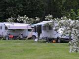 |
The "Jurmala" campsite is located in the park territory of the "Rīgas Līcis" sanatorium and offers facilitated tent, camper and caravan sites, as well as holiday homes for rent. The campsite is located next to the beach and is suitable for recreation with family and friends, as well as for organizing a variety of thematic and recreational events. The proximity to the "Dubulti" and "Jaundubulti" railway stations makes it easy to move around Jurmala or get to Riga. The campsite is also suitable for families with pets. |
|
 |
This museum is at the Griežioneliu farm in the Anīkšču region. It was opened in 1968 as an authentic farm with plants that come from that time. The history of the farm is related to biological heritage. |
|
 |
Dagda is mentioned in the historical sources of 17th century as a trader village. In 1772, Dagda district was included the Pskov province, but in 1802 - Vitebsk province. In 1905 widespread peasant unrest took place here, during which many important architectural monuments were destroyed. Town was not spared also by the two world wars. What's to see for the tourist here? In the centre of Dagda historical buildings - houses, built of red brick - the so-called "Jewish tradesmen houses" are preserved. Dagda is the only place in the Latvia, where every year is celebrated Anne's Day in the town's park! |
|
 |
Laidze Parish Farm "Cukuriņi" is engaged in sea buckthorn cultivation. The farm covers about 10,000 sea buckthorns on an area of 6 hectares. The fields are treated with a computerized irrigation system. The owners of the grown berries both sell and process it themselves, obtaining sea buckthorn juice, oil and frozen berries. |
|
 |
Auf dem Urbo-Hügel befindet sich der 1953 ronovierte schönste Leuchtturm an der Küste Litauens. Das Licht von diesem Leuchtturm kann man in einer Entfernung von 22 Seemeilen sehen. |
|
 |
The restaurant "Barons Bumbier’s" is situated in the shopping centre "Kurzeme", at the very heart of the city next to the place which is knows as the heart of Liepaja – the Rose Square. The restaurant offers substantial traditional Latvian cuisine. The menu is designed in a way for every gourmande to get to know and evaluate traditional dishes of Latvian cuisine, which, cooked by experienced chefs, will surprise anyone with its variety. Latvian cuisine: Vegetable soup, cold beet soup, sliced pork, strawberry soup. |
|
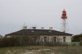 |
In Soviet times, all lighthouses were military objects. Today the lighthouse at Pape is managed by the Latvian Maritime Administration, and it can only be viewed from the outside.
|
|
 |
“Pagrabiņš” is located in the Old Town of the city, in the historic town hall building. Its interior preserves historic vaults and stone walls that have been decorated with photo exhibitions. In summer, the guests can enjoy their meal on a terrace over the small River Alekšupīte. |
|
 |
Located in Obinitsa Village, open daily in the summer, please book in advance in winter. White bread and rye bread baking masterclass with natural yeast preparation. The café bakes brown country bread, bread with seeds, various white breads. |
|
 |
Mailīšu fabrika atrodas Ērgļos, un tā ir radīta ar mērķi saglabāt rokdarbu tradīcijas un prasmes. Te auž vilnas, lina un zīda darbus - segas, plecu lakatus, linu dvieļus. Viesiem ir iespēja apskatīt dažādu veidu stelles, kuras izmantotas Latvijas teritorijā jau sākot no 9.gs. |
|
 |
The Strūves Park is toward the northwest of Jēkabpils, on the left bank of the Daugava, and opposite the Ādamsona (Krustpils) island. The park was established in the 19th century as a place where the city’s residents could relax and hold celebrations. It can be said with absolute certainty that this is a place of global importance, because the park contains a memorial stone to Professor Friedrich Georg Wilhelm Struwe (1793-1864) from the University of Tartu. He was an astronomer and geodesist. The stone is at a place where Struwe completed his land survey of the Vidzeme Province of the Russian Empire. The meridian location which Struwe identified (and other points related to those locations are found in many other European countries) is on the UNESCO list of world heritage. |
|


