
| No | Name | Description |
|---|---|---|
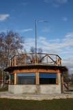 |
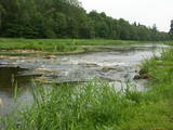
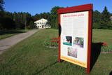
Pirmā ir uzcelta uz vienstāvīgā apmeklētāju centra jumta. No tās paveras plašs skats uz Kīdevas ciemu, ostu un niedrēm apaugušo Matsalu līča ziemeļdaļu. Austrumos no šīs atrodas vēl viena - divstāvīga putnu vērošanas platforma. No Kīdevas līdz Puisei gar Matsalu līča var doties pārgājienā pa 5 km garo dabas taku. To izejot, novēroto putnu sugu klāsts noteikti būs lielāks! |
|
 |
Piedāvā ļoti gardus Lietuviešu tradicionālos ēdienus. Var pieņemt līdz 300 personām. Ir āra terase un dzīvā mūzika. Pieņem bankas kartes, pieejama autostāvvieta. |
|
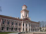 |
The late Baroque and early Classicism building was commissioned by Duke Peter Byron of Courland and Zemgale, and it was built between 1773 and 1776 on the basis of a design by a Danish architect. It was the castle of Duchess Anna. The first university in Latvia, Academia Petrina was established here in 1775 and named after Duke Peter. The first observatory was installed at the academy in 1772, and a high school was in the building during the age of the Russian Empire. Among graduates are distinguished Latvians such as Krišjānis Barons, Jānis Alunāns and Jānis Čakste, as well as the Lithuanian Antanas Smetona. The Jelgava Museum of History and Art took over the building in 1952, and in 1975 it was named after the Old Master Ģederts Eliass (1887-1975). The exhibition speaks to the history of the city and surrounding area during and after the period of the Duchy of Courland and Zemgale. Outside the impressive building are four cannons from the period of the duchy, as well as monument to Eliass that was designed in 1987 by the sculptor Jānis Zariņš. Another monument, “Lāčplēsis and the Black Knight,” was designed by the sculptor Kārlis Jansons and commemorates the liberators of Jelgava. |
|
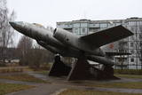 |
A rare monument survives in Skulte – a Soviet-era jet bomber, the IL-28, which supposedly was equipped to carry winged missiles. The airplane is on three cement pedestals.
|
|
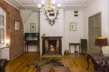 |
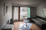
The Vijciems Hunting Castle building houses an elegant design guest house Bergervilla. Each room has an individually designed design, historic furniture and a special atmosphere. There are 4 rooms available - a standard room, a two-room suite and two deluxe rooms with a private balcony and a bathtub. Each room is given the name of a forest beast or bird - Owl, Mednis, Deer and Elk. There is also a living room and library for guests to relax in, as well as a fully equipped kitchen for cooking. Free Wi-Fi and parking are available. |
|
 |
This park was set up to protect the lovely ancient valley of the Dubysa River. This is one of the most popular rivers for water tourism in Lithuania, because it has a significant drop with rapids and beautiful shorelines.
|
|
 |
Vēršupīte is a small river which curves through the
town of Ķemeri and has more than 10 small and
romantic bridges across it – each with its own name.
|
|
 |
This is a route for hikers and bicyclists, starting at the village of Vaidava and then moving along the eastern shore of the narrow Lake Vaidava, which has steep cliffs around it. The trip covers the Veļķi baronial estate, the “Swedish pine”, the famous Vaidava (Metimne) hillfort, a series of streams, the great Rubene rock, the Vaidava baronial estate on the western shore of the lake. After that, the trail leads the visitor back to the starting point.
|
|
 |
The present wooden church on the hill was built in 1947 but today it has been restored. Currently, the deanery of Rezekne is located there. Every day you can see it from the outside. Until 1960, in Dukstigals there were two congregations: White Dukstigals (Šadurska) and Black Dukstigal (Slobodska). In White Dukstigals, the church was built in 1775. In 1960, during the time of the Soviet power, the church was violently demolished, despite the fact that it was an architectural monument and the oldest wooden church in Latgale-367years old! The "excuse" was the explanation that one congregation must not have two churches. |
|
 |
Mācību drava "Kāre" piedāvā iepazīties ar bišu valstības noslēpumiem. Interesanta iepazīšanās ar brīnumiem un noslēpumiem bišu saimes dzīvē. Apmeklētājiem ir iespēja ietērpties speciālos aizsargtērpos un bitenieka vadībā iepazīties ar dzīvas bišu saimes smaržu. Veselībai un dzīvespriekam iespējams iegādāties - medu, bišu maizi, bet romantiskai noskaņai - smaržīgas bišu vaska svecītes. |
|
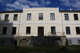 |
Atrodas stāvā Tebras (Dzirnavdīķa) ziemeļu krasta augšdaļā (Skolas ielā 1). Ēka celta 19. – 20. gs. mijā kā Aizputes muižas jaunā kungu māja. Tajā atrodas Aizputes novadpētniecības muzejs (no 1999. g.) un Aizputes TIC. Ekspozīcija par Aizputes pilsētas un apkārtnes vēsturi tiek pasniegts saistošā veidā, ļaujot apmeklētājiem iejusties vairāku gadu desmitu seno notikumu atmosfērā. |
|
 |
The Rubeņu (Rubenes) park dates back to the mid-1950s and is toward the north of Rubeņi, on the banks of the little Dzirnavupīte River. There are beautiful ponds, a stage, a rock garden and a playground for the kids. The cultural centre that is alongside the park features a monument to the poet Rainis which was unveiled during Poetry Days in 1969 and was produced by the sculptor Kārlis Baumanis. |
|
 |
Wine production at Allikukivi takes place in the old servants’ house of the broadcloth factory director. Guests are welcome to taste a wide variety of drinks on the estate's balcony and explore the secrets of wine making, history of the manor and berry plantations. Manufacture of fruit and berry wines using Estonian recipes. |
|
 |
The saloon is on the shore of Lake Alūksne and the Jaunsētas country tourism and leisure centre. The log saloon’s interior is based on the style of the 17th century, when a girl was born in the area who was raised by her foster father Ernst Glick and would later become Empress Catharine the Great, Wife of Peter the Great of Russia. |
|
 7 days
|
During this tour you experience the different ways of using milk either for edible products or body treatments. From Riga, through historic sea and spa resort Jurmala, the route goes to goats farms where you taste cheeses as well as exclusive ice-cream from goats milk. Then visit Dundaga Castle and try local diary products there. At Roja experience local traditions having fishermen meal and attractions Then the route goes along unspoiled seaside beaches of Cape Kolka to well maintained town of Ventspils from where it turns inland to the picturesque Kuldiga with well preserved wooden architecture. Further on enjoy beautiful Milk Manor where you could experience lavish spa treatments based on milk. There is also Milk Museum located where you can follow the milk route from a cow to the tables, also possible to try some old fashioned practical jobs like butter making. Further on the tour turns sweet. Visit candy factory in Saldus where traditional hand-made toffees are made. Then on menu is ice-cream at Druva. Next - sightseeing at Jelgava which used to be the main seat of the Duke of Courland. Visit cheese producer at Eleja and before returning to Riga visit splendid Rundale Palace which is regarded as a beautiful pearl of the Baltics. |
|
 |
Motel Marine is located close to the centre of Ekenäs and is a minute's walk away from the beach. Here reception works 24 h and is always ready to help you. This motel offers different kinds of rooms starting with single rooms to big family rooms with kitchen included. All rooms have their own entrance. There is also a restaurant and sauna in the motel. |
|
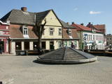 |
Tukums in the historical sources is mentioned in 1253 agreement of the Livonian Order and the Bishop on the division of Kursa. If the town's name is translated from the Liv language, it means "a pile, mountains of sand". at the beginning of 14th century German merchants and craftsmen settlement was formed at the Livonian Order stone castle, whose flowering was facilitated by the proximity of Riga - Prussian road. Later the city was largely influenced by the construction of Riga - Tukums railway in1877. During the Soviet period the on the eastern outskirts of Tukums, the largest Soviet military airfield and military town in the Baltic States was deployed. Today Tukums is a district centre of the same name with a wide range of services offered to tourists. |
|
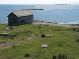 |
No Vilsandi bākas un tai tuvākās apkaimes ir labi saskatāmas leģendārās Vaikas salas. Tām ir piešķirts rezervāta statuss, tādēļ salas var apskatīt tikai no attāluma. Mazākā no saliņām - Kullipank ir tikai pārdesmit metrus diametrā. Tā ir jūras ūdeņu izrobots zemas un asas dolomīta klints fragments, kas klāts ar oļiem, nelieliem laukakmeņiem un kādu atsevišķi stāvošu lakstaugu. Domājams, ka vētru laikā tā pazūd zem jūras ūdens. Savukārt, Alumine Vaigas – Apakšējā Vaikas sala ir lielākā no sešām salām. Šīs salas diametrs ir ~ 150 m un tā paceļas vismaz kādus divus metrus virs jūras līmeņa. Uz salas ir bagātīga veģetācija un pat kāds zems krūms salas centrā. Redzami arī metru augsti atsegumi. Uz salas vēl joprojām atrodas 20. gs. sākumā celto „putnu māju” paliekas, kas bija domātas ligzdojošo putnu piesaistīšanai. |
|
 |
Suhka farm observes old traditions and serves local food. It also offers accommodation in a picturesque location. In addition, here you can learn of hiking routes in places you will not hear about elsewhere. |
|
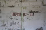 |
The Staldzene Zenith Missile Brigade used a large territory and a number of major buildings. Some of these are now privately owned, and a fish smoking facility has been installed at one of them.
|
|


