
| No | Name | Description |
|---|---|---|
 |
This craftsman uses the black ceramics technique. You can watch him opening the kiln, take part in creative workshops, and commission or purchase ceramics products. |
|
 |
Puderova Old-Believers Prayer House. The architectural monument of local importance was built in
the beginning of the 20th century.
|
|
 |
This is one of the oldest open-air museums in Europe, featuring 118 old buildings from all cultural and historical regions of Latvia. You’ll be able to our farms, craftsmen’s and fishermen’s farms (including Liv ones), and a farm once owned by Russian Old Believers in Latgale. Annual celebrations are held, and educational programmes are available. Craftspeople do their work at the museum, and you can quench your thirst at the Priede saloon. |
|
 |
The Rožlejas farm is in the Džūkste Parish of the Tukums Administrative District, where the Eastern Courlandian highlands interact with the Heath lowlands. The parents of the current owner, Jānis Ukše, began work there in 1989, establishing a natural farm to grow sugar beets and then also wheat. Thanks to thoughtful farming, Rožlejas has, over the past quarter-century, turned into one of the largest grain farms in Western Latvia. The owners have taken active part in EU projects to purchase modern equipment and to build hangars for the storage of grain and equipment. The farm specialises in winter barley and winter wheat, using ~1,200 ha of land for that purpose. |
|
 |
Naukšēni Winery is an organic farm producing cider from Paradise apples. Our Story Apples Ciders For Visitors Where to Buy |
|
 |
Vilsandi bāka sāka darboties 1809. g. Ja uzmanīgi palūkojas uz torņa, labi redzams, ka tas ir vairākas reizes paaugstināts. Tagadējās bākas augstums ir 37 m, bet gaismas elements atrodas 40 metrus virs jūras līmeņa. Bāka ar apkārtējām ēkām ir apskatāma tikai no ārpuses. Ja pa Vilsandi arhipelāgu ceļo ar jūras laivu vai citu peldlīdzekli, tad bāka kalpo kā ļoti labs orientieris daudzo salu, līču un pussalu labirintā. No bākas redzama jūras krastā uzceltā glābšanas stacija. Pateicoties tai, Vilsandi ūdeņos izglābti 29 cilvēki, 2 suņi un 1 kaķis. Tā stāsta vietējie. |
|
 |
The restaurant is on the seashore with two terraces and a lovely view of Jūrmala. Latvian cuisine: Marinated herring with cottage cheese, potato pancakes, fried Baltic plaice, lamb, Latvian cheeses. |
|
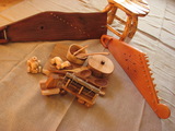 |
Guntis Niedoliņš is a master craftsman, and at this workshop he manufactures wooden jewellery, furniture, interior design objects, spoons, shovels, etc. |
|
 1 day
|
Dodieties ekskursijā, lai gūtu ieskatu lauku profesijā un dzīvesveidā, kā arī iegūtu jaunus iespaidus un labu atpūtu visai klasei. Ekskursijas laikā apskatiet iespaidīgākās un krāšņākās smilšakmens klintis Vidzemes piekrastē, kur viļņi ir izveidojuši līdz 6 m augstu stāvkrastu. Pēc tam apmeklējiet muzeja ekspozīciju, kura iepazīstina ar leģendārā fantasta un melu karaļa piedzīvojumiem un dzīves gaitām. Turpat netālu mežā izveidots vairākus km garš taku tīkls, un taku malās izvietotas dažādas koka skulptūras. Ekskursijas noslēgumā dodieties uz keramikas darbnīcu, lai uzzinātu, kā no māla top dažādi trauki un sadzīves priekšmeti, kā arī paši pamēģinātu roku kāda priekšmeta izvirpošanā. |
|
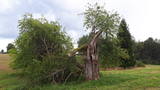 |
This is the thickest European wild apple tree in Latvia. It is just lovely when it is blossoming.
|
|
 |
Izcila lokveida taka (4,5 km), kuras lielākā daļa (koka laipas) ved pa Rīsas purvu (Riisa raba). No takas un divstāvīgā koka skatu torņa ir vērojami purva ezeriņi, lāmas, un purvaini meži. Ja nacionālā parka apskati sāk no ziemeļu puses, tad šī taka ir labs ceļojuma iesākums! |
|
|
|
The town of Subate was first listed in documents in 1570, when Duke Gotthard Kettler of the Duchy of Courland sold the Subāte marketplace to Count G. Plater-Sieberg. When the Plater-Sieberg dynasty converted to Catholicism in the mid-17th century, Lutherans in Subate protested by moving to the eastern bank of Lake Subate. That was the property of the Prode Estate (only ruins remain at this time), which was owned by the Osten-Sacken dynasty. In 1685, the Osten-Sackens built a Lutheran church for the “refugees,” and Jaunsubate was established around it. Both parts of the town were merged again in 1894. During Latvia’s liberation battles in 1919, Subate was liberated by Lithuanians, at which time the town was divided up between Latvia and Lithuania (though the border between the two countries was set at the previous line in 1921). The historical centre of Subate was established between the 16th and the 19th century, and it includes four churches for various congregations and low wooden buildings which stretch along narrow and curvy streets. The town is on the shores of a sub-glacial depression with Great Lake Subate and Lesser Lake Subate therein. This provides the town with unusual landscapes for Latvia. |
|
 16 days
|
This grand hiking tour is provided for experienced hikers wishing to walk along a large part of the coasts of Latvia and Estonia, gain a detailed impression about the diverse coastal landscape, nature, birds and animals of the Baltic Sea. The Baltic Coastal Hiking Route sometimes runs through sandy beaches, sometimes along sections of beach covered in stones and pebbles. Sometimes the trail goes through coastal forests or stops at a fishermen’s village. There are many floodplain meadows, lagoons and shallow bays on the Estonian side, so sometimes the path goes along coastal trails and roads. In the end section of the route you will feel Estonia’s Nordic nature more. Part of the route runs along a sparsely populated seashore where you can be alone with yourself, but you will also be able to visit the most prominent cities. You will visit both capitals: Rīga and Tallinn. Enjoy the hospitality of the resort towns of Jūrmala, Pärnu and Haapsalu. During the hike, you will also get acquainted with the regions of small ethnic cultures: the Livonians in Latvia and the inhabitants of Kihnu in Estonia. |
|
|
|
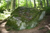
Eine Asstellung der Steine unter freiem Himmel, eingerichtet vom litauischen Ärzt Intas Vaclovas (1925 – 2007). Ein Museum der einzigartigen Steine. |
|
 |
Getliņu ekoloģiskais poligons ir Latvijā unikāls piemērs ekoloģiski saderīgu darbības virzienu ieviešanai. Tā energobloka saražotais siltums tiek izmantots siltumnīcu apsildei, kas nodrošina ideālu vidi lauksaimnieciskai ražošanai (puķes un tomāti - lielaugļu tomāti, tumšsarkanie tomāti, aveņkrāsas ķekartomāti) gada aukstajos mēnešos. Poligona teritoriju (zālāju) nogana ar aitu ganāmpulka palīdzību. |
|
 |
This park surrounds the mansion of the Biržuvenai Estate, and it is based on the terrain of the Virvite River and an old river that provides water for the park. The central part of the park is regularly designed, while the rest has elements of landscape. Opposite the estate is a glass sculpture, and on its western side is a wooden pergola. Local trees dominate in the park, but there are also trees from other countries. Of importance is a group of oak trees on the banks of the river, as is an alley of linden trees that leads to the pond in the direction of the estate. |
|
 |
This farm has some 150 hives of bees which are carefully tended by beekeepers. The farm also produces nectar plats such as buckwheat, clover and phacelia. You will learn all about beekeeping and taste and purchase beekeeping products. |
|
|
|
Līdz 40m augsta ar mežu apaugusi Gaujas labā pamatkrasta nogāze ar vairākiem smilšakmens atsegumiem. Viens no tiem atrodas nogāzes lejasdaļā un veido 7m platu 5m dziļu nišu. Otrā krastā – vairākus metrus augstais Leimaņu iezis. Abi atsegumi atrodas aiz Amatas ietekas.
|
|
 |
Vienu kilometru garā lokveida taka, kas ved pa lielāku nacionālā parka meža masīvu, uzskatāmi attēlo Žemaitijas augstienes un tuvākās apkārtnes reljefa veidošanās vēsturi. No takas augstākā punkta – Mikitai kalna, kas ir sens pagānu upurkalns, paveras (ainaviska stiga) tālākas apkārtnes skats. Kā takas interesantākie apskates objekti ir jāmin teikām apvītais akmens ar Velna pēdu un ar akmeņiem izliktas akas paliekas. |
|
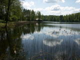 |
Lake Salājs is full of bays and islands. Alongside Lake Little Solojs, which is next to Lake Salājs, is the Milka castle hill and a leisure facility there. This is a beautiful area, and it is protected for environmental purposes. |
|


