
| No | Name | Description |
|---|---|---|
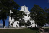 |
The first wooden Catholic church in Dagda was built in 1705, while the church that is seen today was built in the Baroque style during the latter half of the 18th century, the work financed by a local nobleman. Important interior elements include the altar, the pulpit, the organ, a monument to the Hilsen dynasty, etc. To the North of the church is historical Dagda itself, with typical red brick buildings from the early 20th century that are known as the former homes of Jewish merchants.
|
|
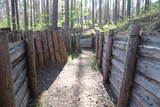 |
Ar Kara muzeja informatīvo atbalstu Garā kāpā pie Antiņiem ir rekonstruēta daļa latviešu strēlnieku nocietinājumu sistēmas. Aspkatāmas ierakumu pozīcijas un vairākas zemnīcas. Netālu atrodas bijusī un no dzelzsbetona veidotā medikamentu glabātuve. |
|
 |
Atrodas Skolas ielā 12, Priekules pamatskolā. Tās krājumā ir plašs Priekules novadā iegūto vēsturisko liecību klāsts – sadzīves priekšmeti, darbarīki, dokumenti, padomju gados izsūtīto un represēto cilvēku atmiņu stāsti u.c. liecības, kā arī Priekules skolu attīstības vēsture. |
|
 |
Elkas kalna saimniecība is located on the top of the scenic Elkas Hill, the place where the Gauja begins. Herbal teas, birch sap, jams and other healthy delicacies from local meadows and home-grown plants. There are also nature workshops, open-air picnic areas. |
|
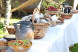 |
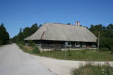
This facility is in the historical village of Pape in Southern Kurzeme. Accommodations are available in an historical granary with a roof made of reeds. It is appropriate for inhabitation during the late spring, the summer and the early fall. There are three bedrooms, a small front room and a kitchen, with two floors in all. The building will fit eight people. This is an ideal location for creative camps, plenary sessions, master workshops and other activities. There are tenting areas for as many as 80 people. The Mikjāņi farm observes local traditions and offers traditional foods such as “herring on coals,” white butter with boiled potatoes, fish soup, etc., for visitors who apply for a meal in advance. This offer is only available to groups which register in advance. |
|
 |
It lies between Pīlādžu street and the left bank of the river Siliņupe. In the 3rd to 2nd millenium B.C., there was a fishermen and hunters' settlement in the place of which there is installed an informational commemorational stone (Sculptor O.Skarainis). The settlement near the river Siliņupe is the oldest known human settlement in the area of the Ķemeri National Park. There are found many artifacts: pottery fragments and arrow tips, flint and amber pieces, etc..It is possible that the adjacent residential area has been the place of a cemetery. A small portion of the finds is displayed at the Lapmežciems Museum, the other ones are located in the National History Museum of Latvia. |
|
 |
The saloon is in the historical centre of Līgatne, alongside a pond, and in a building that was once home to the first Līgatne paper factory. Latvian cuisine: Vidzeme stroganoff, grilled Kolka herring, grilled pork, Amata trout, potato pancakes with cream, pancakes with jam, beer, kvass. Special foods: A special dessert. |
|
 |
Bērzciema Lagūna ir atpūtas vieta zvejnieku ciematā Bērzciemā. Tiek piedāvātas divas teltis, katra ir 28 kvadrātmetrus liela, ar visām nepieciešamajām ērtībām, tostarp divguļamo gultu un atpūtas zonu. Viesu rīcībā ir arī pašapkalpošanās virtuve, āra duša un piknika vietas. Pēc iepriekšējas vienošanās vienā teltī maksimāli var izmitināt 4 personas. Piedāvājumā ir arī velosipēdu un SUP noma, telšu vietas un peldvieta jūrā. Glempings atrodas Enguras ezera Dabas parkā, kurā ir vairākas dabas takas, kā arī Engures ezera dabas taka ar savvaļas dzīvniekiem un putnu novērošanas torni un orhideju taka.
|
|
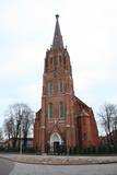 |
Находится в стороне от площади Куршу, ул. Э.Венденбаума, д. 1. Старейшая церковь города, сведения о которой сохранились с 1508 года. Первый храм на этом месте был построен из дерева. После неоднократных перестроек (последняя – в 1893 г. под руководством архитектора Лиепаи Пауля Макса Берчи) храм приобрел теперешний вид в неоготическом стиле с башней высотой около 60 м. Церковный интерьер славится одним из самых выдающихся шедевров времен барокко в Латвии – алтарем (резчик по дереву Николя Сефренс младший), который в 2012 году отметил свое 350-летие.Алтарь считается одной из самых выдающихся работ Восточной Европы того времени. Ретабло алтаря (5,8 x 9,7 м) известно тематическим циклом страданий Иисуса. В храме находится третий по величине орган Латвии, который построен по эскизам композитора и органиста Альфреда Калниньша. Церковь можно осмотреть изнутри и подняться на колокольню. |
|
 |
Teearu farm prepares various dishes from the fish of Lake Peipus; marinated, smoked bream is especially popular. It is also possible to taste meat smoked according to traditional methods. Catering can also be ordered. |
|
 |
A school that was moved from Žocene was here during the 1850s, and it is alongside the Ģipka church. In 1938, a company from Dundaga opened a shop here to sell goods of basic necessity. (Source: Roja TIC) |
|
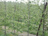 |
One of the loveliest apple orchards in Latvia (~10 ha, 30 types of apples) is on the sides of impressive hillocks. During clear weather, you can see the Bay of Rīga from atop the hillocks. The farm is particularly beautiful when apple trees are in bloom. Apples are available for tastings and purchase. |
|
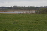 |
Nature restricted area surrounds Tasu Lake and swampy shores of it in a narrow band. The territory was established to protect rare nesting and migratory birds. The territory is easily overseen from the narrow gravel roads all around the area not entering the actual protected area. Tasu Manor house is located to the South of nature restricted area.
|
|
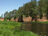 |
This park is in an area which has not been affected much by humankind – sandstone cliffs, an undisturbed diversity of caves, other habitats, species and landscapes is the attractive aspect of this area. The Salaca River is one of the most important rivers in the Baltic Sea region for the spawning of salmon, and it is the second most popular river for water tourists in the Latvian region of Vidzeme. There are geological monuments which are very attractive to visitors – the Red cliffs, Skaņais Hill, the Neļķu cliff, the Velna (Devil’s) cave, etc. There are also cultural monuments such as the Livonian castle hill, the Vecsalaca baronial estate, the Livonian Museum, the Vantenberģi estate, the unique Salaca lamprey weirs, etc. Also in the park is one of the most popular tourist destinations in Northern Vidzeme – the Skaņākalna park, which has a dense network of footpaths. The Salaca is also popular among fishermen. This is part of the Northern Vidzeme Biosphere Reserve. |
|
 |
Kalētu muižas bijušais medību dārzs. Muižas laikos šeit ierobežotās platībās turēja meža dzīvniekus, kuru medības bija populārs muižniecības izklaides veids. Parkā uzmeklējams piemiņas akmens Krievijas imperatoram Aleksandram III, kurš šeit nošāvis briedi (irsi). No Kalētiem Latvijas teritorijā „ienāca” staltbrieži, kurus medību vajadzībām 1848. g. atveda no Vācijas. Parkā izveidotas takas un atpūtas vietas. |
|
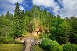 |
Klinšu smilšakmens ieži veidojušies, ūdens straumēm sanesot smilšainas, mālainas iežu daļiņas. Tās lēnām nogulsnējās un sablīvējās, topot par vareniem dabas veidojumiem! Līgatnes pagrabu alas savām rokām radījuši senie iedzīvotāji. Šī neparastā vieta ļāvusi daudzām paaudzēm izdzīvot, jo alās bija iespēja uzglabāt nepieciešamās pārtikas rezerves. Alām ir nemainīga temperatūra, kas padara tās par drošu pārtikas produktu un dzērienu glabātuvi. |
|
 |
Starpiņupīte is an artificial canal
between Lake Kaņieris and the Bay of
Rīga. It helps to regulate the water level in
the lake with a system of locks. This is a
fine place for birdwatching in the spring
and autumn. From the sea, the location
can be identified via the place where the
little river flows into the sea.
|
|
 |
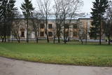
Gebaut am Ende des 18. Jh. im Stil des Frühklassizismus als der Besitz der Grafen von Mellin. Saaldekorationen vom künstlerischen Wert von K. V. Kalopka (1792) und Öfen (Ende des 19. Jh.). Ein Park. |
|
 |
This is an important territory to protect the little gull during spring migration. It is opposite the Salacgrīva, Limbaži, Saulkrasti and Carnikava administrative districts, with a total area of 58,600 hectares.
|
|
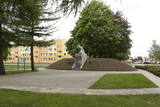 |
The monument is on the side of Rīgas Street in the centre of Piņķi. It is dedicated to May 22, 1919, when, after a pause of nearly two months, a brigade commanded by Col Balodis headed for Rīga to rid the capital city of the Bolsheviks. The brigade was supposed to receive support from the German Landeswehr, the German Iron Division, and the units of Prince Lieven from Russia. The first monument was unveiled by Latvian President Kārlis Ulmanis on May 23, 1939. It was destroyed by the Soviet regime in 1951, but a copy was installed in 2003 (sculptor J. Briedis, copy by O. Skarainis). |
|


