
| No | Name | Description |
|---|---|---|
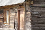 |
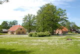
Vāldamõ – a residential building that is yellow and has natural roofing materials. It was built as a new farm at the beginning of the last century. Virgo is the next homestead to the North from Vāldamõ, and it was established as a new farm in the 1920s. The house (1930) features interesting wood carvings. Next to the North is Fīlmaņi, which has a building that appears antique, but was built in the early 20th century as a single roof. Silkalni is the homestead that we find if we turn to the right toward Pitrags at the crossroads. The yellow building was built around 1906 as a single room. Norpiedagi is to the South from Silkalni – a brown and larger house than the previous one. The home was built around 1906 as a one-room granary by the active Liv public activist and boat builder Diriķis Volganskis (1884-1968). His son, Edgars Valgamā, who was also a Liv cultural activist and worked as a pastor in Finland, was born here. Anduļi can be found at the aforementioned crossroads. This is one of the largest old farms in the village, and it is owned by the village elder. The history of the homestead was first recorded in 1680, when it was called Kūkiņi. The homestead includes a residential building (c. 1909), a threshing barn (1905), a granary (mid-19th century), and a smokehouse made of a boat that was cut in two. Under the part of the threshing barn which is on the back of the dune, there is the medieval, so-called Plague cemetery. Žoki is a homestead that is on the other side of the road from Anduļi. The building that is there now was built on the foundation of an older one. In the mid-19th century, Žoki was home to the first reading school for Liv children from the seashore villages of the Dundaga region. Liv Nika Polmanis (1823-1903) worked there as a teacher. Next to the North of Žoki is the Tilmači homestead, with several buildings that were built in the late 19th and early 20th century – a brown residential building, a stable and part of a granary. When the residential building was restored, the owner found a board reading "1825. Kurlyandskaya gubernya." The seven historical homesteads and buildings were at one time considered for listing on the UNESCO list of world heritage. |
|
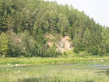 |
One of the most beautiful areas along the Venta River and its tributary, the Šķērvelis River. The river valleys and gullies along them are quite deep, and dolomite and sandstone cliffs can be spotted here and there. There are also rapids on the river. The largest cliffs in Kurzeme – the Ātraiskalns and Gobdziņi cliffs – can be seen on the banks of the Venta. The Lēni Catholic Church is near the restricted area. There are no tourist elements in the restricted territory at this time. The Venta is a popular destination for water tourists, however, from Nīgrande to Kuldīga. |
|
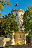 |
Cēsis is in the centre of the Gauja National Park, but it is not part of the park as such. There are many interesting places in Cēsis to visit and examine. The oldest part of the town is of key interest. The origins of Cēsis can be found at Riekstu hill, which is 18 metres high. Between the 11th and 13th century, there was a wooden castle here built by the Vendians. The hill is in the central part of the castle park, and it offers a good view of the park, pond and the ruins of the Cēsis castle, which can be accessed via a long cascade of stairs. The Cēsis castle (see below) was built in the early 13th century as a residence for masters of the Livonian Order, and it was one of the strongest fortresses in the Baltic territories. Alongside it is the New Cēsis castle, which was built in 1777 where the gate fortifications once stood. The Cēsis Museum of History and Art is in the building, alongside which is a visitors centre and the Cēsis Tourism Information Centre. From the tower of the castle, there is a fine view of the castle ruins, St John's Lutheran church and the northern part of the town. Opposite the New Cēsis castle are stables and a wheelhouse (both from the first half of the 19th century). The Cēsis Exhibition Hall is there today. You can look at the exteriors of the granary, the hut for coachmen, and the old brewery. On the other side of the street is the romantic Maija park, which was installed in the 1830s. The park is popular among parents with children, because there is a playground there. From this area, you can walk down some of the old streets of the town – Lielās Katrīnas, Mazās Katrīnas, Mazā Kalēju, Kalēju and Lielā Līvu streets, plus Līvu Square. The wooden buildings along the streets date back to the late 18th and early 19th century. Torņa Street, which weaves its way along the defensive walls of the Medieval castle, offers a look outside the church of a sculpture by Matiass Jansons, "As the Centuries Pass". Legend says that if you rub the lantern carred by the Old Man of Time, you can see the future. One of the most impressive buildings in Cēsis is St John's Lutheran Church, which was built in the late 13th century for the Livonian Order. It is a basilica built in the Roman style and with Gothic elements. The tower, which is 65 m high, was built in 1853. The building was reconstructed several times during the 20th century. Inside the building are grave epitaphs for masters of the Livonian Order and for bishops. The pulpit was installed in 1748, the oak altar followed in 1858, and the altar painting "The Crucified One" dates back to 1862. The stained glass windows around the altar are of great artistic value. The organ was built in 1907 by the E.F. Walker Company, and the instrument is one of the best concert organs in Latvia. A sun clock featuring the year 1744 is at the south-western corner of the church. It is worth climbing the church's tower. At the foot of the building is Rose Square, which began as a market square in the mid-19th century, remained in place until 1927, and was restored in 2008. This is the central square in the town today. During the Medieval Era, there were stockades here, along with the city's well. Rīgas Street has been the main street of the old town from the very beginning, and it is here that you will find the most architecturally outstanding buildings in town from the 18th and 19th centuries. They include the former Cēsis City Hall, the Fābers building, and the Princess building. At one end of the street is Līvu Square, where, during the 13th century, there was a church, a cemetery and a gate in the town walls. Today the square features a lighted fountain which is on the site of a 13th century well known as Lejas Šķimbēgs. At the other end of the street is a reconstruction of the foundations and surface elements of the Rauna gate that was a part of the town walls in the 14th and 15th centuries. The site offers a good idea about Medieval fortifications and the size and mightiness of gates therein. |
|
 |
Piesta Kuusikaru farm is located in Vändra forest, Pärnumaa. We invite everyone who would like to know how this family decided to create their own farm in the countryside and started to make wonderfully delicious products from apples. At the farm you can taste all the products and buy all your favourites to take away. A great place to relax with your family. |
|
 |
Documents show that the first windmill was built here in the 13th century along with the Kuldīga Castle. During the rule of Duke Jacob, gunpowder was manufactured at the windmill, and it later became the first place in Kurzeme where paper was manufactured. The building took on its current appearance during the 19th century. During the Soviet occupation, a metal processing workshop was in it. |
|
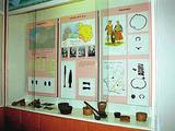 |
Viļāni Museum of Local History. Permanent exposition of the
town history from the ancient times to nowadays. Tours in Viļāni.
Working hours: Mon– Fri : 8.00 – 12.00,13.00 – 17.00, Sat., Sunday : closed |
|
 |
After the death of the Kalnasikšņi oak tree, which was the mightiest tree in the Gauja National Park, the mighty Kvēpene oak tree has taken over that role. It has a circumference of 6.1 m, a height of 20 m, and a crown which measures 28 x 30 m. The beautiful tree is on the right bank of the Gauja River valley and is one of the most excellent trees in Latvia. Near it is the forested Kvēpene castle hill, as is the Svētavots stream, which is reputed to have medicinal waters. To the North of the castle hill is the Rūsiņš hillock, which offers a good view of the surrounding forests, the towers of the city of Cēsis, Ieriķi, and the Rakšupe estuary at the Gauja. There is a bench at the top of the hillock from which lovely sunsets can be seen. |
|
 |
The café is located the Krūziņi guesthouse in the centre of Dundaga. Latvian cuisine: Sauerkraut soup, grey peas with curdled milk, roast perch or cod, sorrel soup with potatoes. Special foods: “A tower of cottage cheese” or crème from the ingredients of the Dundaga Dairy. |
|
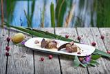 |
Located in the centre of Dikļi, the 1896 castle was renovated into a four-star hotel in 2003. The castle offers a look at antique furnishings, fireplaces and ovens, as well as paintings by Latvian artists. Two restaurants (summer and winter) offer fine dining and an individualised approach. The castle works with local farms. Latvian cuisine: Beefsteak, grilled trout, smoked wild board bacon, filet of pike from Lake Burtnieki, seasonal mushrooms and berries. Special foods: Venison chop, candied fruit in syrup, onion marmalade. |
|
 |
The teahouse is in a lovely location – the southern part of Pilssala Island, near the pedestrian bridge over the Driksa River. |
|
 |
This is one of the most beautiful gardens in Nīca, particularly featuring hostas and maple trees. There are more than 130 varieties of hostas, as well as 25 maple trees. The large pond features fish that can be fed, and visitors will enjoy the beauty of the garden. Guests will particularly enjoy the impressive homestead sign that was created after a long search. The garden has done will in beautiful garden competitions at the level of Nīca and the level of Latvia. |
|
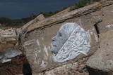 |
The Northern Forts of Liepāja are on the edge of the Baltic Sea, and some parts of them have been washed away. This is a small, but very impressive part of the Liepāja fortifications which once encircled the entire town. The underground bunkers of the forts are on two levels, and it’s worth visiting them in the company of a knowledgeable guide from Karosta (tours are organised from the Karosta prison). There’s a car park alongside the forts. It’s also worth walking down the beach for a distance of around four kilometres to the Northern breakwater. On the shore and in the sea, you’ll see two coastal defence batteries and some pretty impressive views.
|
|
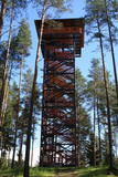 |
Atrodas 6,5 km ziemeļos no Cirgaļiem, P 23 ceļa malā, Ziemeļgaujas aizsargājamo ainavu apvidū. Torni vērts apmeklēt pavasara laikā, kad no tā redzamas applūdušas Gaujas palienes. |
|
 |
Energia (Energy) Farm beside the Navesti River is the largest Estonian company to ecologically grow and process herbs. There is a big herb centre with herbal trails, a modern teahouse, a seminar centre and an eco-spa; the farm’s accommodation features all modern conveniences. |
|
 |
Volzbahs ir stāva nogāze ar elpu aizraujošu skatu pāri gravai. Ziemā šeit pieejams vairāk nekā 100 m garš nobrauciens ar slēpēm, sniega dēli vai ragaviņām. Citos gadalaikos Volzbaha kalns ir lieliska atpūtas vieta- šeit ir labiekārtota vieta piknikam, pastaigām, foto sesijām. Rudenī Volzbaha kalns ir viena no labākajām vietām Vaiņodes novadā, kur vērot krāšņos rudens skatus. Volzbahs atrodas 2 km no Vaiņodes centra ZR virzienā. Kalnam ērti var piebraukt klāt ar automašīnām. Adrese: Vaiņodes pagasts, Dienvidkurzemes novads, LV-3435 Facebook: facebook.com/biedribavolzbahs Twitter: Volzbahs |
|
 |
This territory is meant to protect the “green zone” of Rīga. Most of the park is covered with pine forest and dunes with shrubs on them, but Lake Beberbeķi is found at the southern end of the park. The area around the lake has been improved. |
|
 3 days
|
Маршрут предусмотрен для опытных туристов, кому нравиться объединять наплюдения за природой с познанием культурной среды и истории. Это путешествие по самой впечатляющей речной долине в Балтии – древней долине Гауи. Маршрут начинается в Сигулде, которую с давних пор называют «Видземской Швейцарией». В окрестностях Сигулды открываются одни из красивейших пейзажей в Латвии. Маршрут пересекает глубокие овраги многих притоков Гауи и открывает внушительные в масштабах Балтии обнажения песчаника девонского периода. Природные тропы Лигатне – это единственное место в Латвии, где в условиях, максимально приближенных к естественной жизни в природе – в широких вольерах – можно увидеть разные виды диких животных. Поселок бумажной фабрики Лигатне – это великолепный пример индустриального наследия европейского масштаба со своеобразной средой поселка 19-го – 20-го веков. Цесисский средневековый замок – это мощная крепость средневековой Ливонии с современным центром для посетителей. Конечный пункт маршрута в Валмиере, одном из старейших городов Латвии. Информация о маршруте от Latvijas Lauku forums |
|
 |
Piemājas saimniecība "Rudā lapsa", kas atrodas Ludzas novadā, interesentiem piedāvā iespēju iepazīt laukus, apskatīt mājdzīvniekus, saklausīt dabu, ļauties mierīgai atpūtai. Tiek piedāvātas telšu un piknika/ugunskura vietas. Ciemos tiek gaidīts katrs, kas vēlas atpūsties un izrauties no ikdienas skrējiena. |
|
 |
The “Strand” Complex – it was the largest and most luxurious recreational complex in Neibāde. It consisted of three buildings, a dance pavilion and a park. Only one building of the hotel, the same as what was once Saulkrasti outpatient clinic at 17 Ainažu Street, has survived until nowadays. |
|
 |
The Turaida Museum Reserve is found at the place where the deep gullies of a number of small streams split up the right bank of the ancient Gauja River valley. The Turaida Museum Reserve features monuments of Baltic importance, and their history dates back more than 1,000 years. Among the treasures are the Turaida Estate (21 buildings), the grave of the Rose of Turaida, the Turaida Lutheran Church (one of the oldest wooden churches in Latvia, 1750), and the Turaida Castle. Nearby is Folk Song Hill, where various thematic events are organised. |
|


