
| No | Name | Description |
|---|---|---|
 |
SIA “Rundāles Dzirnavas” 2021. gadā īstenoja projektu, lai izveidotu nelielu alus darītavu un uzsāktu alus ražošanu Rundāles ūdensdzirnavu teritorijā. Tiek ražots gaišais un tumšais alu, kura visas sastāvdaļas tiek iepirktas Latvijā, bet graudi no vietējiem zemniekiem. Videi draudzīgā iekārta atbilst jaunākajiem ES standartiem un prasībām. Latvijas un ārvalstu tūristiem ir iespēja apvienot Rundāles pils apskati ar vēsturisko dzirnavu muzeja un alus darītavas apmeklējumu. Kompleksa teritorijā ir daudz iespēju daudzveidīgai interesantai laika pavadīšanai. Vienas dienas laikā var apmeklēt aizraujošas ekskursijas pa dzirnavām un alus darītavu, pastaigāties pa vietējiem, tuvējiem apskates objektiem, uzņemt lieliskas fotogrāfijas, atpūsties pludmalē un vizināties ar laivu, katamarānu, SUP dēli. |
|
 |
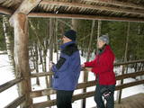
The farm produces mixes involving seeds from various plants – ones which are very healthy in terms of human nutrition. Visitors will hear stories, purchase products and taste hemp pancakes. The tour takes place at the “Mazais Ansis” saloon. |
|
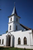 |
The Ilūkste Roman Catholic Church is to the North of Unity Square. The first stone church in Ilūkste was financed by the Plater-Sieberg dynasty of noblemen between 1754 and 1769. The current church was built in 1816. In 1861, it was taken over by the Orthodox Church, but it was returned to a Catholic congregation in 1920. The church was restored in 1921. The interior can be viewed during worship services. |
|
 |
This exhibition features the Pļaviņas hydroelectric power plant as a unique architectural building with unique engineering elements. It is the largest producer of electricity in the Baltic States and one of the largest in
|
|
 |
Das heute gesehene Ensemble (im Stil des Neorenaissance gebautes Gutshaus) entstand im wesentlichen in der Zeit zwischen 1897 – 1902 als ein Eigentum vom Grafen Joseph Tyszkiewicz und seiner Frau. Ein Park. |
|
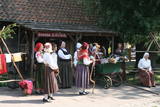 |
2003.gada decembrī folkloras kopa „Atštaukas” izveidoja folkloras centru „Namīns”, kurā svin svētkus, organizē Jāņu ielīgošanu, Lieldienu iešūpošanu, Miķeļdienas tirgu, Annas dienas Saimnieču svētkus, tautiskos Ziemassvētkus. „Atštaukas” palīdz saglabāt un popularizēt dažādus latviešu tautas godību rituālus, gan kāzu, gan arī bēru tradīcijas. Folkloras centrā „Namīns” darbojas arī skola, kurā bērniem tiek mācīta folklora un tautas tradīcijas. |
|
 |
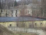
The former Soviet communications division at Plāņciems in the forests of Bārta is privately owned and is being dismantled at this time.
|
|
 |
Lots of wild animals can be found in vast paddocks along the ancient Gauja river valley and its small tributaries – areas in which living conditions are as close to natural circumstances as possible. Here the visitor can find, if lucky, reindeer, deer, wild boars, bears, foxes, lynx, various kinds of birds, as well as aurochs. There is a dense network of pathways in the park, including lots of information. There is also a route for drivers and bicyclists. During the winter, it is used for distance skiing. There is also a visitors’ centre.
|
|
 |
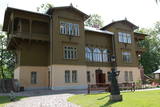
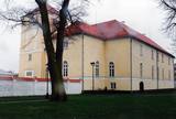
This manor is a prime example of classical architecture in Estonia. Since 2002 Saku manor is also a recreational centre. |
|
 |
On the banks of the Venta River is a treasure of wooden architecture – the so-called Bangerts Villa, which relates to romantic stories and legends and was recently restored. It is said that a man known as Captain Bangerts bought the villa as a gift to present to his Parisian bride. The Kuldīga Administrative District Museum has been in the building since 1940. Since reconstruction, unique wall paintings and other interior design details have been restored, and the flat of the Bangerts family allows people to see how wealthy residents of the city lived in the early 20th century. Also on display are some of the sets of playing cards that have been collected by Jānis Mētra. |
|
 |
The farm "Kronīši" is located in Viļķenes Parish, Limbažu County. The farm grows organic vegetables that are processed into various home preserves. Teas are produced from plants collected from organic meadows, jams, preserves, syrups and juices are also on offer. Fruits and berries are collected from the garden itself, as well as from local farmers and the nearby Rūstuži and Blome marshes. The farm welcomes tourists and exchange groups with prior application. For family events, incl. a teahouse is available for children's parties, creative workshops and other activities. Offers tours with Soviet-era cars and retro cars. |
|
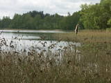 |
Vairākas salas Zvirgzdenes ezerā, uz kurām saglabājušies platlapju (ozolu, liepu) meži ar bagātīgu zemsedzes floru. Salas var redzēt no ceļiem, kas piekļaujas ezera ziemeļu un austrumu krastam. |
|
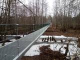 |
The bridge across the Irbe river so that bicyclists and pedestrians can cross the bridge where the former tram tracks were located. |
|
 |
The idea of the centre is to strengthen health by using clean food, so here you can enjoy delicious meals from slightly processed, vitamin-rich foods. The centre mainly uses fresh products from the garden of the centre and local farms. The specially developed menu plans consist of delicious vegetable soups and stews, as well as various porridges. Healing cures include not only certain meals, but also treatments and workouts that must be ordered in advance. |
|
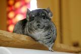 |
The owner of the farm offers attractive tours during which you will learn about chinchillas, animal enclosures, as well as quails which you can view and purchase. |
|
 |
Musteikas pirmsākumi ir meklējami jau 18. gs. Līdz Musteikai no Marcinkones puses var nokļūt pa grantētu ceļu, kas ved gar bijušajiem kolhoza zivju dīķiem. Automašīnu var atstāt ciema sākumā un izstaigāt to ar kājām, izjūtot veco ēku smaržu un šarmu. Musteikā atrodas Dzūkijas biškopības vēsturei veltīts „dzīvs” muzejs, kur stropos dzīvo bites, bet tā saimnieks ir biškopis pēc aicinājuma un būtības. Ja palūgsiet, viņš demonstrēs – kā ar krama, metāla un posas piepes palīdzību senos laikos ieguva uguni. |
|
 |
Laila Kelle works in a building of the former Lamiņi semi-estate. She teaches drawing and painting of landscapes and still life paintings, using oil paints for this purpose. Nature trail (3km).
|
|
 |
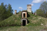
The Swedish army built a modern fortress during the 1640s with five bastions and two gates. There were 120 cannons and mortar throwers, barracks for soldiers, flats for officers, a garrison church and warehouses for food at munitions. After the Great Northern War in 1710, the fortress was taken over by the Russian army. After the Soviet occupation in 1940, the Soviet navy took over the fortress. Alongside it is a former Soviet army facility with abandoned buildings and a monument to sailors who served in submarines. The fortress is open for tours on Saturdays and Sundays. |
|
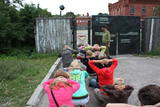 |
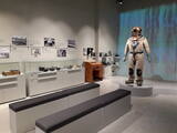
The Karosta prison cannot be described, it must be experienced and survived. That’s an opportunity for everyone. This is the best example in Latvia as to how the military heritage can be used for tourism purposes. Others can learn from this site. |
|
 |
The Castle of the Livonian Order in Ventspils was first listed in documents in the late 13th century, and despite damaging wars, it has maintained its essence as a castle to this very day and only with minimal changes. The castle is also known as the oldest Medieval fortress in Latvia. Today it is home to a modern museum. |
|


