
| Нo | Название | Описание |
|---|---|---|
 |
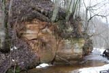
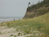
The cave, which is 45 m deep and up to 5.5 m wide is found on the right bank of the Strīķupe river, by the Cēsis-Lenči road. The cave and its nearby sandstone cliff have suffered much damage from local visitors, which is why the administrators of the national park limited access to the surrounding territory a few years ago. You can no longer approach the cave. This is a positive example of who an important geological monument and a protected biotope can be protected. |
|
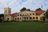 |
Atrodas 0,9 km ziemeļrietumos no Dzērbenes centra. Tagadējais muižas komplekss veidojies 14. gs. celtās un 1577. g. nopostītās mūra pils vietā. Muižas pils (18. gs. beigas, klasicisma stils) savā pastāvēšanas laikā piedzīvojusi vairākkārtīgu nopostīšanu (1905. g., Pirmajā pasaules karā) un tai sekojošu atjaunotni. 19. gs. beigās tai tapa piebūve – iespaidīgs četrstūru neogotikas stila tornis. Laikā no 1927. - 1975. g. pilī darbojās lauksaimniecības skola, tagad - Dzērbenes pagasta pārvalde, Tautas nams un mūzikas skola. Pili ieskauj parks ar septiņu dīķu kaskādi. No kādreiz iespaidīgā laukakmeņu žoga saglabājušies vien pils vārtu stabi. Dažādā stāvoklī (arī avārijas) atrodas citas muižas ēkas. 2010. gadā tika veikta pils iekštelpu un ārējās fasādes restaurācija. Iepriekš piesakoties, tiek piedāvāta gida vadīta ekskursija un piedzīvojums muižā iekārtotajā spoku kambarī. |
|
 |
Ja mērķis ir savākt pilnvērtīgu etnogrāfisko ciemu fotokolekciju, ir jāapskata Strazdi (no lietuviešu valodas strazdai tulkojumā nozīmē strazds), kas ir pavisam neliela apdzīvota vieta Balošas (Baluošas) ezera ziemeļu krastā. Strazdi pirmoreiz rakstos minēti 1783. g. un ciema nosaukums cēlies no kādas mežziņu dzimtas uzvārda. |
|
 11 дней
|
Маршрут начинается с поездки на поезде из Риги в Лиепаю, город с белыми песчаными плюжами и оживленной культурой уличных кафе. Маршрут проходит через пригороды Лиепаи в бывший военный город, где вы увидите православную церковь, старинные морские фортификационные укрепления,бывшие бараки и внушительную военную тюрьму, которая сейчас является туристическим объектом. Павилоста — небольшой прибрежный город и любимое место среди виндсерфингистов. Затем маршрут проходит вдоль живописного побережья, включая крутые берега Юркалне, и заканчивается в содержащемся в идеальном порядке городе Вентспилсе. Затем отправляйтесь вдоль рыбацких деревень, являющихся местом жительства для очень маленькой этнической группы финно-угров, ливов. На мысе Колка Балтийское море встречается с Рижским заливом. Здесь вы просто обязаны отведать рыбы местного копчения. Далее маршрут пересекает три различных типа морского побережья — каменный пляж в Калтене, песчаный в Упесгриве и прибрежные луга в Энгуре. Заканчивайте маршрут в Национальном парке Кемери и возвращайтесь в Ригу через популярный курорт Юрмалу. |
|
 |
Организуется эдукационная программа «Дружелюбный мясной скот – не только пища, но и радость общения», во время которой посетители могут близко ознакомиться с мясным скотом, узнать о специфике их выращивания и разведения, а также о пользе, предоставляемой деревне и природе. |
|
 |
Pitas ir pēc inovatīvas žāvēšanas tehnoloģijas radītas augļu, ogu un garšaugu garšvielas, kuras ražo mājražotāja Lorita Miķelsone. Mājražotāja labprāt ļaus nodegustēt un iepazīstinās ar Pitām jebkuru interesentu, uzņemot apmeklētājus Skaisto un praktisko ideju dārzā Dobelē. |
|
 |
It is worth hiking this road where in crosses the Šlītere Blue Hills. This part of the road is approximately one kilometre long, and it goes down to the valley of the stream which crosses the hills. The place has been given a peculiar name – the Kušperlankgrāvis ravine (or the Zeltiņi ravine, as is claimed in other sources). If you're driving, be careful, because there is no bridge here, just a ford. During the early spring or the winter, you will appreciate the ravines and the impressive Blue Hills themselves. Impressive sandstone cliffs which are several metres high and have been vandalised by human hands are on both sides of the road. There is a small niche in one of the cliffs. To the right (East) from the road at the terrace of the Blue Hills is a side road which leads to the Mežlīdumi homestead. Please be gentle with the cliffs! |
|
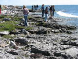 |
The national park was established to protect the 100 or so small islands that make up the archipelago of the local area. The largest island, the Vilsandi Island, is 6 km long and up to 2 km wide. You can rent a boat to get there, or, during appropriate conditions, you can walk across the sea and the small islands from the southern end of the Kuusnõmme peninsula.
|
|
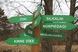 |
Кошрагс считается самым молодым из ливских прибрежных селений (образовалось в 17-ом веке). В 1826 году в Кошрагсе было 78 жителей. В 1832 году в Жоках была открыта первая в приморских деревнях Дундаги школа чтения для ливских детей, где учителем работал первый получивший профессиональное образованние представитель ливов Ника Полманис, который перевел Евангелие от Матфея на восточный диалект ливского языка. В Кошрагсе была ветряная мельница, водяная мельница, судоверфь. Весной сюда причаливали лодки с ищущими работу эстонцами с острова Сааремаа. В 1932 году здесь был построен порт, в 1938 году – мол (волнорез) для сбора морской грязи. В 30-е годы прошлого века Кошрагс регулярно посещали финские и эстонские лингвисты, которые собрали здесь наибольшее количество единиц ливского фольклора. Дом Норпиедагу строил общественный деятель ливов – Дидрикис Волганскис (1884-1968). Там родился его сын – деятель культуры ливов, священник (в Финляндии) Эдгарc Валгама (Волганскис, 1912-2003), который перевел эпос A.Пумпурса «Лачплесис» на финский язык. В настоящее время Кошрагс является национальным памятником культуры. |
|
 |
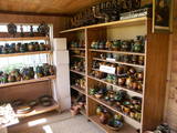
В Центре ремесленничества, что находится на территории бывшей господской усадьбы «Светес», проводятся творческие мастерские. Здесь можно купить уже готовые керамические изделия, а также сделать индивидуальные заказы. |
|
 |
В Усадьбе громкой тишины («Garsios tylos sodyba»), что стоит на склоне старицы реки Нявежис, производят «счастливую еду» из выращенных здесь же продуктов. |
|
 |
The so-called Comet Fort was built on the Left Bank of the Daugava at its mouth, not far from the present Daugavgrīva lighthouse. It was built around the same time as the other forts of Mangaļsala (around 1808, although some sources say 1788). There were four Kane-type 152-mm cannons. The defensive batteries at Komētforts and Mangaļsala repelled a British naval attack in the Daugava estuary in 1855. It has to be added that Komētforts is a cultural monument of local importance. If we go along the shore of the sea from the Daugavgrīva nature reserve toward the Daugavgrīva lighthouse and scale the frontal dunes (without going past the sign which says “Closed Territory. Border Zone.”), then we can see the positions of the cannons, as well as underground cellars where munitions were once stored. The territory starts approximately 500 metres before the Daugavgrīva lighthouse and stretches to the lighthouse itself. During Soviet times, the territory was closed to civilians, because many secret military objects were in this area and in Bolderāja.
|
|
 |
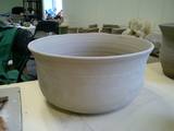
The workshop offers ceramics products. You can watch the potter at work and try your own hand at the craft. You are also welcome to attend the opening of the kiln. |
|
 |
The Ziemupe nature restricted territory is on the shore of the Baltic Sea, and it protects a wide variety of coastline biotopes. The distinguished grey dunes are found here, as are various kinds of forest biotopes, some of them quite rare in Latvia. There are many protected plants and animals in the area, too. The Akmensrags lighthouse and several tourist accommodations, like camping Laikas who "Sējējs" award, are in the territory. On the sea shore not far from center of Ziemupe there is well-appointed parking area with information stands. |
|
 |
This park is located along the shores of the Tērvete River Valley. It is a vast forested area which has been adapted successfully for travellers. In 2004, it was nominated as the most family - friendly destination in the land. There is a web of trails for one-day hikes. Viewing tower on the shore of the Tērvete River, views also from the Tērvete castle hill and Zviedru (Swedish) Hill.
|
|
|
|
Pie Melekiem sākas dabas lieguma teritorija. Meleku
krastmala būtiski mainījās 2005. g. orkāna laikā.
|
|
 2 days
|
Latvia is the land of apples, so producing cider here is only natural! The ancient traditions of apple growing in our country, as well as the variety of high-quality apple cultivars, are key advantages of Latvia's cider culture. In our climate zone, it is challenging to grow good grapes for wine production, but the local conditions are particularly suitable for making apple cider. This is a natural consequence that local cider producers are increasingly mastering with excellence. The Cider Route will take you to various cideries in Latvia, as well as to restaurants and pubs that serve it. The Cider Route allows you to understand the specifics of Latvian cider, introducing you to the culinary traditions and cultural heritage of different regions. You will have the opportunity to meet the cider makers themselves, who run small farms, tend to the orchards, share about their work, and even let you participate in it. |
|
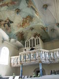 |
The Apriķi Lutheran Church is, for good reason, known as one of the most beautiful churches in Kurzeme. It was owned by the Osten-Zacken dynasty in the past, built in the 17th century, and rebuilt in 1710. The wooden interior is in the Rococo style with elements of the Baroque, and it dates to the mid-18th century. It is amazingly ornate. The beautiful ceiling paintings, which were produced by a Prussian painter called Rode, were painted between 1744 and 1746. |
|
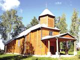 |
St. Anthony Roman Catholic Church of Pilcene (Piļcine) is the oldest wooden church in Latgale, built
in 1670. It is prominent because of its half columns, hexagonal tower, semicircular windows, and a dome
with a cross and antique interior.
|
|
|
|
Veselībai un pilsētvidei draudzīga transporta – velosipēda lietotāji putnu vērošanas torni var sasniegt pa Ķengaraga promenādes veloceliņu. Tornī izvietoti putnu attēli, kas nezinātājiem atvieglo ūdensputnu vērošanas un atpazīšanas procesu. Redzamas plašas Daugavas ainavas. |
|


