
| No | Name | Description |
|---|---|---|
 |
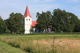
Eine einzigartige Kirche mit einem im 17. Jh. beiseite gebauten Glockenturm. |
|
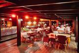 |
The restaurant is at the edge of the Vidzeme Highway (A2). It is a lovely log building with a straw roof and an antique interior. Dishes are based on ancient traditions merged with the requirements of modern clients. Latvian cuisine: Cold soup, dumpling soup, grey peas with bacon, wheat grain porridge, lampreys in mustard sauce, pike-perch grilled on coals, roast pig’s ear, roast pork leg, chicken livers in a creamy sauce, stacked rye bread, cottage cheese dessert with cranberry sauce. |
|
 |
Visitors are welcome to this ecological cattle farm to learn about its history and operations. The farm offers the "Aubraki" breed of cattle, oats, spelt and forest berries. You can buy fresh and aged beef that is ecological, as well as the berries. |
|
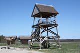 |
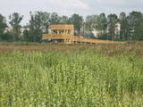
This barrow is on the western side of the Dunduri meadows and was built on the parking lot of the former collective farm. From the second level of the tower, you will have an excellent view of the meadows all the way to the Džukste River and the Kauguri canal. There are livestock accustomed to life in the wild, although they will sometimes be quite distant. This is a bird-watching location from the springtime until the second half of the summer. |
|
 |
Das Museum befindet sich in der Festung von Kopgalis. Im Aquarium des Museums sind Fische und Tiere der Ostsee und anderer Meere und Ozeane zu sehen. Eine Ausstellung. Pinguine und Seehunde. In den Pulverkellern der Festung ist eine Ausstellung der Seefhrt Litauens, aber auf den Bollwerken eine Ausstellung der Gewehr eingerichtet. Das einzige Delfinarium im Baltikum. |
|
 7 days
|
The most spectacular autumn events are the Crane shows which can be observed at the bogs and fields. The tour will pass several of these places. We have included different biotops in the tour- seacost, different forests, bogs and fish ponds- in order to see various bird species. |
|
 |
This was an island after the Rīga hydroelectric power plant created a reservoir, and before that it was a peninsula on the Left Bank of the Daugava. During World War I, there were massive battles between Latvian Riflemen and a much larger German army on Death Island. On December 25, 1916, the Germans used poisonous gas against the Latvian troops. In honour of this, the architect Eižens Laube designed a monument to fallen Latvian riflemen on the northern shore of Death Island. It was unveiled in 1924. Death Island can be reached by boat, and the trenches and graves there are of interest. There is a pier for boats on the north-western shore of the island, and nearby is a location for leisure. Some of the trenches and dugouts have recently been restored. The battles were described by Aleksandrs Grīns in his masterpiece, “Snowstorm of Souls.” |
|
 8 days
|
Saaremaa and Hiumaa are the two largest ones amongst 1500 other Estonian islands. In fact Saaremaa is the common name for Muhu and Saaremaa islands which are connected by the causeway like Hiumaa and Kassari islands. |
|
 |
When you drive down the Nereta-Ilūkste road, the church, which was built in 1805 and restored in 1888, can be seen from a distance. The altar, pulpit and organ prospectus are all original. German soldiers who fell during World War I are buried outside of the church. Two plaques on the western wall of the building honour residents of the Laši Parish who died during the First World War, as well as those local residents who suffered Soviet repressions. |
|
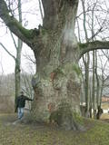 |
This tree is in the park of the Sēja Estate and is one of the four trees in Latvia that have a circumference of more than four metres.
|
|
 |
Atrodas galvenās Kuldīgas gājēju ielas malā. Sadarbojas ar vietējiem zemniekiem un piedavā Kurzemes novadam raksturīgus ēdienus, kā arī ēdienus no dažādu pasaules valstu receptēm. |
|
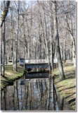 |
Vēršupīte is a small river which curves through the
town of Ķemeri and has more than 10 small and
romantic bridges across it – each with its own name.
|
|
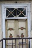 |
Ein schönes Holzhaus (Baznīcas ielā 7), gebaut 1670 an der sogenannten Venedig-Brücke in Kuldīga über den Fluss Alekšupīte. Auf dem Dach des Hauses befindet sich eine der ältesten und schönsten Windfahnen der Stadt. |
|
 |
Rokdarbniece Vineta Meistere piedāvā apskatīt, pasūtīt un nopirkt gleznas, dienasgrāmatas un recepšu grāmatas, kas izšūtas krustdūriena tehnikā. |
|
 1 day
|
This tour is suitable only for experienced hikers. The itinerary circles the Suurupi Peninsula where the dense forests conceal the military heritage of different eras. The Baltic Coastal Hiking Route meanders through overgrown and rocky seacoasts, birch groves, along former pioneer camps and sand-stone cliffs protecting coves with sharp capes. At the end of the itinerary, one of the most astounding outcrops of the Estonian littoral rises before your eyes – the Rannamõisa Cliffs, which gives views of Kakumäe Bay and Peninsula and the towers of Tallinn’s Old Town |
|
 |
The farm is open to visitors all year round, but the best time to visit is during the spring and summer. The farm offers 45-minute lectures about plants, after which there is a 30-minute tour of local plants outdoors. |
|
|
|
Labiekārtota (informācijas stendi, atpūtas vietas) un marķēta taka, kas ved apkārt Kokšu ezeru virknei, kurā ietilpst Zāļu, Dziļais un Dibena ezers. Iepazīstami mežu biotopi, dzīvnieki un to darbības pēdas. Iespējami trīs dažādi takas izziešanas varianti: 7 km, 4,5 km, 2,7 km. Maršrutu var braukt ar divriteni. Ietilpst Ziemeļvidzemes biosfēras rezervātā. |
|
 7 days
|
Этот маршрут предлагает вам отличную возможность посетить самый большой остров Эстонии – Сааремаа, который является своеобразным символом для туризма по Эстонии. На острове находятся один из наиболее впечатляющих метеоритных кратеров в Северной Европе, Епископский замок Курессааре, самая крутая отвесная скала в Эстонии и множество других интересных туристических объектов. |
|
 |
Ja no Pervalkas (Pervalka) pa Kuršu jomas krastu ar kājām (neliela taka) dosimies Klaipēdas (ziemeļu) virzienā, pēc 10 – 15 min gājiena nonāksim līdz Arkļu ragam (Arklių ragas, citās kartēs – Žirgų ragas), kam iepretim ~ 0,2 km attālumā no krasta uz mākslīgi veidotas akmeņainas salas slejas 14 m augstā bāka. Tā celta ~ 1900. g. vietā, kur savienojas trīs kuģu ceļi no Klaipēdas, Nidas un Ventes raga (Ventės ragas). No šejienes paveras fantastisks skats un Nagļu dabas rezervāta iespaidīgajām kāpām. |
|
 |
This is one of the most interesting protected territories in the city of Rīga, and its aim is to protect coastline biotopes – dune and coastal meadows and the birds and plants which are found there (among them, 29% of the species of orchids). There is a marked information trail with a bird-watching tower. This is the only outdoor viewing tower in Latvia that has been adapted for the needs of people in wheelchairs.
|
|


