
| No | Name | Description |
|---|---|---|
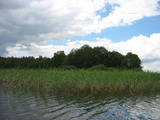 |
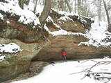
Of the many islands in Lake Rušons, ten are restricted natural areas so as to protect the broadleaf forests which are on the islands and the endangered plants found therein. An ancient cult location – the Rušons Sacrificial Rock – is found on Upursala island.
|
|
 |
The cafe Baravika is situated in the centre of Rezekne city. It offers a wide variety of dishes. Working hours: Mon-Fri 8.30 līdz 18.00 |
|
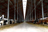 |
AS Agrofirma Tērvete is the largest multi-sector farming company in Latvia, operating in crop farming, dairy farming, horse breeding, public dining, biogas manufacturing and brewing of beer. Visitors can tour a brewery and the farm. The brewery produces popular Tērvete beer and kvass. Visitors can taste the products and take a small tour of the facilities. All of the types of beer can be tasted with delicious snacks. The Tērces farm is a dairy farm with modern technologies and 3,000 dairy cows. Visitors can tour the facility and have lunch at the company’s dining hall. |
|
 3 days
|
Это один из 6 маршрутов путешествий в серии «Насладитесь деревней!», который приглашает Примерное время прохождения маршрута: четыре – пять дней, в зависимости от количества выбранных достопримечательностей и времени, отведенного для их осмотра. |
|
 |
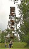
Jēsū – Kepu ceļa malā pie Leti (Läti) ciema ir izveidots autostāvlaukums ar putnu vērošanas torni, no kura paveras skats uz Hallistes upes palieņu pļavām un tuvējā ciema apkārtni. Stipru palu laikā arī no šī torņa redzamā apkārtne (izņemot ceļus) var atrasties zem ūdens. Laba putnu vērošanas vieta. Läti tulkojumā no igauņu valodas nozīmē Latvija. |
|
 |
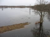
This is an artificial body of water that was dug in the 1960s to obtain ice for fish processing plants in Kolka. |
|
 |
Atrodas Raganas centrā pie degvielas uzpildes stacijas, viesnīcā „Raganu ligzda”. Piedāvā mūsdienīgu Latvijas virtuves ēdienkarti. Kompleksās pusdienas. Sadarbojas ar vietējām zemnieku saimniecībām. |
|
 |
Saimniecība nodarbojas ar tīršķirnes trušu audzēšanu, papildus tam audzē arī dažādu šķirņu mājputnus. Saimniecībā var apskatīt trušus, mājputnus, eksotiskos putnus, murkšķus, aitas, kazas, pudurkzas un punduraitas. Visi dzīvnieki izvietoti divos norobežotos voljēros, kur nesteidzīgi var apskatīt dzīvniekus, uzdot interesējošos jautājumus saimniekam. Pēc pastaigas ir iespēja sarūpēt sev maltīti ugunskura vietā un atpūsties lapenē. |
|
 |
The Ferris wheel that is in Sigulda is on the corner of Leona Paegles and Cēsu streets, and it is only open during the summer. If you ride the wheel, you can take lovely snapshots of the ancient Gauja River valley. |
|
|
|
Atrodas Sedas purvā (Sedas dabas takas malā) ar plašu skatu uz izstrādātajām kūdras platībām. Sedas taku ieteicams izstaigāt vietējā gida pavadībā T: + 371 2636162. |
|
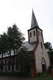 |
Atrodas pie Līvānu dzelzceļa stacijas, Dzelzceļa ielā 17. Tā kā Līvānos nebija luterāņu baznīcas, draudze dievkalpojumus noturēja ugunsdzēsēju depo. 1929. gadā ielika dievnama pamatakmeni un pēc trīs gadiem pabeidza pašas ēkas celtniecību. Saglabājušās ziņas, ka padomju laikā baznīcā bija plānots iekārtot sporta zāli un noliktavu, taču tas neticis īstenots. Jāpiemin, ka baznīca ir celta uz bijušās korķu fabrikas pamatiem. Dievnama zvana iegādei līdzekļus sarūpēja kara ministrs – ģenerālis Jānis Balodis u.c. |
|
 |
There is a small and relatively hard to reach area on the western shore of Lake Būšnieks which has been restricted to protect swamp habitats and several protected plants. Boat base is on the northern shore of the lake offers boat rental. From the plank-way good sites of eutrophic part of Lake Būšnieks can be seen. A well-appointed recreational facility (not included in the restricted area) is on the opposite shore of the lake. |
|
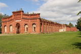 |
This building was erected in 1903 and 1904 to be used for military training, exercises and ceremonial events. An addition to the South of the building held a small church, but it is gone. The building was used for gymnastics performances and competitions for horseback riders. Official meals for the garrison’s sailors were held there, too – the hall could hold up to 3,000 people. Only the outer walls survive today, sad to say. You can view the exterior and interior of the hall at any time. This is the only building of its size and type in Latvia. The roof once had bands of glass tiles.
|
|
 |
This is a view worth a journey from a distance. This is an impressive terrain for Latvia, and here you will see as far as the Hanja highlands of Estonia, where the Great Munameģis Hill – the highest surface in the Baltic States – can be found.
|
|
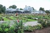 |
This botanical garden was opened in 1923 as a scholarly centre. The garden covers more than 60 hectares, and approximately 30 ha are open to the public. |
|
 |
Lielais Liepu kalns ir Latgales augstienes Rāznavas pauguraines augstākā un Latvijā trešā augstākā virsotne (289,3 m v.j.l.). Lielpaugura relatīvais augstums ir 86 m! Skatu torņa platforma ir šobrīd augstākais Latvijas punkts (323 m.v.j.l.), kas sasniedzams ar paša kājām! Liepu kalna apkārtne ir labiekārtota. |
|
 |
The so-called Comet Fort was built on the Left Bank of the Daugava at its mouth, not far from the present Daugavgrīva lighthouse. It was built around the same time as the other forts of Mangaļsala (around 1808, although some sources say 1788). There were four Kane-type 152-mm cannons. The defensive batteries at Komētforts and Mangaļsala repelled a British naval attack in the Daugava estuary in 1855. It has to be added that Komētforts is a cultural monument of local importance. If we go along the shore of the sea from the Daugavgrīva nature reserve toward the Daugavgrīva lighthouse and scale the frontal dunes (without going past the sign which says “Closed Territory. Border Zone.”), then we can see the positions of the cannons, as well as underground cellars where munitions were once stored. The territory starts approximately 500 metres before the Daugavgrīva lighthouse and stretches to the lighthouse itself. During Soviet times, the territory was closed to civilians, because many secret military objects were in this area and in Bolderāja.
|
|
 |
Pirms dodamies tālāk – Skaistkalnes virzienā, var izmest nelielu loku līdz Lejeniekiem, kas atrodas skaistā vietā – Mēmeles kreisajā krastā, 6 km austrumos no Bauskas. Latviešu dzejnieka Viļa Plūdoņa (1874. – 1940.) memoriālais muzejs dibināts 1968. g. viņa dzimtajās mājās „Lejeniekos”. Zemgales daba un vecmātes stāsti būtiski ietekmēja nākamā dzejnieka daiļradi. Šeit nokļuvušie var apskatīt ratu un etnogrāfisko priekšmetu kolekciju, izstaigāt Plūdoņa taku vai apmeklēt dzejnieka un viņa radinieku atdusas vietu netālu esošajos kapos. Bērniem noteikti jāiegriežas “Zaķīšu pirtiņā”. |
|
 |
The Kaļķupe River valley was established as the Pilsupe River (formed by Kaļķupe River and Mazupe River) crossed the Blue hills of Šlītere to the South of Vīdale and Kaļķi. The distinct river valley has a branched network of gullies in which Devonian sandstone has been uncovered and can be seen in some locations. Puiškalns Hill (located at confluence of Kaļķupe River and Mazupe River), which was used as a castle hill and as a sacred location long in the past, is one of the most distinctive parts of the area. It is a popular tourist destination in the Talsi District. Hillside forests, various kinds of meadows and a wide range of plants are also of value in the local environment. |
|
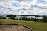 |
This park is located in the northern part of the Žemaitija Highlands, and much of it is taken up by Lake Plateliai. The park was established to protect lakes, rivers, wetlands and forest ecosystems, as well as the local cultural environment.
|
|


