
| No | Name | Description |
|---|---|---|
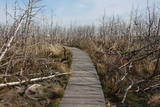 |
Nahe der Beerkopfdüne ist im Frühling 2006 „ein Brand der Jahrhunderte” gewessen. Es wurde der hundert Jahre alte Wald in der Fläsche von 235h ausgebrannt. Ein Pfad mit Holzbelag. |
|
 |
Gebaut am Ende des 18. Jh. im Stil des Frühklassizismus als der Besitz der Grafen von Mellin. Saaldekorationen vom künstlerischen Wert von K. V. Kalopka (1792) und Öfen (Ende des 19. Jh.). Ein Park. |
|
 |
Kafejnīca "Dižjūra" atrodas Mazirbē, Lībiešu tautas namā. Atvērta vasaras sezonā. |
|
 |
Interesantā būve, kurai Baltijas valstīs grūti atrast līdzinieku, ir meklējama 2 km ziemeļaustrumos no Kirblas (Kirbla). 307,8 m garo arkveida tiltu pāri Kazari upei (Kasari jõgi) uzcēla 1904. g. deviņu mēnešu laikā. Tajā brīdī to uzskatīja par Eiropas garāko šāda tipa dzelzsbetona tiltu. Tagad to var šķērsot tikai ar kājām vai ar divriteni. Tumšajā diennakts laikā tilts ir skaisti izgaismots! Tā ievērojamais garums ir skaidrojams ar apstākli, ka pavasara palos Kazari palienes applūst lielās platībā. |
|
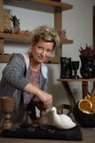 |
This is one of the few craftswomen in Latvia who does not use a potter’s wheel in her work. Instead she works in the “snail” or “sausage” technique that was typical of the Bronze Age. Her artworks are distinguished by a diversity of form and functionality. Children can attend master’s classes. You can take tours, take part in the opening of the kiln, and purchase fumigated ceramics products. |
|
 |
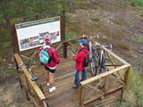
An important complex of the coastline and its sand dunes along with the mouths of three major rivers – the Lielupe, the Daugava and the Gauja. This area has ancient traditions of recreation and spa services. The territory has lovely shoreline landscapes and features one of the few coastline meadows in Latvia. The nature park includes several restricted areas – the meadows of the Lielupe estuary, Vakarbuļļi, Daugavgrīva, Vecdaugava and Ummis (see the section on “Restricted Natural Areas”). Interesting elements of nature in this area include the amphitheatre of the Garciems dunes, along with individual dunes such as the Legzdiņi dune and the so-called ski mountain dune. Visitors will be attracted by various cultural and historical monuments – fortifications on the Mangaļi peninsula, military buildings from the period of the Russian tsars all the way through the late period of the Soviet occupation, the fortress of Daugavgrīva, the Vecāķi spa with its old shoreline buildings, and the beaches at Daugavgrīva and Vecāķi. The proximity of the city of Rīga and various important recreational resources are the reason for the massive anthropogenic burden that is placed on this territory. The nature park is appropriate for active tourism (hiking, bicycling, boating, driving), distance skiing, nature and bird-watching, cultural tourism, passive leisure and educational tourism. There are nature trails at Daugavgrīva and the Rožu dunes, along with other elements of infrastructure. |
|
 |
Lietuvas lielākais sūnu purvs, kura aizsardzības nolūkā ir izveidots Čepkeļu dabas rezervāts (Čepeklių gmatinis rezervatas). Tas izvietojies starp Dzūkijas nacionālā parka dienvidaustrumu daļu un Baltkrieviju. No Marcinkones pa smilšainu meža ceļu (~ 9 km turp - atpakaļ) ar kājām vai divriteni (arī nelielu tūrisma autobusu līdz 20 vietām) var nokļūt līdz purva malai, kur mežainās kāpās un purvā izveidota 1,5 km gara dabas taka un skatu tornis, no kura labi pārredzama purva rietumdaļa. Pirms došanās uz Čepkeļu purvu, ir jāreģistrējas Dzūkijas nacionālā parka apmeklētāju centrā (Šilagėlių gatve 11), kas meklējams aiz dzelzceļa pārbrauktuves. Te apskatāma neliela nacionālajam parkam un rezervātam veltīta ekspozīcija. |
|
 |
Old Town Square is the city’s historic centre. It was here, on February 12, 1670, that Duke Jacob of the Duchy of Courland proclaimed the establishment of a town. During the early 20th century, the square was covered in paving stones, and the city market was held there. On the sites of the square are the People’s Centre, the Unitarian Church and a tourism information centre. In the square are a water pump, an enormous scale, and a sculpture of a cougar, which is the symbol of Jēkabpils. From here you can tour the historical centre of Jēkabpils with its narrow streets and low-story buildings. |
|
 | ||
 |
From the 6th century until the 8th century instead of the current Grobina the largest known Scandinavian trade and warrior colony in the Baltic States was located. Settlers from the inlands of Gotland and Sweden established their settlement at the hillock that was then located at the bank of the navigable Alande River. It is believed that the Cours Castle – Seeburg mentioned in the chronicles of the 9th century was located exactly here. After the loss of the order castle in the 13th century Grobina became the centre of the region. The most ancient construction of the city was formed around Lielā Street, as well as around Saules and Parka Streets. |
|
 |
Angla Tuulikumägi (Windmill Hill) is the only site in Saaremaa which has retained its historical mill scenery with four post mills characteristic of the area and one Dutch-type mill. All windmills are open to visitors. |
|
 |
The history of Cēsis begins at the Riekstu hill, which is 18 m high and the surrounding area. There was a wooden castle built by the Vendian tribe that stood there from the 11th to the 13th century. The hill is in the central part of the castle’s park, and it offers a fine view of the park, a pond and the ruins of the Cēsis Castle. A long staircase leads to the hill. The Cēsis Castle was built in the early 13th century as the residence of masters of the Livonian Order, and it was one of the most fortified forts in the Baltic region. Alongside is the New Cēsis Castle, which was built in 1777 in a place where gate fortifications had been before. The building houses the Cēsis Museum of History and Art, and an annex contains the Castle Visitor Centre and the Cēsis Tourism Information Centre. From the tower of the castle, we get a good view of the castle ruins, St John’s Lutheran Church and the northern stretches of the city. Opposite the new castle is the stable of the Cēsis Castle Estate and a wheelhouse (both from the first half of the 19th century). Today these house the Cēsis Exhibition Hall. Other buildings include a granary, a hut for coachmen and an old brewery. On the other side of the street is the romantic May park, which was installed during the 1830s. Streets in Cēsis include Lielā Katrīna, Mazā Katrīna, Mazā Kalēju, Kalēju and Lielā Līvu streets and Līvu square with wooden buildings from the late 18th and early 19th century. Torņa Street stretches along the walls of the Medieval castle. Outside the church is a sculpture, “As the Centuries Pass By,” and legend has it that anyone who rubs the lantern of the Old Time Man can see the future. One of the most impressive buildings in Cēsis is St John’s Lutheran Church, which was built in the late 13th century by the Livonian Order. The Roman-style three-segment basilica has elements of Gothic design and a 65 m steeple that was installed in 1853. The building was reconstructed several times during the 20th century and contains grave plaques relates to masters of the Livonian Order and local bishops. The pulpit dates back to 1748, the oak altar was manufactured in 1858, and the altar painting “Crucified One” was painted in 1862. The windows of the altar part of the church contain artistically valuable stained glass. The organ was manufactured in 1907 by the E.F. Walker firm, and it is one of the best concert organs in Latvia. The solar clock with the number 1744 is in the south-wester corner of the church. It is worth scaling the viewing tower of the church. At its foot is Rose Square, which was a market square from the mid-13th century until 1927 and was restored in 2008. This is the central square in the city. During the Middle Ages, a punishment pole and the city well were here. Rīgas Street has been the main street in the old part of the city from the very start, and here we find most of the architecturally distinguished buildings from the 18th and 19th century – the former city hall, the Fābers house and the Princess house. At one end of the street is Liv Square, where there a church, cemetery and the Rīga gate in the city’s walls existed in the 13th century. Today the square is decorated by a lighted fountain at a place where a well was found in the 13th century. On the other end of the street we find a reconstruction of the foundations of the Rauna gate from the 14th and 15th century, offering a good look at Medieval walls and the size and strength of the gates. It is commonly claimed that the national flag of Latvia was born in Cēsis, but it must be emphasised that the flag that is mentioned in chronicles was designed in Cēsis in 1279 as the ideological prototype of the current Latvian flag, while the story of the first national flag actually comes from Valmiera, where it was sewn in 1916. |
|
 |
Atrodas Gatartas centrā uz reljefa virsmas paaugstinājuma. Muižas pili cēla laikā no 1823. - 1824. g. (fasāde - klasicisma stilā). Tās ieeju vēl pavisam nesen rotāja divi (postīti) lauvu tēli. Par muižas kompleksa varenību liecina vēl 20 citas ēkas (dažādā stāvoklī, g.k. – sliktā!) – ļoti iespaidīgs ledus pagrabs, dārznieka un kalēja māja, klēts, magazīna, alus brūzis, Kundziņkrogs, kas atrodas plašākā teritorijā. Daļēji saglabājies 19. gs. veidotais parks. Drustu muižas īpašnieks – vācbaltietis un pētnieks Ludvigs Kārlis Augusts fon Hāgemeisters (1780. – 1833) 1806. g. organizēja un vadīja Krievijas ekspedīciju uz Aļasku. Šobrīd muižas pils ir privātīpašums un apskatāma no ārpuses. |
|
 |
Die zentrale und auch schönste Straße in Trakai mit bunten Holzhäusern. Eins der seltenen Kenesa-Gebetshäuser der Welt – ein eingeschossiges Holzhaus mit einem bläulichen Dach. |
|
 16 days
|
This grand hiking tour is provided for experienced hikers wishing to walk along a large part of the coasts of Latvia and Estonia, gain a detailed impression about the diverse coastal landscape, nature, birds and animals of the Baltic Sea. The Baltic Coastal Hiking Route sometimes runs through sandy beaches, sometimes along sections of beach covered in stones and pebbles. Sometimes the trail goes through coastal forests or stops at a fishermen’s village. There are many floodplain meadows, lagoons and shallow bays on the Estonian side, so sometimes the path goes along coastal trails and roads. In the end section of the route you will feel Estonia’s Nordic nature more. Part of the route runs along a sparsely populated seashore where you can be alone with yourself, but you will also be able to visit the most prominent cities. You will visit both capitals: Rīga and Tallinn. Enjoy the hospitality of the resort towns of Jūrmala, Pärnu and Haapsalu. During the hike, you will also get acquainted with the regions of small ethnic cultures: the Livonians in Latvia and the inhabitants of Kihnu in Estonia. |
|
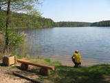 |
The aim of this territory is to regulate the natural and cultural landscapes of the upper reaches of the Daugava River valley, where there is a great deal of biological diversity. Nature trails have been installed in the park, as have bicycle routes. The river is good for boating in this area, too. The Curves of the Daugava nature park is part of the territory (see “Nature Parks”). |
|
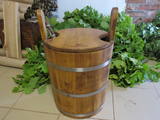 |
Here you will find everything that you need for a proper Latvian sauna – bowls, scoops, tubs large and small, switches, linen products and log saunas as such. You can tour the workshop, try out your own hand at the work that the owners do, and commission or purchase their products. |
|
 |
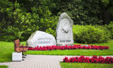
The Strūves Park is toward the northwest of Jēkabpils, on the left bank of the Daugava, and opposite the Ādamsona (Krustpils) island. The park was established in the 19th century as a place where the city’s residents could relax and hold celebrations. It can be said with absolute certainty that this is a place of global importance, because the park contains a memorial stone to Professor Friedrich Georg Wilhelm Struwe (1793-1864) from the University of Tartu. He was an astronomer and geodesist. The stone is at a place where Struwe completed his land survey of the Vidzeme Province of the Russian Empire. The meridian location which Struwe identified (and other points related to those locations are found in many other European countries) is on the UNESCO list of world heritage. |
|
 |
Neliela ziepju un dažādu citu ķermeņa kopšanas produktu darbnīca. Pašu audzētos un saimniecības pļavās ievāktos ārstniecības augus iestrādā ziepēs un skrubjos, gatavo no tiem izvilkumus augu eļļās, kurus iekļauj lūpu balzamos un krēmos. Ziepes tiek vārītas tā, kā to darīja agrāk - no sārma un taukvielām. Apmeklētājiem iespēja ielūkoties “Ezervanna” mazajā darbnīcā, paklausīties stāstā par ziepju vārīšanu, iemēģināt roku un radošumu skrubju gatavošanā vai “pamīcīties” ar ziepju veidojamo masu un pagatavot savu ziepju gabalu. |
|
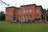 |
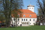
Muižas pils (no sarkaniem ķieģeļiem celta) ir meklējama ceļu krustojumā pie Gaujām – 2 km ziemeļaustrumos no Jaunpiebalgas centra, Gaujas labajā krastā. Līdz 1918. g. muižas īpašnieki bija slaveno grāfu Šeremetjevu dzimta. Muižas pili nodedzināja 1905. g. nemieros, bet vēlāk atjaunoja. Muižas pilī bijušas dažādas iestādes: slimnīca, kolhoza „Piebalga” administrācija, mūsdienās – pašvaldība un dažādu sadzīves pakalpojumu sniedzēji. |
|


