
| Нo | Название | Описание |
|---|---|---|
 |
Хозяйство и молочный завод Mätiku занимаются производством и переработкой молока, а также разводят кур-несушек и овец. На небольшом молочном заводе из молока собственных коров производят самые разнообразные молочные продукты. По предварительной договоренности можно посетить хозяйство, познакомиться с его работой и попробовать продукцию. |
|
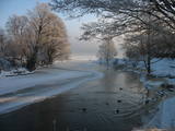 |
The Slocene River flows through Lake Valgums and Lake Mazezers before flowing into the western part of Lake Kaņieris. It is part of a branched and swampy delta in which there are seasonal restrictions aimed at protecting birds. The wetlands which are alongside the river are difficult to access in many places. Before the Starpiņupīte was dug between Lake Kaņieris and the Bay of Rīga (the water level is regulated with sluices), the water from the river flowed along what is now the Vecslocene River all the way to Sloka, where it ended at the Lielupe River. The Vecslocene can be used by canoe boats only when the water level is high and then from the Old Ķemeri road to the place where the river enters the Lielupe. Between Milzkalne and Lake Valgums, the river is not navigable because of many fallen trees. During the springtime, the estuary of the Starpiņupīte is a good place for bird watching. |
|
 |
Sēlijā, 5 km attālumā no Aknīstes, mājā "Skārdupītes" atrodas biedrība “Sēlijas laivas”. Kamēr teritorijā vēl tikai tiek attīstīta aktīvā tūrisma bāze, jau tagad viesiem tiek sniegts ieskats laivošanas kultūras attīstībā, kā arī ir iespējama dažādu laivu veidu noma un laivošanas tehnikas apmācība. Papildus: vides gida pakalpojumi ar iespēju laivojot iepazīt upes ekosistēmu, floru un faunu. |
|
 |
Autentiskā Zypliu muižas vidē izveidots restorāns. Kulinārais mantojums - Lietuvas muižniecības ēdieni. Ēdināšana, degustācija, izglītības programmas. |
|
 |
В 2014 г. при посредничестве Ботанического сада Шяуляйского университета был основан Музей генофонда балтийских растений. Посетителей ждет объект площадью 0,34 га, длиной 85 м и шириной 40 м. |
|
 |
Винодельня Allikukivi расположилась в старинном доме директора суконной фабрики. Гостей приглашают на просторный балкон поместья, где они могут продегустировать разнообразные напитки, узнать секреты приготовления вина, историю поместья и посмотреть, как растут ягоды. Производство фруктовых и ягодных вин по эстонским рецептам. |
|
 |
Недалеко от впадения речки Килминьупе находится овитое преданиями городище Троммеля – средневековое место укрепления. Оно находится в 100 м от хутора «Крауяс». Найденные здесь в 1977-м году во время археологических раскопок куски кирпича и черепки печных горшков свидетельствуют о том, что укрепление использовалось в Средневековье. Место связано с преданиями о пирате Троммеле, который здесь зарыл награбленное богатство, поэтому на дюне видно много ям, вырытых черными археологами. В предании говорится о пирате Троммеле, который со своими людьми грабил корабли в Рижском заливе от Курземского побережья до острова Роню. В древности на этом побережье стояли на якоре многие корабли, ожидавшие более благоприятного попутного ветра, чтобы обойти мыс Колка, но пират использовал его для своих корыстных целей. Он также собирал добро с погибших кораблей. Замок Троммеля был каменным. (Источник: Ройский ТИЦ) |
|
 |
One of the highest dunes in Latvia, located between Bernāti and Jūrmalciems villages. It is 37m high and offers a magnificent view of the sea and natural pine forests. The highest dunes in Latvia stand to the South of Jūrmalciems village: the Pūsēnu hill, the Ķupu hill, the Mietragkalns or Tiesas hill, the Pāļu hill, the Garais hill, the Ātrais hill, the Lāvas hill. The Pūsēnu dune is the highest of these dunes which are all called hills by the local people. The Pūsēnu hill developed between 1785 to 1835 when shifting sand became extremely dangerous. Several homesteads were buried in sand, among them „Pūsēni”, where a forester’s family lived. The family is said to have moved to Bārta. The dune was named after the buried homestead. Jēkabs Janševskis, a Latvian writer, wrote in his book „Nīca”: “In olden times, large pine trees were growing in the dunes on the coast of Nīca and they stood steady and firm. But i Swedish times (around 1650), the Swedes built a large kiln for charcoal and tar. Pine wood and stumps provided an excellent material for this. Once a big fire rose, and the charcoal kiln burned down as well as the whole pine forest. The remaining stumps and bare trunks in the vast burnout could not hold the storm-driven sand; it flew further and further burying not only the burned-out forest, but also the nearest fields. In wintertime, when the vast, low marshy grasslands were covered with ice, jets of sand drifted further over its surface, and soon most of the grasslands and large meadows turned into sandy heath-land and dunes.” To reconstruct Liepāja, severely damaged during WWII, a silicate brick factory was built in the town. The main raw material was white sand and it was taken from the Bernātu forest. In the 1960-ies they started to dig off the Green Dune and the White Dune, later also the Pūsēnu hill. The excavators used to work day and night, in three shifts. The work stopped at around 1980, as there was no more sand suitable for production of brick. A trail is set up to facilitate walking in the Pūsēnu Dune in the Bernātu Nature Park. |
|
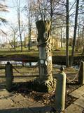 |
Памятник учредителям и директору
курорта "Кемери" (1861 г.) на берегу
Вершупите.
|
|
 |
Atrodas Valmieras Drāmas teātra ēkas rietumu spārnā. Piedāvā latviešu un pasaules virtuvi, svētdienās - brančus. Sadarbojas ar vietējām zemnieku saimniecībām. |
|
 |
Piemājas saimniecība "Rudā lapsa", kas atrodas Ludzas novadā, interesentiem piedāvā iespēju iepazīt laukus, apskatīt mājdzīvniekus, saklausīt dabu, ļauties mierīgai atpūtai. Tiek piedāvātas telšu un piknika/ugunskura vietas. Ciemos tiek gaidīts katrs, kas vēlas atpūsties un izrauties no ikdienas skrējiena. |
|
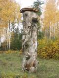 |
In 1951, when it died, the pine tree had a circumference of 4.63 metres. It was the thickest pine tree in the Baltic States
This is one of the few trees with such a long history for which age has been determined by counting up circles – 370 years. All that’s left is a conserved part of the stump at the side of the road. Cross-sections of the stump are on exhibit at the Latvian Museum of Nature and the Latvian Ethnographic Open-Air Museum.
|
|
 |
Pirts noma, izmitināšana, ēdināšana, banketu zāles noma, internets, makšķerēšana, volejbola laukums. |
|
 |
Расположено на обочине шоссе Рига – Лиепая (A9). Просторные помещения, выдержанный в дереве интерьер. Латышская кухня: Творог с селедкой и сметаной, крестьянский завтрак, суп из боровиков, жареная свинина с луком, тушенная печенка, домашние котлеты, жареные свиные ребрышки, картофельные блины и блинчики с начинкой. Особое блюдо: Горшочек с окороком «Юмис». |
|
 |
A cemetery has been found in this location since 1773, and among those who are buried there is the outstanding Latvian poet Ojārs Vācietis (1933-1983). A monument commemorating him is here, as is the Carnikava Estate repository that was built in the 18th century. The gravestone of a lessor of the estate, Falck, is also in the cemetery. |
|
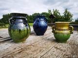 |
The craftsman produces pottery typical of Vidzeme, but with the range of colours that is typical of Latgale. These products fit in very nicely with the lovely landscape of Racupkalns. You can take a tour, watch the master at work, and work with clay yourself. You can also watch as he opens a Lettigalian ditch kiln. You can commission and purchase the products, as well. |
|
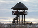 |
A island in the delta of Nemuna. Etnographical museum, Uostadvaris lighthouse, bird watching tower. |
|
 |
The saloon is on the shore of Lake Alūksne and the Jaunsētas country tourism and leisure centre. The log saloon’s interior is based on the style of the 17th century, when a girl was born in the area who was raised by her foster father Ernst Glick and would later become Empress Catharine the Great, Wife of Peter the Great of Russia. |
|
 |
Ap 1,6 km garā un labiekārtotā Adamovas dabas taka iepazīstina ar Adamovas krauju un tās apkaimē esošajām dabas vērtībām. Takas sākums meklējams pie autostāvlaukuma, no kura paveras plašs skats uz Krāslavu un Daugavas senieleju. Adamovas krauja (aizsargājams ģeoloģisks piemineklis) ir viena no garākajām (ap 1,7 km) un augstākajām (25 - 35 m) Daugavas kraujām. Tā veidojusies sānu erozijas rezultātā, Daugavas ūdeņiem noskalojot Daugavas pamatkrastu Adamovas loka ziemeļdaļā. |
|
 |
Located in the threshing barn of an old estate in Alsunga. There is a souvenir shop where you can purchase practical items such as shawls, gloves, stockings, dishes, herbal teas, etc. Creative workshops are available here for children, and if you contact the venue in advance, you can meet with Suiti women to learn about traditions and to sing and play games. The centre has been awarded the "Latvian heritage" cultural sign. |
|


