
| No | Name | Description |
|---|---|---|
 |
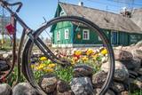
The organic farm Zemturi is a 30 min drive from Kuldiga. The farm is mainly engaged in breeding rabbits and is designed as a place for children to see, learn about rabbits, birds and other pets. The hosts have created two thematic trails, one for pets and poultry and the other for trees and flowers. Sauna lovers have access to the sauna, also fishing opportunities can be used. Overnight stays with family or a small group of friends are also offered. Excursions for big and small. |
|
 7 days
|
This tour features the best trails and attractions within the Gauja National Park. The walks are organised so that travellers are constantly on the move. The main “artery” of the park is the ancient Gauja River valley with many tributaries and deep ravines with massive sandstone cliffs from the Devonian period. The walk starts from one of the oldest churches in Latvia and follows the river which finishes at Sigulda bobsled track. Scenic views of the river, cliffs and nature trails await in the next section. The Amata river trail winds through untouched forest and inlcudes an icon of the Latvian landscape - Zvartes rock. At Cēsis explore the little streets, climb the tower of St John's Church and visit medieval castle ruins before heading to Cirulisi nature trail to explore the area's geological history. Ungurmuiza Manor is the only remaining wooden baroque manor house in the Baltics. A short trail weaves through ancient oak trees. The park also features several sites of cultural importance: Turaida Museum Reserve, Krimulda Manor and Ligatne historic centre. |
|
 |
Latvian blackhead sheep are in a clean environment at the Ances farm, which is in the Northern Vidzeme Biosphere Reserve near the border with Estonia. It is in the Naukšēni Parish, where chemical plant protection substances and mineral fertilisers have never been used intensively. The sheep roam freely during the winter and summer, with fencing to protect them against wolves and wild boar. The farm only uses female sheep born as twins or triplets, including animals for genetic resources. All of the sheep come from German blackhead sheep and are only mated with high-quality LT rams in January, February, August and September. |
|
 |
This is an ancient Liv village, known as Mustanumm is the last village in the south-easterly direction, and during the mid-20th century, just a few Livonians lived there. Of 307 inhabitants in 1935, only 15 were Livonians. At the beginning of the 19th century, there were six farms and a lagoon here, but at the end of the century there were 63 farms. The valley of the Baķupīte River and the sea had remnants of pilings that provided evidence about a Medieval port. Legends say that the sea robber Trommel had a castle on the left bank of the river during the 14th century. Sailing ships were once built in the region, as well. Two locations of cultural and historical importance in Melnsils are the ancient cult location that is the Baķi castle hill, and the castle hill of a sea pirate Trommel. |
|
 |
Karulas augstienes augstākais reljefa punkts (137 m.vjl.), kas virs tuvākās apkārtnes paceļas par ~ 60 m. Torņa kalnā ir uzbūvēts skatu tornis ar ļoti plašu apkārtskatu. Uz tā platformas ir novietoti panorāmas fotoattēli, kuros atzīmēti zīmīgākie plašākā apkaimē redzamie objekti – apdzīvotas vietas, pilskalni, baznīcu torņi u.c. Turpat izveidota atpūtas vieta un meklējams Rebases ainavu takas sākums. |
|
 |
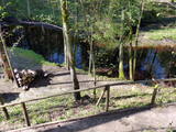
In the summer season we offer trips by raft and boats, camps for children, an area for organizing events, camping for the night. In the winter season "Baili" has a ski center - downhill ski tracks, ski and snowboard equipment rental, instructor services. Catering offer in a cafe. |
|
 |
Četrus kilometrus garā lokveida un marķētā dabas taka meklējama Plateļu pilsētiņas ziemeļaustrumu daļā. Tā ved pa dažādiem biotopiem – mežu, purvu, ezera malu, atklājot dažādas ainavas un tajās mītošās augu, putnu un dzīvnieku sugas. Šī ir interesantākā un ainaviskākā no Žemaitijas nacionālā parka takām. |
|
 |
Taka izveidota Limbažu Lielezera ZA galā, tā ir 3.6 km gara vienā virzienā. Ezeru ziemeļu galā izbūvēts putnu novērošanas tornis. Izbūvēts bērnu rotaļu laukums, labiekārtotas atpūtas vietas, izveidota laivu piestātne. Pāri Donaviņai izveidots gājēju tiltiņš uz pontoniem. |
|
 |
Das größte im Baltikum. Marathonloipe von Tartu, Wand der künstlichen Felsen und Trasse der Radmarathon. Skimuseum. Auf der Tehvandi-Sprungschanze ist ein Aussischtsplatform eingerichtet. |
|
 |
The Kassari Island is the fifth largest Estonian island, and it is found to the South of the Hiiumaa Island. There are two dams between the two islands, and a road for motor vehicles has been installed atop them.
|
|
 |
The Skala silence home is on the banks of the ancient Nevežio river valley. You will be served happy dishes from everything that is grown at the farm. |
|
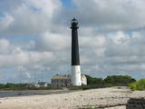 |
Die Südspitze der Insel Saaremaa – eine aus Geröll in der Irbenstraße langgestreckte Landzunge. Militärbefestigungen, Leuchtturm (1960), Vogelbeobachtungsort. |
|
 |
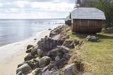
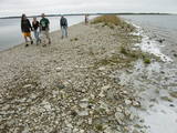
There are both sandy beaches with a good infrastructure and a rock beach in Roja. The rocky beach leads to a huge rock that is 2 m high and 12.5 m in diameter. The coastline is lovely with its scattered stones and its unhurried rhythm of time. At the place where the Silupīte River flows into the sea there are remnants of ancient wooden boats and iron nails. In 1939, Roja became the starting point for a closed zone, because the Soviet army and navy were sited there until 1993. The dunes at Krasta Street feature Soviet heritage, including a large cement wall from which border guards used to monitor the sea and catch those who violated the border. Behind the dunes was a base for border guards with everything they needed. Roja housed a Border Guard post and an air defence radio locator. (Source: Roja TIC) |
|
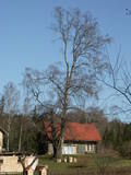 |
This is the thickest birch (Betula pendula) tree in Latvia and can be seen from the Klapkalnciems-Milzkalne road.
|
|
|
|
Atrodas uz Imulas upes un celtas 19. gs. sākumā. Uz dzirnavu vārtu staba redzama tēlnieces D. Ezergailes veidota pūce. Pūces dzirnavās savulaik uzņēma pazīstamo latviešu mākslas filmu Likteņdzirnas.
|
|
|
|
Observatory which was built (1808. – 1810. g.) Southeast of Doma Hill is called pearl of Estonian's science. There's a museum inside. |
|
 |
The Ķemeri water tower was built in 1929
and used to be a reservoir for drinking and
mineral water. Until World War II, there was a
viewing platform at a height of 42 metres from
which one could see the surroundings of
Ķemeri.
|
|
 |
The guest house is located in Varnja Old Believers village and on the Onion Route - a destination on the shores of Lake Peipsi, the largest lake in Estonia and the trans-border lake of the European Union. It is about 45 km from Tartu. It offers the oppurtunity to experience authentic accommodation in a real home of an Old Believer family. Everything from the furnishing up to spoons and forks is as authentic as possible. The house has three rooms that can accommodate up to 10 people. Additional services: smoke sauna, Finnish sauna, plastic sauna, sauna in a tent, outdoor hot tub, boat rental, bicycle rental, camping, lake safari on a Karakat (wintertime only), boat house accomodation. |
|
 |
Pie Gārsenes pils atrodas bijušais muižas parks 4ha platībā un pie tā sākas arī Gārsenes dabas takas. Dabas takas vēsturiski tika veidotas vienlaicīgi ar pils kompleksa būvniecību un ieeja takās atrodama pie mākslīgi veidotā, ar bruģa pamatni izliktā barona peldēšanās dīķa. Takas sākumā saglabājusies ošu aleja, ko savulaik stādījis barona dārznieks, savukārt taku vidusposmā apmeklētājiem ir iespēja pasēdēt uz Barona krēsla - akmens ar cilvēku veidotu sēdvietu tajā. Kopumā Gārsenes mežā vijas dažāda garuma labiekārtotas pastaigu un izziņas takas - Kultūrvēsturiskā taka, Zaļā taka, Baronu pastaigu taka, Staburaga taka, ar ierīkotām atpūtas un ugunskuru vietām. Takās apskatāmi vairāk kā 40 unikāli dabas objekti, gan dižakmeņi, gan dižkoki, kā arī un pagasta ievērojamākie arhitektūras un kultūrvēstures pieminekļi. No 2016.gada maija Dabas takās ietilpst arī „Krēslas stundas taka”, kas īpaši patiks zinātkāriem mazajiem ceļotājiem. Taka stāsta par Rūķu dzīvi mežā un tās veidošanas pamatā ir stāsti no „Lielās Rūķu enciklopēdijas”. |
|
 |
The museum is in the Lielvārde Park. It is in the granary of the Lielvārde Estate that was built in the early 19th century. It was later used as a residential building. A veranda was added to it in 1922. The museum has been there since 1970, and it features exhibits about the Latvian national epos “Lāčplēsis” and its author, Andrejs Pumpurs (1841-1902). The museum also features information about the history and ethnography of the Lielvārde Administrative District. Alongside it is a large rock that weighs around 80 tonnes and is known as Lāčplēsis’ Bed. A broken part of the rock is known as the Lāčplēsis blanket. Both rocks were once on the banks of the Daugava River next to the Lielvārde island. Waters from the Ķegums hydroelectric power plant now make waves in that area. Nearby is the so-called Spīdala log that was brought from Aizkraukle.
|
|


