
| No | Name | Description |
|---|---|---|
 |
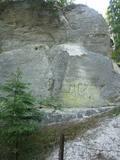
It lies between Pīlādžu street and the left bank of the river Siliņupe. In the 3rd to 2nd millenium B.C., there was a fishermen and hunters' settlement in the place of which there is installed an informational commemorational stone (Sculptor O.Skarainis). The settlement near the river Siliņupe is the oldest known human settlement in the area of the Ķemeri National Park. There are found many artifacts: pottery fragments and arrow tips, flint and amber pieces, etc..It is possible that the adjacent residential area has been the place of a cemetery. A small portion of the finds is displayed at the Lapmežciems Museum, the other ones are located in the National History Museum of Latvia. |
|
 |
Kaņieris is a seriously overgrown and
shallow seaside lake. Its water level was
adjusted several times during the 20th
century so as to obtain agricultural lands.
The lake has 14 islands, among which nine
are natural and the rest are artificial and
aimed at attracting nesting water birds.
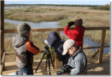
Lake Kaņieris has one of the richest
diversities of birds in Latvia. An
ornithological nature reserve was
established here in 1964. In 1989, the lake
was placed on the list of major birding
locations in Europe, and in 1995 it was put
on the list of the Ramsar Convention. At
the southeastern shore of the lake is a
boating facility (only rented boats are
permitted on the lake). A bird-watching
tower was erected on the Riekstu
peninsula in 2009
|
|
 |
The Dole is the largest island in the Daugava River, surrounded to the Northeast by the rapid waters of the Daugava and to the Southwest by calm and gradually overgrown waters from Dry Daugava. The island is a specially protected nature park, established in 1986 to protect the landscape and cultural and historical values of the island in the wake of the construction of the Rīga hydroelectric power plant, as well as rare and protected species of plants and animals. The island is also meant to provide education and leisure for visitors. Best known on the island is the Daugava Museum, which is in the mansion of the old Dole Estate. The museum features some 13,000 exhibits that speak to the history of the island and the river – Baltic and Livonian apparel, tools and household objects. The exhibition also presents the Daugava as an important waterway and the related history of forms of transport and rafters. In the park is an open-air exhibition with reconstructed lamprey eel traps and a barrier to fish salmon, along with a set of fishing tools. A dolomite cliff is alongside the museum on the steep shore of the Dry Daugava. The ruins of the Vecdole castle can be found on the south-eastern end of the island, near Bēči. |
|
 8 days
|
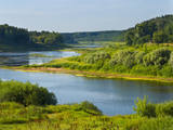
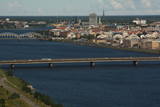
The Daugava River is known as our river of destiny, the Daugava of our hearts, or our beloved mommy. It is a large and full-blooded artery of water that has flowed through our land and our history. The Vikings were aware of the river during the 5th century AD. Krāslava is the site of an ancient castle hill, and the fearless sailors were well aware of it in that downriver from it, the ships could sail with raised sails. It is known in Viking sagas as Dynasaiforgarðr. Goods from the East sail down the river to Rīga, where it is reloaded into seafaring ships for delivery to Europe. That has been the case for many centuries. Many powers wanted to control and govern the process, as is seen in the large number of castle hills, castles and populated areas around the river’s banks. The majestic ruins of the Koknese Castle, Krustpils, the grassy and mighty castle hill at Aizkraukle, another one at Daugmale. The unique fortresses at Daugavgrīva and Daugavpils are like large keys that lock or unlock this mighty and ancient trade route. Under the water in the Daugava are the ruins of the ancient Ikšķile Castle that was built by St Maynard himself. It is seen as the first brick building in the Baltic States. Nearby is Death Island, where Latvian riflemen fought for the future of their country and their land, defending each square metre of land. The Daugava proved insurmountable for Bermont’s troops, and the riflemen defended Rīga successfully. The curves of Daugava are unique. The village of Slutišķi is particularly known because the Daugava there is just like it has been in the past. The high dolomite shorelines and canyons that once made the Daugava unique in all of Northern Europe have now been lost in the reservoirs of hydroelectric power plants, as has the eternally weeping cliff of Staburags, the Liepavotu stream and the Pērse waterfall. The age of national renaissance in Latvia importantly began with a battle against the construction of another power plant on the Daugava, which would have fully destroyed the beauty of the noble river. We managed to protect it, if only a small part of it, but we succeeded. We must not stop! |
|
 |
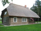
Sudrabkalni – a former pharmacy and medical treatment facility until the late
1980s, then an elementary school, and now a private residence.
|
|
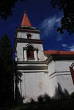 |
When you travel along the northern shore of Lake Sauka where the road to Klauce crosses your road, you will see the Sauka Lutheran Church among the trees. This is the third church at this location. It was opened in 1827 and can mostly be viewed from the outside. The altar is decorated with sculptures of St Peter and St Paul, as well as the altar painting “Jesus on the Cross with Mary and John,” which is by J. Doering. The organ was built by craftsmen in Jelgava, and the pipes were manufactured in Sauka. |
|
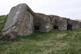 |
In addition to the Northern Forts, coastal batteries and Karosta district of Liepāja that are all mentioned in this database, there are other impressive elements of the former fortifications system – Lunete (the southern part of Lake Tosmare), the Central Fort (between Grīzupes Street and 14 November Boulevard), the Eastern Fort (to the South of Brīvības Street and the North of Lake Liepāja), the Southern Fort (at the Pērkone canal), and the Old Forts at the Olimpija stadium. All of these locations are freely accessible, but be careful if you go inside the former forts – they were blown up at one time and may remain dangerous.
|
|
 |
This is a stretched-out territory from Valmiera to the Ape Administrative District, and its primary “axis” is the unregulated Gauja River valley with a dense web of old rivers, park-like meadows of oak trees on their banks, and stands of oaks and other broadleaf trees. Many rare and protected birds, including corn-crakes, woodpeckers, wood grouses and others live and breed here. This is also one of the most important places in Latvia in terms of where the deciduous tree hermit beetle lives.
|
|
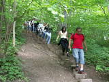 |
The Little Sigulda of Pilskalne is a place for longer or shorter hikes. Here you will find a number of trails – the Sprīdītis trail (1.6 km, featuring wooden sculptures of characters from fairy tales by Anna Brigadere), the Forest landscape educational trail (3.8 km), and the Highland landscape trail (8 km in each direction). The trails are in a sub-glacial depression with a number of little lakes and swamps that are connected by streams. This is a restricted environmental area aimed at protecting the landscape and its treasures. At the beginning of the trails (near Pilskalne) there is the Melnaiskalns (Rāmavas) castle hill, which is around 30 m high. |
|
 |
This 368 metre structure is the highest television tower in the European Union. Its viewing area, which is at a height of 97 metres, is the highest publicly available viewing area in Latvia. The location offers a fantastic view of Rīga and Old Rīga to Pārdaugava, the Bay of Rīga and Sigulda – a radius of at least 50 kilometres.
|
|
 |
The restaurant is on the eight floor of the steeple of the Church of the Holy Trinity in Jelgava, offering an outstanding view of the town’s most important cultural and historical monuments. The restaurant offers fine dining on the basis of French cuisine, as well as everyday and business meals. Latvian cuisine: Herring filet with cottage cheese, potatoes and onions. Special foods: Marija cake. |
|
 |
The Sietiņiezis cliff is on the right bank of the Gauja River between Valmiera and Jāņmuiža (follow signs along the road). There is a circular nature trail here. Sietiņiezis is one of the largest white sandstone cliffs in Latvia, up to 15 m high and around 500 metres long. There is an interesting diversity in form here, with small caves and niches, erosion-based ravines, as well as sandstone formations which are reminiscent of poles. The word "sietiņš" refers to "sieve," and the cliff is so called because bees have drilled holes into it for time eternal. From the southern part of Sietiņiezis, you can get a good look at the ancient Gauja River valley, and all around it are lovely pine forests. There is a place on the banks of the Gauja which is meant for campfires and meals. |
|
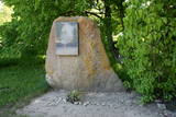 |
The memorial to Latvian President Gustavs Zemgals (1871-1939) was first installed in 1990 at the Brātiņi homestead, where he grew up. In 2016 it was moved to the Džukste memorial park. |
|
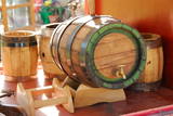 |
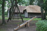
The craftsman manufactures barrels, hot tubs, furniture, stairs, doors and other useful objects. You can take a tour, learn about the relevant skills and experience, and help in manufacturing something that will be of use in the household. You can watch how barrels are made from start to finish, and also try your own hand at the craftsmanship. |
|
 |
“Airītes” is a museum found at the place where the first commander of the Latvian Armed Forces, Col Oskars Kalpaks and other Latvian soldiers (including three officers) fell during a battle on March 6, 1919. The public donated money in 1920 to build a monument, and it was unveiled on September 3, 1922. In 1935, work began on a building that was proposed by the Col Kalpaks Battalion organisation, the plan being to exhibit items related to Kalpaks’ battles. It was opened a year later. The monument was destroyed during the Soviet era, and the building housed a post office and some flats. The memorial was restored during the national Renaissance in 1988 and 1989, and on November 11, 1990, the museum was reopened. During renovations in 2007, the second floor burned down. The museum and exhibition were renewed in 2013. The exhibits speak to Kalpaks’ life during World War I and Latvia’s liberation battles. Employees regularly organise commemorative events in honour of Kalpaks, as well as celebrations of Lāčplēsis (Veterans’) Day. |
|
 |
This medieval saloon is a true Middle Ages saloon situated on the premises of the Ventspils Castle of the Livonian Order, next to which the river Venta flows. The saloon is thoughtfully incorporated in the castle ensemble, the interior design and the foods that are served create a true feeling of the Middle Ages. Latvian cuisine: Mutton soup, roast mutton, plaice filet, herring en papillote, homemade wines. |
|
 |
Seno un mūsdienīgo amatu prasmju popularizēšana, izkopšana un tālāknodošana. |
|
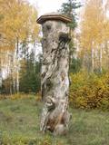 |
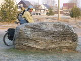
In 1951, when it died, the pine tree had a circumference of 4.63 metres. It was the thickest pine tree in the Baltic States
This is one of the few trees with such a long history for which age has been determined by counting up circles – 370 years. All that’s left is a conserved part of the stump at the side of the road. Cross-sections of the stump are on exhibit at the Latvian Museum of Nature and the Latvian Ethnographic Open-Air Museum.
|
|
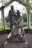 |
The monument is next to the Vecpiebalga Cultural Centre. Its architect was Ausma Skujiņa, and the sculptress was Maija Eņģele. |
|
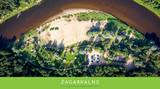 |
Not far from the "Žagarkalns" skiing slopes, at Cēsis, by the Gauja river. Tenting and caravan sites, boating camp. Large area, convenient for guest privacy. Cottages for parties, sauna. Boats and bicycles for rent. In winter - skiing slopes and services.
|
|


