
| No | Name | Description |
|---|---|---|
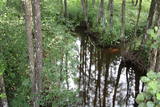 |
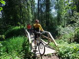
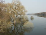
This territory is on both sides of the central section of the Raķupe River. On the banks of the river, there are many different meadow habitats, as well as massive oaks growing in the places of former farmsteads which are uninhabited by now. This is an important place for rare plants and animals. There is no tourism infrastructure for visitors in the area. Visitors who are especially interested in the environmental cognition are advised to visit the territory in attendance of experienced local guide. Raķupe is not usable for water tourism because of tilts of trees and beaver dams. |
|
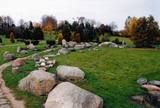 |
The terrain in this territory was created during the Ice Age. There are the ancient river valleys of the Minija, Salantas and Erla rivers, along with groups of rocks.
|
|
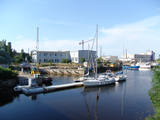 |
It is said that Krišjānis Valdemārs began to dream about a port at this location when he was a child, but a so-called protective port was only established in Roja in the early 20th century, with a protective dam 500 metres from the shore that was 213 m long. The dam gradually disappeared, and the port was shut down in 1933. Work on straightening the Roja River began in the 1930s, using a French machine to create berms and build rock dams and pile-based breakwaters that were subsequently extended several times. In 1932, fishermen built a 107 m breakwater. Reconstruction of the breakwaters was completed in 1972. The fishing kolkhoz Banga used to be active here, merging shoreline fishermen’s homesteads. (Source: Roja TIC) |
|
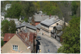 |
Valdemārpils is a small and quiet town along the shore of Lake Sasmaka. A village of craftsmen and merchants was established on the land of the Sasmaka Estate in the 17th century. There were quite a few Jewish merchants and craftsmen in towns in Kurzeme during the mid-19th century, and Sasmaka was known as their capital city. The city was named Valdemārpils in 1926. Its historical 19th century centre is a monument to urban construction. The town has a Lutheran church, an Orthodox church, a former synagogue, a monument to Krišjānis Valdemārs, and an outstanding linden tree. |
|
 |
Maršruts "Murjāņi - Līgatne" ved caur Gaujas senieleju ar devona smilšakmens atsegumiem, raksturīgo augu valsti un dzīvniekiem. Krastos sastopami Latvijā lielākie nogāžu un gravu meži ar liepām, ozoliem, gobām un ošiem. Upes līkumos palienē aug baltalkšņu un vīksnu audzes. Uz koku stumbriem atrodams plaušķērpis. Senieleja bagāta ar sausokņiem un kritalām, tāpēc Gaujas krastu mežos dzīvo visu Latvijā sastopamo dzeņu dzimtas sugu putni. Smilšainajās Gaujmalas pļavās un Gaujas vecupēs ir bagātīga bezmugurkaulnieku fauna. Upes krastos ir smilšakmens klintis ar čurkstu alām un zivju dzenīša ligzdām. Klinšu pakājē iztek avoti, kas uztur mikroklimatu ielejā. Gauja ir nozīmīga arī kā Latvijas lielākā lašupe. Maršruts ir daļēji marķēts un papildināts ar norādēm un informācijas stendiem. |
|
 |
Preiļu Siers is the largest cheese manufacturer in Latvia and exports 90% of its output. There are three “Preilis” stores in the town (Daugavpils Street 66A, Tirgus laukums 5, Rēzeknes iela 15) where are the widest range of Preiļu Siers products. Three kind of tastings of cheese "Čedars" produced in Preiļi, as well as "Čedars" cheese ice cream and a movie about the company are offered by local home producers "Pampūkas" beach terrace cafe, located in the active part of the city - beach area of Preiļi Park (pre-registration by phone 25867735, runs from the second Sunday of May till the second Sunday of September). In Preiļi , next to A/S "Preiļu siers" factory (Daugavpils iela 75) is one of few monuments to cheese in the world – the only one of its kind in Latvia. There are only four monuments for cheese in the world, two of them located in France, and one in each - Canada and USA. Therefore Preili can safely be called the cheese capital of Latvia. |
|
 |
Organic farming principles which maintain the biological diversity of the surrounding region will be explained to visitors during a tour which also offers consultations on environmentally friendly farming. Organic produce is available for purchase, and visitors can relax on the waterside - fishing, enjoying a sauna and making use of local accommodations. A herd of wild cattle can also be observed.
|
|
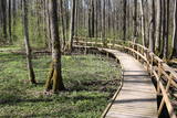 |
The excessively damp forests at this place include the Vēršupīte River bog, and this is one of the most diverse biotopes in Latvia in terms of the number of species that can be found here. The fact that the area is regularly flooded is shown by the fat roots of black alders – indeed, the place looks like a stand of mangroves. The wooden pathway that is the Dumbrāju trail starts at the Forest House for those who wish to examine the bog. The most impressive views are seen during spring floods or rainy seasons at other times of the year. The little river breaks out of its bed and floods a large territory. The Lake Sloka hiking trail is another place where you can study the Vēršupīte bog. The circular trail is 3 km long, and its beginning is at the Lake Sloka bird watching tower. |
|
 |
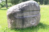
Latviešu dziedātāja un rakstnieka Marisa Vētras (īstais vārds – Morics Blumbergs) (1901. – 1965.) piemiņas akmens pie viņa dzimtajām mājām „Dārtiņām”. Norādes uz akmeni nav, tādēļ objektam var pabraukt arī garām. |
|
 |
A coast guard facility was located near the village of Užava during Soviet times. There is a lack of information about the use of the facility at this time.
|
|
 |
The granary of the Dviete Estate magazine is on the side of the Dviete-Bebrene road. The restored building dates back to 1874 and was used as a prayer house from World War I until 1929, when the Dviete Catholic Church was rebuilt. |
|
 |
The office of photographer Mārtiņš Buclers was recently found at the Sauka Unity House where the Sauka trade school was located. In 2010, the exhibition was moved to the Sauka Parish Council in Lone. Mārtiņš Buclers (1866-1944) was a founding father of photography in Latvia. He established the first company in the country which produced photo film and paper. The exhibits are of particular interest now that we are in the digital photo era. The Sauka Unity House is closed and can only be viewed from the outside, but alongside it is a memorial stone dedicated to Buclers, as well as a monument commemorating the 150th anniversary of photography. |
|
 3 days
|
This part of the Forest Trail gives an opportunity to see Setomaa or “the Land of Setos” which is inhabited by Setos – an ethnographic group with specific ancient traditions and a unique language dialect. Forest Trail hikers can visit the traditional Setos homestead and enjoy Setos cuisine. The forests of the region are especially charming in early autumn, when the ground is coloured lilac by the blooming heather. There is a good chance to pick wild mushrooms and berries. One of the most beautiful sections of this trail in Setomaa leads along the River Piusa, where the river is surrounded by sandstone outcrops. You will also visit the Piusa caves. The tour will end in Värska resort – with its sanatorium and SPA, which use the strengths of local nature: mineral water and lake mud. Värska mineral water is well known in Estonia and elsewhere. |
|
 |
The breeding of Californian red snails and production of bio-humus. You are offered a short excursion around the production, information about breeding snails and the production of bio-humus. |
|
 |
The Dviete ancient river valley is a unique territory of environmental, cultural and historical importance between Kaldabruņas, Bebrene and Dviete. The small Dviete River flows through the ancient river valley, through Lake Skuķi and Lake Dviete, and through the wetland meadows that are alongside the valley. During flooding season, these wetlands store up water from the Daugava River, rapidly absorbing masses of floodwater and then slowly returning the water to the river. The views during wet springs are incomparable to anything else that can be seen in Latvia. The specifics of the shifting water level in the ancient river valley are the reason why this is an important place for plants and birds during migration and nesting season. The Dviete Wetlands Nature Park has been set up to protect the territory. It is interesting that higher areas which do not disappear underwater during the floods are known as islands. Archaeologists who have studied the Dviete ancient river valley have found 15 possible settlements of the ancients (from the Stone Age, Bronze Age and Iron Age). They found a wealth of ancient objects of various kinds. There is reason to believe that this is one of the oldest and most important settlements in what is now southern Latvia. |
|
 |
A small settlement on the banks of the River Daugava, between Aizkraukle and Jaunjelgava. Skriveru region is associated with the life and work of popular Latvian author A. Upitis. Near Skriveri lies the oldest arboretum in Latvia. Its establishment in 1891 was started by the owner of Skriveru manor Maximilian von Siverss. In the park there are about 400 plant species, varieties and forms. One of the finest views of the Daugava will open from the so-called Krauklu Mountains – steep upper part of the right riverbank, which is an ancient hill fort. |
|
 |
Ap 7 km garā apļveida taka sākas pie leģendārajām Mangaļu mājām. Tā iepazīstina ar latviešu strēlnieku kauju vietām, vietām, kur atradušās to fortifikācijas, t.s. „Vācu valni” u.c. liecībām. Mangaļu mājās – Ziemassvētku kaujām veltīts muzejs. |
|
 2 days
|
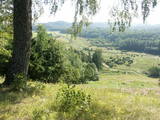
This tour will give you an impression of the eastern part of Latvia, which is less populated and also less popular among tourists. You will first arrive in Aluksne and explore the town, which is located at Alūksne highland, on the shore of Lake Alūksne. It is worth visiting Temple Hill – an old Latgalian castle mound and the place of the old town, Sun bridge, and the Castle manor park, Alūksne Lutheran Church and the Bible Museum. After staying there overnight you will go by bus to the start point of the hike in Ape. This Forest Trail section winds through a hilly farmland landscape, then enters a large dark forest, occasionally interrupted by the blue surfaces of lakes. After Peļļi, it crosses the Latvian/Estonian border and winds along the shores of the lakes Smilšājs, Sūneklis and Ilgājs for 2 km on the Estonian side, known as Paganamaa (translation: Devil's Land). There it descends and enters the Korneti-Peļļi subglacial depression, one of the most impressive ravines in Latvia. The Forest Trail returns to Latvia at Lake Ilgājs and, after a steep climb, takes you through a hilly area to the Drusku castle mound. Here you can enjoy a beautiful view. At the end of this tour, you will reach Korneti. The section is located in the protected landscape area “Veclaicene”. |
|
 |
This territory was established so as to preserve the natural and cultural landscape of the most distinct part of the Alūksne highlands – a landscape which is made up of the highest hillocks in the area – Dēliņkalns Hill, Dieva Hill, Saules Hill, the Drusku castle hill, and the Kornetu-Peļļu sub-glacial river bed (one of the most significant terrain differences in Latvia). There are lakes, too – Lake Pilskalns, Lake Dzērve, Lake Ieva, Lake Raipals, etc. There are also significant biotopes – hillside and gully forests, various kinds of swamps and meadows, damp forests, etc., all with their own species of flora and fauna. There are nature trails and tracks for cross-country and downhill skiing in the area. There are three restricted natural areas in the territory – Korneti-Peļļi, the Avotu forest, and Dēliņkalns Hill. |
|
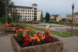 |
Madonas centrālais laukums, kas vēl 20. gs. sākumā bija tirgus laukums. Pēc apjomīgās restaurācijas tas ir kļuvis par ievērības cienīgu pilsētvides objektu. Laukuma ziemeļu pusē atrodas pilsētas un novada pašvaldība un Madonas novada TIC. |
|


