
| Нo | Название | Описание |
|---|---|---|
 |
Находится в восстановленном комплексе господской усадьбы «Смуку муйжас» (с XVI века). Летом можно трапезничать на террасе гостевого дома «Зиргу Сталлис», а в зимние месяцы – в баре у камина. Латышская кухня: «Полдник курземчан» (молочный суп с клецками и копченым салом), жареная на углях селедка, слойка из черного хлеба с взбитыми сливками, «Молочный колобок на деревенский лад» (парное молоко, сахар, корица, соус из садовых ягод), сырный картофель с жареной в меде свиной поджаркой. |
|
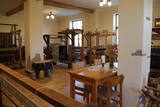 |
Мастерская находится в историческом здании Алсунгского музея, где вы cможете увидеть, как рождаются суйтские традиционные костюмы и их элементы, более подробно ознакомиться с ткацкими традициями Суйтского края и осмотреть богатое суйтский приданое. У каждого есть возможность самому поработать в мастерской под руководством опытных мастеров. |
|
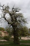 |
This is the thickest wild pear tree in Latvia. The tree is particularly beautiful when it is blossoming.
|
|
 |
Saimniecībā tiek audzēti Helix Aspersa Maxima sugas gliemeži. Ekoloģiska produkcija. Tie tiek baroti tikai ar vietējiem dārzeņiem un gliemežiem domāto īpašo barību. |
|
 |
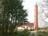
Старый Колкасрагский маяк – в конце Колкского мыса видны омываемые
волнами развалины построенного в 16 веке и многократно перестраиваемого
маяка, которые после очередного шторма и холодной зимы (льды!) становятся
все ниже. Когда-то развалины занимали солидный участок суши, теперь
понемногу уходят под воду.
|
|
 |
Находится на северном берегу второго по величине озера Латвии Разнас. Из окон кафе «Каштан» («Кастанис») приоткрывается один из красивейших видов на озера Латвии! Латышская кухня: Рыбный, щавелевый и холодный суп, ячменная каша, серый горох с салом, тушеные свиные ребрышки с капустой, рыбные блюда, домашние сыры и яблоки с медовой начинкой. Особое блюдо: Картофельная драченка - тертый и жареный картофель с мясом и луком. |
|
 |
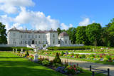
Atrodas Vecpiebalgas dienviddaļā pie Inešu ceļa. No sarkanajiem ķieģeļiem būvētā ēka uzcelta 1887. g. par vietējo iedzīvotāju saziedotajiem līdzekļiem. Vairāk nekā simts gadus šī ir vieta, kur vecpiebaldzēni pulcējas uz nozīmīgiem notikumiem, svētkiem, uzturot novada kultūras mantojumu. Celtni uzskata par vienu no spilgtākajiem Latvijas lauku arhitektūras pieminekļiem. Tai blakus uzstādīts piemineklis brāļiem Kaudzītēm. |
|
 |
This nature park is one of the richest and most unusual nature parks in Latvia in terms of its natural resources, the surrounding environment, the landscapes, the biological diversity of the area, and the cultural monuments which are found there. The main treasure there is the little-changed Daugava River valley, where there are eight major curves in the river at a length of four to eight kilometres. There are also the gullies of river tributaries. Outstanding views can be found on the steep shores of the Daugava River valley, particularly the Slutiški and Ververi cliffs and the Elerne gravel hill. There are some 20 archaeological monuments on the shores of the valley -- ancient castle hills at Najene, Markova, Vecračina, etc., countless churches -- the Juzefova, Sprukti, Borovka, Elerne, Sīķele, Kaplava and other churches, the Rozališki, Lielborne and other baronia estates, and the unique village of Slutiški, which is home to the Old Believers. There are interesting nature trails and bicycling trails in the area. Horseback riding is available, and there is a viewing tower along with other elements for tourists. Boating down the Daugava River is an interesting way to spend time. |
|
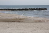 |
This is an enormously important territory for migrating birds. The most commonly spotted protected species of birds are the velvet scoter, the black scoter, the long-tailed duck, the little gull, the red-throated and black-throated loon, and the black guillemot. The territory is opposite the Dundaga and Ventspils administrative districts, and it covers 172,412 hectares.
|
|
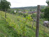 |
Already in the 10th century, an ancient village was located at the Sabile hill fort. After the division of Course land, Sabile was won by the Livonian Order, which built a stone castle (not preserved) here. Sabile is first time mentioned in written sources in 1253. During the 15th century an urban area started to develop at the castle. Town right was awarded to Sabile in 1917. Today Sabile is a small town, surrounded by many notable monuments. Roma culture is an integral part of Sabile and therefore, Sabile is also known as the Latvian capital city of Roma. Sabile has long been known for its wine-growing and oenological traditions, which have been reborn and enjoyable during the Sabile wine festival. |
|
 |
10 km garais pārgājienu maršruts iepazīstina ar vienu no vēl retajiem, cilvēka mazāk ietekmētajiem Daugavas senlejas posmiem. Tā sākums – Aizkraukle, finišs – Skrīveri. Gar upes krastu izvietotas atpūtas vietas. Maršrutu var braukt arī ar velosipēdu. |
|
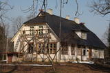 |
Several of the buildings of the Šlītere Semi-Estate have survived to the present day – the servants' house (late 19th century), the pump house (mid-19th century), the smokehouse (mid-19th century), the cattle barn, etc. A forestry building was built here in 1936 and renovated in 2010. Since the end of 2009, the administration of the Slītere National Park has been housed here. Today the building also houses the Kurzeme regional branch of the Environmental Protection Board. Opposite the building are two yews, and there is a productive ivy which has covered the northern side of the servants' house. The common yew and the Baltic ivy are symbols of Šlītere, and you can see and photograph them here without "bothering" them in their natural environment. The pump house contains a well that is unique in Latvia – it is 34 m deep, which is nearly the height of the Blue Hills of Šlītere. It reportedly was active until the 1970s and delivered water to the forestry system. A fragment of the stone well can be seen as a part of the wall of the pump house. The semi-estate is surrounded by small elements of a park, including an impressive alley of elm trees. Locals says that pre-war Latvian President Kārlis Ulmanis spent the night at the building once while on a hunt. |
|
 2 days
|
This route leads through the Curves of Daugava nature park, which is an area that was once to be flooded for the construction of the Daugavpils hydroelectric power plant. The central artery in the park is the ancient Daugava River valley, and the specific here is eight grand curves with a length of 4-6 km. The highest banks of the river are at the so-called Daugava gate, with the mighty Ververi and Slutiški cliffs. More than ½ of the territory is forested for hiking, nature watching, berry picking and mushroom hunting. The Daugava River valley has one of the greatest diversities of flora -- >800 different kinds in all. This is also a multinational environment with Lettigalian, Lithuanian, Polish, Russian and Belarusian traditions and heritage. The Slutiški village, which is unique in Latvia, is popular among tourists. Route information from Latvijas Lauku forums |
|
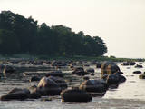 |
Back when the Baltic Sea was part of the ancient Littorina Sea, the coastline emerged as a small and shallow shore that was formed 4,500 to 5,000 years ago. The coastline has little rocks and gravel that have preserved typical examples of fauna from the Littorina Sea. The ancient cliff is best seen at the Dobeļi homestead in Kaltene. This is one of a few parts of the shore of the Bay of Rīga where there was an abrasion coastline during the era of the Littorina Sea. The shallow bay is popular among birds which feed and rest here during migrations. (Source: Roja TIC) |
|
|
|
Kaļķis is a populated area where
dolomite is still extracted from quarries in
the region (Kalnciems2 is one such
quarry). Some of the quarries are flooded.
|
|
 |
The Palanga Botanical Garden surrounds the Palanga Amber Museum and is one of Lithuania's most beautiful and well-kept parks. It is in the area of the St Birute Forest, and it is familiarly known as the Birute Park. The park covers 101.3 ha of land, and offers a wide variety of landscapes, carefully organised trails, flowerbeds, two ponds and small architectural elements. |
|
 |
This partly forested hillock stands 40 metres above the surrounding area and offers impressive views. The fact that this was once a castle hill is attested by the presence of a moat and remnants of defensive fortifications. It is thought that Lettigalian tribes settled here in the 10th century AD. You can climb the hillock to take a look at the surrounding landscapes. |
|
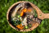 |
You can learn how to cook fish soup here, and the recipes are based on hundreds of years of fishermen's traditions in the Upper Aukštaitija region. You'll learn all about local dining traditions, local lifestyles and traditions since the 13th century. You can go fishing, as well as mushroom and berry picking. |
|
 |
Temple Hill is steep (with artificially created steepness) and about 30 m high, and it is opposite Marijas Island. It is an ancient Lettigalian castle hill, 80 m long and 40 m wide, with several artificial ramparts. One of the oldest objects found in the region is an axe from the 2nd to 3rd millennium BC. Archaeologists believe that the island was populated at that time. There was a Lettigalian castle on the hill during the 10th and 11th century, but it was sacked by the Holy Crusade. The surface of the castle hill was transformed comparatively recently in 1807, when a granite rotunda was built there in honour of Russian Field Marshall Sheremetev and Swedish captain Wulff. The view of Lake Alūksne and the town is one of the most beautiful ones in all Vidzeme. The Sun Bridge (1937) is also worth a look. A wooden viewing platform is nearby. |
|
 |
Akmensrags is important for birds while they are migrating, spending the winter, and molting in the summer. Most often we find the little gull and the red-throated and black-throated loon. The territory is opposite the Pāvilosta Administrative District and covers 25,878 hectares.
|
|


