
| No | Name | Description |
|---|---|---|
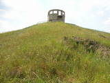 |
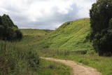
This unique territory covers more than 24,400 hectares, and the Soviet military used it as an aviation training centre. The history of the base dates back to 1951, when four kolkhozes were shut down, roads were closed, and several hundred farms and homes were simply moved elsewhere. A civilian presence at the base was restored only in 1993, when several new roads were installed. If you want to get a bird’s eye view of the base and its forests, you have to climb a high, manmade hillock from which commanders watched manoeuvres. We do not recommend that you wander off from the roads!
|
|
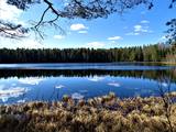 |
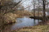
Ķekavas novadā, Daugmales pagastā atrodas jauka atpūtas vieta - Lejas ezers. Ezeram var apiet apkārt, taka nav marķēta un iešana ir pa mazām meža taciņām. Slapjākā laikā taciņas vietām var būt mitras un dubļainas. Pastaiga aizņems aptuveni stundu. Pie ezera ir iekārtotas vairākas piknika vietas. |
|
|
|
Atrodas pie Jēkabpils – Rēzeknes autoceļa (A 12), - autostāvlaukuma malā. No torņa redzama samērā plaša Teiču purva daļa ar atsevišķām salām (kokiem apauguši paaugstinājumi) augstā purva ainavā. Teiču purvam ir dabas rezervāta statuss, tādēļ apmeklējams ir tikai tornis. |
|
 |
The Karosta prison cannot be described, it must be experienced and survived. That’s an opportunity for everyone. This is the best example in Latvia as to how the military heritage can be used for tourism purposes. Others can learn from this site. |
|
 |
The farm offers various goodies, including cheese, butter, cream, cottage cheese and fresh eggs. |
|
 |
Größe Steinkreisen. In der Mitte befindet sich eine oder mehrere „Steinkapseln” für einen Verstorbenen. Wurden im Eisen- und Bronzealter errichtet. |
|
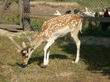 |
The owner will give you a tour during which you will see African ostriches, fallow dear, the Soay breed of sheep, exotic birds and fowl. You can establish contacts with the animals and purchase souvenirs. |
|
 |
The craftswomen produce clay dishes, vases, candlesticks, chandeliers, garden ceramics and small objects. Clay dishes with wooden handles are interesting. The women will offer you a tour of their workshop, a chance to see them at work or to try out your own skills at the potter’s wheel, as well as to purchase objects which have already been manufactured. |
|
 |
Žagare has long since been known for a special type of cherries. There are various varieties which only differ in terms of when they are ripe and productive. There are different types of trees. The cherries grow at nearly home, and that is an exclusive symbol of Žagare. |
|
 |
This is one of the few places in the world where lamprey eels are caught at the industrial level and with a fishing method that has been used for the past 150 years – a weir that stretches across the river and has creels along it. There are three weirs in all on the Salaca River. A local fisherman will teach you about the process and allow you to taste and purchase roast lampreys. |
|
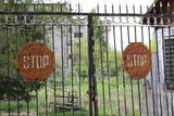 |
The first Dnyestr-M radar station was opened here in 1969 to calculate the trajectories of ballistic missiles. The trajectories of satellites were also calculated here. The range of the radar station was 5,000 km. In 1972, construction began on a second, more modern radar, the Dnyepr-M. In 1977, it was ready for use, and the first radar was modernised at the same time. The two radars were located in buildings that were 250 m long and 17 m high. During a 24/hour period, they could identify the height, speed and flight trajectory of up to 750 space objects. In 1985, work began on a third, even more modern radar – the Daryal-YM. This was a radar that could “peek” across the horizon. The antenna building was 117 m high (19 stories), 80 m long and 80 m wide. It had a planned range of 6,000 km, but it was not completed. After the withdrawal of the Russian army in 1995, the building was blown up. That cost LVL 6,172,311 and used up 360 kg of explosives. The territory of the radar stations took up 1,072 hectares, with barracks, a hotel, 551 apartments, a medical facility, a water tower, a war hospital, a bomb shelter, etc. The aim of the facility was to monitor space above Western Europe and North America, as well as to “intercept” any ballistic missiles that were fired at the USSR. The territory is closed to visitors, but it is an important part of Latvia’s military heritage. The abandoned territory can be viewed from the outside. The nearby bus stop is called “Kombināts.” This was the only facility of its kind in the Baltic States. !!! Since March 2018 the Skrunda army base is closed for visitors. |
|
 |
Located at the Lake Burtnieks southern shore, these are wetland meadows which are regularly flooded and which are important places for various birds, including the corn - crake, to nest. This is part on the environmentallyrestricted area which covers the meadows of Lake Burtnieks. |
|
 |
From the Markova castle hill, which you will access from the local information trial, you will see a view of the Daugavsargi curve of the Daugava. Further along, you will reach the open shore of the Daugava to see one of the most unique landscapes of Latvia’s river valleys. The Slutišķi village of Old Believers and the mighty Slutišķi cliff will be in the background.
|
|
 |
The former Ķemeri swimming facility used
to have a building of wooden bathtubs in the
19th century. The mud treatment facility which
is designed in the style of Classicism was
erected in 1924. The Ķemeri clinic was opened
here after World War II. A monument to Ivan
Pavlov, a distinguished Russian doctor and
physiologist is on the western end of the ruins,
and no one has taken much care of it, either.
|
|
 |
Kafejnīca "Kalnakrogs" atrodas Skrundas novada Rudbāržu pagastā pie Rīgas - Liepājas šosejas. Kafejnīcas ēdienkartē iekļauti latviskie ēdieni, iespējams pasūtīt banketu un izīrēt telpas semināriem. Piedāvā nakšņošanu. |
|
 |
Found on the right bank of the Daugava, approximately half a kilometre upriver from the Skrīveri Agricultural Institute, the hill is in a place where the bank of the Daugava River Valley is split by the deep Ašķere stream valley. The castle hill was occupied beginning in the first millennium BC, with antiquities from the Lettigalian and Livonian tribes found there. During the 13th century, a brick castle was built on the hill, but it was sacked during the 17th century. Nothing remains of the castle. The castle hill is also known as Raven Hills, and it offers one of the most beautiful views of the central part of the Daugava. In the direction of Rīga, there is a field with a white cross that represents an ancient church. There is a hiking trail along the Ašķere stream. The area is well improved with four trails. The longest is the Daugava trail (10 km). |
|
 |
In the small town of Pļaviņas, at the place where the Skanstupīte River flows into the Daugava (Friendship Park), there are the remnants of a set of small and low fortifications known as the Swedish bastions. This was a place of military and political importance, because here was the place where the boundaries of Vidzeme (under Swedish rule), Latgale (under Polish rule), and the Duchy of Kurzeme (on the opposite side of the river) all came together. In 1625, the Swedes were defeated by the Poles here, and Swedish King Gustav Adolf almost lost his life. Medieval bastions of this kind can be seen in some other places of Latvia, as well.
|
|
 |
Lipuški Old-Believers Prayer House was built in 1893 at lake
Rāzna in village Lipuški. In former days, it was one of the largest Old-
Believers parishes in the Baltic countries; you will notice Old-Believers cemeteries that are placed in the
neighbourhood.
|
|
 |
The “Nida-Pērkone” protected marine territory is one of the most biologically diverse marine territories along the shore of the open part of the Baltic Sea, and it is enormously important for environmental protection. The most important reef territories are found here. During migration season, most species of migrating birds that are found in Latvia cross the area. The territory is particularly important to protect the goosander and the little gull. The territory is opposite the Rucava and Nīca administrative districts and covers 36,703 hectares. It overlaps the marine section of the Pape Nature Park and the Bernāti Nature Park.
|
|
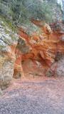 |
Sarkanās klintis savu vārdu ieguvušas pateicoties sarkanajiem iežiem. Tieši sarkanā ir mīlestības krāsa, tāpēc sarkanās klintis ir romatiska pastaigas vieta mīlniekiem. Smilšakmens klintīs redzamas plaisas, kas sašķeļ sarkanīgos iežus, radot neparastu dabas mākslas darbu. To virsma ir diezgan izrobota, kas veido klintīs nelielas alas un nišas. Sarkanajās klintīs ir arī daudz dažādu avotiņu. Pazīstamākais no tiem ir Rūcamavots. Tam ir šāds nosaukums, jo tas, nākot ārā no zemes, izdod nelielu rūkoņu. |
|


