
| No | Name | Description |
|---|---|---|
|
|
Atrodas Zebrus ezera austrumu krastā pie Latvijas Valsts mežu laivu bāzes. No torņa labi pārskatāms Zebrus ezers, ziemeļu virzienā – Ezerlūķu pilskalns. Laivu bāzē – atpūtas vietas. |
|
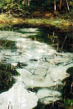 |
Three little lakes can be found on the left bank of the Pirita River with many erupting “eyes” of streams, each with its own colour (bluish-green, white, dark). This puts together various colour combinations. These are often known as the most beautiful streams in Estonia. Some pump out as much as 20-30 litres of water per hour. It is said that the waters are good medical resources, particularly for the eyes. There are improvements in the area of tourists.
|
|
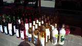 |
The owner of the venue makes homemade wine on the basis of traditions that have been handed down from generation to generation. You can taste four different wines along with snacks and engage in philosophical discussions about winemaking recipes. You can also buy the wines. |
|
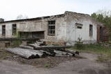 |
The zenith missile base at Rucava is in the forests of the Baltic coastline. The facility is owned by the regional local government and is not used at this time.
|
|
 |
Beķereja, veikals un kafejnīca atrodas Vaiņodes centrā. Saimniece cep pīrāgus, cepumus un plātsmaizes Latgales meistara mūrētā maizes krāsnī, gatavo tradicionāli latviskus ēdienus, klāj svētku galdus. Beķerejas veikalā var iegādāties ceptuves gardumus un uzzināt par apkaimes interesantākajām vietām. Par dienas aktuālo piedāvājumu beķerejas saimniece ziņo facebook.com/ineta.zveja . |
|
 |
This is the only dairy processing company in Latvia to prepare “Tea” cheese from fresh milk and with various flavours. The company offers smoked cheese sausage, cheese salad, and the “Gardumiņš” grand of sweet cottage cheese treats, as well as other types of dairy products. These can be bought at the Daugavpils market, the Central Market in Rīga, and all Latgales Dairy retail locations in Latvia. |
|
 10 days
|
During this trip you will visit the workshops of craftspeople, farms that breed horses, as well as various destinations where you can enjoy country goodies. Ancient skills are now a modern application. First you will stop in Ikšķile, and at the very beginning of the trip, you will visit a cellar that stores birch juice wine and taste sparkling wine. In Skrīveri, you will be surprised by the transformation of milk. A cosy café on the main street of the small town offers outstanding homemade ice cream featuring strawberry, anchovy and horseradish flavours. In Koknese, you can supplement your wardrobe with a new leather belt, bag or stylish leather jewellery. A farm that grows hemp will offer a small tour, as well as hemp delicacies. The work of black ceramics masters in Latgale fits into modern interiors. The Aglona Bread Museum offers a chance for visitors to bake their own loaf of bread. The visit to the next farm will allow you to add tasty cheese that has been made from milk from Latvian brown cows. The last stop in Latvia will be Daugavpils, which features an art centre featuring the work of the globally known abstractionist Mark Rothko, as well as the Daugavpils fortress, that was built in the 19th century and is an impressive military building. This is one of the most popular tourist destinations. From there you will travel to Lithuania, where you will visit several traditional farms. The Ilzenbergo Dvaras estate has a bio-dynamic farm. You will taste Lithuania's national sweets which are called šakotis. You will visit the town of Anykščiai, which offers a hike along a trail that is above the trees. A horse museum offers a look at old farm equipment. Next you will visit farms that will inform you about traditional Lithuanian cuisine and the work of potters. The Dubingiu horse farm offers horseback rides. At the conclusion of the tour you will visit the unique Trakai lake castle (14th and 15th century), as well as Vilnius. |
|
 |
Liepene, in the Ventspils District, was once home to a coast guard division. The facilities are now privately owned and offer accommodations to tourists.
|
|
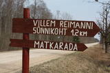 |
Kultūrvēsturiska taka (garums ~ 2 km) Tipu (Tipu) ciemā, kas iepazīstina ar vairākiem interesantiem objektiem: veco skolu (1931. g.), Hallistes upi, pirti un Paunas saimniecību, kurā dzimis viens no Igaunijas nacionālās kustības līderiem Villems Reimans (1861. – 1917.). |
|
|
|
Pie Melekiem sākas dabas lieguma teritorija. Meleku
krastmala būtiski mainījās 2005. g. orkāna laikā.
|
|
 |
This is a miniature zoo next to a tributary of the Ogre River, and most of it is taken up by a paddock of rabbits. Children just love the animals, as well as the hutches that were designed on the basis of the architecture of estates and castles. There are also goats, pigs, geese, peacocks, mandarin ducks and pearl hens. Children can help in feeding the animals. |
|
 |
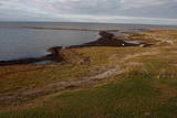
Happiness House (Laimes maja) is a recreation place situated in a very beautiful place on the seashore – on Cape Kolka. Here you will have a chance to relax, watch sunrises and sunsets, enjoy the sea, quiteness and peace. |
|
 |
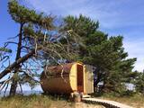
Puises ragā (Puise nina) ir uzcelts divstāvīgs atpūtas nams, kas apvienots ar putnu vērošanas torni. No tā paveras skats uz piekrasti, kas ir iecienīta migrējošo zosu atpūtas vieta. Šī ir privāta teritorija, kuras apskati vēlams saskaņot ar īpašnieku. |
|
 |
This is a part of Latvia in which various manifestations related to layers of earth made up of water-soluble lime can be found. The most unusual elements here are Lake Vecezers and Lake Linezers. The water of the latter lake has flowed underground several times over the last few decades, with the remaining lake hole as much as nine metres deep. No one can fully explain how this happens. A tourist trail encircles Lake Linezers.
|
|
 15 days
|
The road trip from Vilnius to Rīga will take you to the most beautiful and important sightseeing places of the Next on the route is the Dubysa Regional Park, which includes the spectacular Dubysa river valley, historic churches and mounds along its banks. Be prepared, since the terrain of this area is rather rolling. Next, you will visit the town of Šiluva, which is a Catholic pilgrimage site, and then travel to the Tytuvėnai Regional Park, where you walk the natural trail of the lake of Gilius, which is part of the Forest Trail. The tour will continue in the Kurtuvėnai Regional Park, where you will walk one section of the Forest Trail from Kurtuvėnai to Šaukėnai, leading along small forest trails, educational trails, beautiful tree alleys and through wetlands. Then you will go to the region of Samogitia, visiting Telšiai and walk one of the Forest Trail sections along Lake Plateliai. Next, the tour takes you through the stone town of Mosėdis to Latvia, where you will stop over to have a walk on one of the oldest towns in Latvia – Aizpute, enjoying its 19th century wooden architecture and the local wine brewery. Next you will take a small walk along the Forest Trail in the eye-catching Kazdanga manor park and drive on to the most beautiful town of Kurzeme – Kuldīga. At the end of the tour, you will walk a section of the Forest Trail along the Abava River Valley Nature Park and nature trails in the Ķemeri National Park. |
|
 |
This farm offers education about animals who live there, how they are bred and what the origins of their breeds are. You can gather eggs, learn to sit on a saddle and ride horses. The farm has Aberdeen Angus cattle, alpacas, various birds, horses, ponies, rabbits and goats. |
|
 2 days
|
Маршрут подходит для активных туристов, интересующихся многообразием природной и культурной среды национального парка «Кемери». Национальный парк «Кемери» (основан в 1997 г.) создан, прежде всего, для защиты водноболотных угодий – мелководного побережья Рижского залива, заросших прибрежных озер, болот, влажных лесов (трясин и др.) и пойменных лугов, как значимых мест произростания многих растений (~ 25 % от видов растений, занесенных в Красную книгу Латвии) и обитания животных, особенно мест скопления гнездящихся и перелетных птиц. На территории парка находится один из крупнейших заболоченных массивов Латвии – Большое Кемерское болото. Заболоченные массивы являются значимым местом образования и выхода сероводородных вод, а также местонахождения лечебных грязей, используемых в медицине, которые в свое время послужили основанием для создания известного курорта «Кемери». Информация о маршруте от Latvijas Lauku forums |
|
|
|
Veisieji reģionālais parks (Veisiejų regioninis parkas) veidots (1992.g.) Sudavas augstienes (Sūduvos aukštuma) ainavu, bioloģiskās daudzveidības un kultūras pieminekļu aizsardzībai. Viena no parka bagātībām ir ezeri, kuru iegarenās formas liecina par ledāja darbības rezultātu. Pēdējā apledojuma laikā šeit atradusies ledāja mala. Ezerus (kopā – 37) ieskauj lielāki meža masīvi uz kontinentālām (iekšzemes) kāpām, kas piemēroti atpūtai dabā, dabas vērošanai, ogošanai un sēņošanai. Parkā ir iekārtotas peldvietas, kur patīkami gremdēties vasaras tveicē, izveidotas dabas takas, bet mazās upītes, kas savieno ezerus, ir piemērotas braucieniem ar kanoe laivām. Veisieji reģionālā parka teritorijā ir liela augu un dzīvnieku daudzveidība. Šeit tiek aizsargātas arī tādas retas sugas kā Eiropas kokuvarde Hyla arborea (parka simbols), purva bruņurupucis Emys orbicularis, dažādas orhideju sugas u.c. |
|
 |
Café Ugandi is a cosy place in the very heart of Otepää, filled with a warm atmosphere, pleasant feelings, pure and delicious flavours. As soon as you arrive, you will feel the aroma of premium quality coffee and sweet pastries. The large showcase is filled with delicious cakes - you can enjoy them here or take them with you to enjoy later at home. |
|
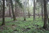 |
One of the rare places (see also Rucavas ivju audze) in Latvia where two rare and protected wild tree species grow - yew-tree and Baltic ivy. Territory is not marked on site with information signs or stands therefore it is hard for visitors to find. Not usable as tourism object.
|
|


