
| No | Name | Description |
|---|---|---|
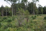 |
One of few places in Latvia (around 1 km to the North from Lapmezciems) where used to be beautiful juniper meadows. Since no agriculture activity (grass cutting, cattle grazing) has been implemented in the area, juniper meadows are overgrowing and disappearing. To save the area sustainable management is needed. Slitere National Park with Blue Mountain cliff and Slitere lighthouse is located in short distance from Kadiku nora (Juniper meadow).
|
|
 |
Small sandstone outcrops on the shores of the Ciecere River. Fish fossils have been found here.
|
|
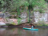 |
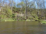
The Brasla River flows through a lovely valley that is approximately 300 m wide and up to 30 m deep. It is near the Inčukalns-Valka highway. The river has among the most beautiful rapids in the country, with mighty cliffs (the Brasla cliffs) that can be seen at nearly every curve in the river (except along the lowest reaches of the river). During the winter, various unusual frozen waterfalls can be seen in some of the cliffs, including the Krauļukalns cliff and the Jāņavārti cliff. On the left bank of the Brasla, opposite the Brasla fish farm, there are the Aņīte cliffs -- a series of sandstone cliffs that are 1 km long. The cliffs are between 2 and 35 m in height, and the sandstone cliffs are separated by ravines. On the right bank of the Brasla, there are major cliffs such as the Vāršavu cliff, the Kraukļukalns cliff, the Jāņavārti cliff, the Slūnu cliff, the Virtaka cliff and the Buļi cliff. How can you best learn about them? Boat down the river from the aforementioned highway or even from Straupe, which is further upstream. An alternative is hiking down the right bank of the river, though please take into account that the terrain is fairly extreme, and you are going to have to think about what to do when you arrive at the place where the Brasla River flows into the Gauja. |
|
 |
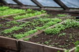
The hosts produce mixtures of dried herbs and vitamin tea in a full cycle - from seeds to a packet of spices. The farm beds and greenhouses grow a wide range of vegetables and herbs - dill, onions, garlic, chives, mint, sage, thyme, coriander, hyssop, tarragon, peppermint, chili, basil. Also used wild plants - nettle, gooseberry, viburnum, dandelion, yarrow, oregano. |
|
 |
Lustužkalns Hill (72 m ASL). A hunting
castle owned by Livonian Order master
Walther von Plettenberg was located here
in the 16 century. During the reign of
Russian Empress Catherine the Great, a
recreational castle was built here. A
legend from the time says that a golden
carriage is at the bottom of the local Lake
Valgums.
|
|
 |
The Kauguri canal dug in 19321933
to divert the waters of the Džukste and
Slampe rivers to the Lielupe River to avoid
broader emergence of swamps.
|
|
 |
This beautiful garden of practical ideas offers colourful flowers and a wide collection of coniferous trees which visitors can visit all year long. Behind the house are a vegetable garden and a group of greenhouses. |
|
 |
Atpūtas vieta Gaujas upes kreisajā krastā, pusceļā starp Virešiem un Aņņu tiltu (Gaujiena-Valka; P23). Pieejams galds maltītēm, ugunskura vieta, sausa malka, telšu vietas, tualete. |
|
 |
The Strūves Park is toward the northwest of Jēkabpils, on the left bank of the Daugava, and opposite the Ādamsona (Krustpils) island. The park was established in the 19th century as a place where the city’s residents could relax and hold celebrations. It can be said with absolute certainty that this is a place of global importance, because the park contains a memorial stone to Professor Friedrich Georg Wilhelm Struwe (1793-1864) from the University of Tartu. He was an astronomer and geodesist. The stone is at a place where Struwe completed his land survey of the Vidzeme Province of the Russian Empire. The meridian location which Struwe identified (and other points related to those locations are found in many other European countries) is on the UNESCO list of world heritage. |
|
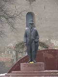 |
Opposite the tower of the Church of the Holy Trinity, the monument was designed by Arta Dumpe and commemorates Latvia’s first president, Jānis Čakste (1859-1927). It was consecrated on November 14, 2003, precisely 81 years after the statesman was elected to the important position. |
|
 |
At the estuary of the Inčupe River, there is the White Dune, which is around 18 metres high and is the most lovely element of the Vidzeme shoreline among those that have been created by the wind, sand and sea. There is a wooden footpath (the Saulriets trail) which is meant to view, but also protect the dune. It has a viewing area, too. The territory to the south of the river is in the Piejūra Nature Park.
|
|
 |
Atrodas Taurenē, Gaujas labajā krastā. Muižas apbūve, kurā ietilpst pils (19. gs. 80. gadi, arhitekts – R. G. Šmēlings, historisma un neoklasicisma stils), senie alus pagrabi, klēts, vecā pils un parks, veidojies 19. - 20. gs. Šobrīd muižas pilī atrodas Taurenes pagasta pārvalde un kultūras nams. Muižas kompleksā ietilpst ēka, kurā atrodas Vecpiebalgas novada tūrisma informācijas punkts un Taurenes novadpētniecības ekspozīcija (senajā ledus pagrabā). Parkā (ziemeļos no pils) uzmeklējams piemiņas akmens, kas veltīts komunistiskā terora upuriem. Pie Nēķena muižas sākās 0,4 km garā Cieres dabas taka, kas iepazīstina ar Gaujas krastu mitrājiem. |
|
 16 days
|
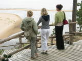
This grand hiking tour is provided for experienced hikers wishing to walk along a large part of the coasts of Latvia and Estonia, gain a detailed impression about the diverse coastal landscape, nature, birds and animals of the Baltic Sea. The Baltic Coastal Hiking Route sometimes runs through sandy beaches, sometimes along sections of beach covered in stones and pebbles. Sometimes the trail goes through coastal forests or stops at a fishermen’s village. There are many floodplain meadows, lagoons and shallow bays on the Estonian side, so sometimes the path goes along coastal trails and roads. In the end section of the route you will feel Estonia’s Nordic nature more. Part of the route runs along a sparsely populated seashore where you can be alone with yourself, but you will also be able to visit the most prominent cities. You will visit both capitals: Rīga and Tallinn. Enjoy the hospitality of the resort towns of Jūrmala, Pärnu and Haapsalu. During the hike, you will also get acquainted with the regions of small ethnic cultures: the Livonians in Latvia and the inhabitants of Kihnu in Estonia. |
|
 |
1275 is considered as a year of foundation of Daugavpils. This is the time when the Master of Livonian Order Ernst von Ratceburgs built Dinaburg castle at the Naujene hill fort. It suffered several Lithuanian and Russian invasion until in 1577 the castle was destroyed by Russian troops under the command of Ivan the Terrible. After this event Dinaburg was restored 17 km further on the right bank of the river, where now the town of Daugavpils is located. From 1810-1833a new fortress was built. In 1826 started the building of what is now the historic centre of the town. During the World War I the major industrial companies with workers were evacuated to Russia. During first Latvian Republic, the cultural life in Daugavpils flourished. Most part of the town was destroyed during World War II – in the July of 1944. Nowadays the town is the second largest town in Latvia and is an important economical centre of Latgale historic region. Restoration of Daugavpils Fortress was launched recently; this project can be considered as a unique on the European scale. |
|
 |
Atrodas Vārtājas ielejas labajā krastā un labi saskatāms no Priekules – Grobiņas (P106) ceļa. Senās kuršu zemes – Piemares pilskalns, kas vēstures avotos pirmo reizi minēts 1253. gadā – līgumā starp Kurzemes bīskapu un Livonijas ordeni. Viens no lielākajiem Dienvidkurzemes pilskalniem. Iespējams, ka iepriekš – arī sens kulta kalns. Pagājušā gadsimta sešdesmitajos gados veiktajos arheoloģiskajos izrakumos konstatēts, ka pilskalns bijis apdzīvots jau vidējā dzelzs laikmetā. Pie tā konstatēta liela senspilsētas vieta. |
|
 |
The farm grows some 25 types of plants and prepares products from approximately 50 types of plants. Visitors will learn about the use of medicinal plants not just in teas, but also in oils, extracts, tinctures, syrups, etc. These can be used for everyday nutrition. Products can be tasted and bought, and you can help out with the farm’s operations. There is also livestock to view. |
|
 |
A cosy café in the centre of Liepāja. Offers coffee, delicious cakes and great food. Every morning at around 5 a.m., the croissant master starts to work in order to have fresh croissants ready to serve for 9 a.m. |
|
 |
Bejas meža dabas liegums veidots no reljefa viedokļa - interesantā, pauguru un starppauguru ieplaku saposmotā teritorijā, kuru klāj vecs un varens egļu mežs. Bejas mežā atrodas viena no Alūksnes rajonā vairākām "Velna pēdēm" - dziļa, krāterveida ieplaka, ko veidojis kūstošais ledājs.
|
|
 |
15.janvāra naktī Kalpaka bataljons izcīnīja pirmo kauju pie Lielauces, atvairot sarkano uzbrukumu. Tā bija pirmā nozīmīgā Kalpaka bataljona kauja, kad uzvara karavīriem deva īpaši spēcīgu morālu stimulu. 1934. gada 19. augustā pie Lielauces luterāņu baznīcas atklāja pelēkā granītā veidoto pieminekli Oskara Kalpaka bataljona pirmās kaujas vietā. Piemiņas zīme veidota pēc arhitekta P. Dreimaņa meta. Lielauces kauja notika 1919. gada naktī no 15. uz 16. janvāri starp kalpakiešu Cēsu un Virsnieku rotu no vienas puses un 2. strēlnieku pulka karavīriem. 50. gadu sākumā piemineklis tika iznīcināts, bet atjaunots 1991. gadā |
|
 1 day
|
This section of the Baltic Coastal Hiking Route is a comparatively short hike across a beautiful sandy beach, the coastal side of which is bounded by brightly colored pine forests with spectacular dunes and dams of dunes. To get from the beach to Carnikava, the Baltic Coastal Hiking Route will take you through a forest via a promenade. Then it takes a stroll around the Old Gauja River via a levee and reaches the pedestrian bridge over the Gauja River. Both as you start and end the hike, it is nice to sit in one of the pubs and summer cafés located on Vecāķi beach and in Carnikava. |
|


