
| No | Name | Description |
|---|---|---|
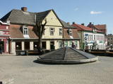 |
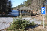
Tukums in the historical sources is mentioned in 1253 agreement of the Livonian Order and the Bishop on the division of Kursa. If the town's name is translated from the Liv language, it means "a pile, mountains of sand". at the beginning of 14th century German merchants and craftsmen settlement was formed at the Livonian Order stone castle, whose flowering was facilitated by the proximity of Riga - Prussian road. Later the city was largely influenced by the construction of Riga - Tukums railway in1877. During the Soviet period the on the eastern outskirts of Tukums, the largest Soviet military airfield and military town in the Baltic States was deployed. Today Tukums is a district centre of the same name with a wide range of services offered to tourists. |
|
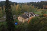 |
The history of Līgatne cannot be separated from the paper factory which was once the only factory of its kind in Latvia. Tours are available in the company of a guide. During the late 19th and early 20th century, the company built homes, a school, a birthing centre, a hospital, a club, a guesthouse and other buildings for its employees, and most of these buildings have survived to this day. There are more than 200 interesting underground passageways which are still used as warehouses for various items, including vegetables. |
|
 |
This is an area where migrating birds seek shelter and food all around the year. Seen most often here are the red-throated and black-throated loon, the common shelduck, the long-tailed duck, the velvet scoter and the little gull. The territory is also important for the protection of reefs. It lies opposite the Dundaga, Roja and Engure administrative districts, as well as the city of Jūrmala, and it covers 132,173 hectares of territory. The marine parts of the Engure Nature Park and the Ķemeri National Park are covered.
|
|
|
|
Atrodas sporta un atpūtas kompleksā „Trīssaliņas”. No torņa paveras pievilcīga apkaimes ainava, kas īpaši skaista ir pieneņu ziedēšanas laikā. |
|
 5 days
|
Historians say that the Livs or Livonians lived in the territory of Latvia long ago, starting in the 10th century. They populated Northern Kurzeme and the river banks of the Daugava and Gauja rivers. They asked the first German tradesmen who appeared in the area about the price of textiles at the market in Visby. This means that they were familiar with the island of Gotland. The Livonians were courageous and spiritually strong seafarers, because only strong men can live with the sea, go fishing and seal trapping, and take root in the by no means fertile sands of the seashore. The territory between Ģipka and Ovīši is known as the Livonian coastline. There are still romantic seashore fishing villages of Livonian origin, as well as Cape Kolka, where the great Latvian activist Krišjānis Valdemārs insisted that it was the centre of Europe. Livonians all along the seashore responded to his call by taking part in building sailing ships all the way up to Ainaži, where there was a maritime school. That allowed the ships to sail to the far corners of the world, thus creating a century of sailing ships. This wasn’t possible without the Livonians. Also on the coastline are the oldest lighthouses in Latvia, with the one at Ovīši still serving as a star that shows the route for seaborne ships that are heading for Rīga. The Livonian heritage is also seen in the tradition of fishing for lamprey eels – something that is still very much in place in Carnikava, Svētciems and Salacgrīva. Old-time fishing equipment that cannot be seen anywhere else is on display in the latter town. The Latvian nation emerged when the Livonians flowed together with the Lettigalians, the Livonians joke. It may be that there is some truth in the anecdote. Liv or Livonian culture, lifestyles and history are closely linked to Latvia and cannot be separated from it. |
|
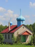 |
Vainova Old-Believers Prayer House was built in 1980 replacing the previous
church that was burnt by lightening. Initially, the Prayer House was one of the
biggest churches in Latgale (for 2 000 people). The congregation of the church
exists since the 18th century.
|
|
 |
Karulas nacionālā parka lielākais ezers - 2,8 km garš, līdz 1 km plats. Ezera ziemeļaustrumu krastā atrodas parka apmeklētāju centrs. 5,5 m dziļais ezers ir gan zivīm, gan nostāstiem bagāta vieta. Ezera un tuvākās apkārtnes iepazīšanas nolūkā ir izveidota 3,5 km garā Ehijerva taka (Ähijärve teerada). Tās sākums atrodas pie iepriekš minētā apmeklētāju centra, kur izveidota atpūtas vieta un atraktīvs bērnu spēļu laukums. Taka sākumā ved gar ezera krastu, nelieliem mitrājiem un meža ceļiem, kas izmantoti iepriekšējos gadsimtos. |
|
 |
Dabas liegumā ietilpst divi aizauguši ezeri ar grūti pieejamiem krastiem - Lielais un Mazais Asūnes ezers, kas atrodas dienvidos no Asūnes ciema. Abus ezerus var vērot, atrodoties ārpus lieguma teritorijas - no blakus esošo pauguru augstākajām daļām, kas atrodas austrumos no abiem ezeriem. Ja līdzi būs paņemts tālskatis, iespējams, izdosies iztālēm novērot šeit esošās aizsargājamās putnu sugas, piemēram, melno zīriņu. |
|
 |
Находится в Пастари, примерно на расстоянии 2,5 км от дороги Прейли - Виляны, в самом высоком месте с красивейшим пейзажем на Латгальскую возвышенность. Ветряная мельница голландского типа (с вращающимся механизмом крыльев) построена в 1902 году. В 2012 году были восстановлены крылья ветряной мельницы. По предварительной договоренности мельницу можно осмотреть изнутри. |
|
 |
The No. 521 Border Guard post at Ovīši is owned by the Defence Ministry and is closed to civilians. Visitors can only look at the ruins of some buildings in the dunes.
|
|
 |
This territory is to the North of Skrunda, and it is an important location for water birds during their migration. Northern swans nest in the ponds, and sea eagles and other birds such as falcons and plovers use them for feeding. This is a good place for bird-watching, although it has not been particularly structured for that purpose. |
|
 |
Piedāvājumā relaksācija pirtī - sildīšanās, skrubēšanās, enerģiskais pēriens, kā arī dažādas masāžas. |
|
 |
The Vecročupe river flows out of the artificial Vaide pond. It was created by blocking the Vaide and the Kukšupe rivers. This happened during the Soviet occupation, when forestry people decided to establish a fishing pond and an area for recreations. A wooden pergola has been installed at the pond, and there is an information stand, as well. On the northern shore of the pond is the Vaide cemetery, which dates back to 1928 and has interesting wooden crosses. |
|
 |
The most important aspect of the Sasaļi forest is the eutrophic Lake Sasalis, as well as the unusual Lake Melnezers. Also of importance are various types of forestland in the area. Lake Sasalis is a popular place for leisure and swimming.
|
|
 |
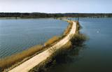
Atrodas Lielvārdes parkā pie Rumbiņas ietekas Daugavā. Līdzīgi kā citur, arī šeit 13. gs. pirmajā pusē bīskapa pili cēla nodedzinātās lībiešu koka pils vietā. Mūra pili nopostīja Livonijas kara laikā - 1577. g. Tikai 1987. g. notika drupu konservācija. Lielvārdes parka veidošanu uzsāka 19. gs. beigās Lielvārdes muižas barona Artura fon Vulfa vadībā. Sagaidot eposa „Lāčplēsis” simtgadi tajā izvietoja sešpadsmit no ozolkoka veidotas skulptūras (t.s. Skulptūru dārzs) (autori V. Ansavs, P. Mellis, Ē. Delpers, A. Dauvarte). Aiz pilsdrupām Daugavas krastā ir stāva krauja ar dolomīta iežuatsegumu. Līdz HES ūdenskrātuvei var nokļūt pa kāpnēm. Lielvārdes muižas pils līdz mūsdienām nav saglabājusies. |
|
 |
The café is situated in a comfortable cellar of a museum commemorating the life of the Latvian author Anna Brigadere. Here you will find a variety of foods and drinks that can satisfy any taste. In the summer, in the yard filled with sunshine, you will be able to relax on the outdoor terrace, listening to the waterflow of the Tervete river, whereas in winter, having enjoyed the snow drifted landscapes, warm up in the cellar, drinking tasty tea. The café organises parties with the good witches of the Tērvete forest, as well as rides in horse-drawn carts or sleds. Latvian cuisine: Pork ribs in honey sauce, pancakes with jam, mushroom sauce. Special foods: “Bear’s paw”. |
|
|
|
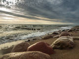
Izteiksmīgs zemesrags, kas klāts ar
dažāda lieluma laukakmeņiem.
|
|
 |
The botanic garden is part of the Siauliai University and is the newest and smallest botanical garden in Lithuania, covering 6.54 ha of land. |
|
 |
Atrodas 0,5 km ziemeļaustrumos no Dzērbenes baznīcas, ceļa otrajā pusē. Vizuāli izteiksmīgs pilskalns ar 50 x 50 m lielu plakumu, kura kultūrslānī atrastas vēlā dzelzs laikmeta apmetnes atliekas. Pilskalna rietumu nogāzē ir izveidots ceļš, pa kuru nonāksim līdz tā plakumam ar estrādi. |
|
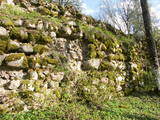 |
The Volkenberga Castle was built in the 13th century by the Livonian Order, and it was practically impregnable, as it was on top of Mākoņkalns hill. These were among the first fortifications in Latgale, and only fragments of the castle remain today. Architect Pēteris Blūms has said that this was a special type of fortification. Legends say that after the lord and lady of the castle died, the property was divided up among their three daughters – Roze, Lūcija and Marija. Each sister built a new castle on the land which she inherited – Roze built Rēzekne, Lūcija built Ludza, and Marija built Viļaka. A memorial plaque at the foot of Mākoņkalns hill recalls the visit which pre-war Latvian President Kārlis Ulmanis paid to Latgale in 1938. |
|


