
| No | Name | Description |
|---|---|---|
 |
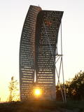
Māras birzs atrodas apmēram 4 km no Īles, Zebrenes virzienā. 2012.gada pavasarī iestādītā piemiņas birzs ir biedrības „Zebrus draugi” veltījums šīs apkaimes ļaudīm un viņu dzimtajām mājām, kas pēdējā gadsimtā ir zudušas no Latvijas kartes. Valsts meža izcirtumā iestādīto jauno kļavu, liepu un ozolu birzs centrā izveidots Māras altāris – simbolisks akmeņu krāvums, kurā katrs, kas jūt piederību šim apvidum, var pievienot savu akmeni. Birzs projekta un altāra autors - V.Lukjanovs. |
|
|
|
The mouth of the most beautiful river of Vidzeme. On the seashore between the mouths of River Gauja and River Daugava, one of the largest dune ranges in Latvia with distinctive parabolic dunes overgrown with forest (wooded dunes) is situated. The Mouth of River Gauja is unique as it is one of the few major rivers in Latvia and in EU countries to flow into the sea naturally. There is no harbour or other hydro-engineering construction. It is a popular recreation area in the vicinity of Riga and Saulkrasti while, unfortunately, the lack of infrastructure makes it suffer from anthropogenic load. Not far from the rivermouth, hidden in dunes, there are pillboxes which were built in 1920 or 30ies as anti-airborne barriers. There was a whole range of them along the coastline from the mouth of the River Lielupe to the mouth of the River Gauja forming a part of the Daugavgrīva Fortress fortifications. The pillbox is made of concrete, ca 1.5m thick. Every year, on the 3rd Sunday in August, a lamprey festival takes place in Carnikava town by the Gauja rivermouth. Carnikava is called the Lamprey Capital as it is famous for its lamprey fishing tradition and generous catches. The Mouth of the River Gauja is a good bird-watching area, especially in spring and autumn when one can observe the highest variety of species. Just few of the many bird species that can be observed near the Gauja rivermouth |
|
 |
Das Gedenkzeichen in Ošvalki, das den lettischen Flüchtlingen (1944 – 1945) gewidmet ist, die über die Ostsee in Fischerbooten nach Schweden geflüchtet sind. |
|
 |
In Ošvalki, which is between Jūrkalne and Sārnate, there is a commemorative sign, “Sail of Hope,” which commemorates Latvians who sought to cross the Baltic Sea to Sweden during the latter period of World War II in 1944 and 1945. The sign is in the dunes between the road and the sea. |
|
 |
Atrodas Vārtājas ielejas labajā krastā un labi saskatāms no Priekules – Grobiņas (P106) ceļa. Senās kuršu zemes – Piemares pilskalns, kas vēstures avotos pirmo reizi minēts 1253. gadā – līgumā starp Kurzemes bīskapu un Livonijas ordeni. Viens no lielākajiem Dienvidkurzemes pilskalniem. Iespējams, ka iepriekš – arī sens kulta kalns. Pagājušā gadsimta sešdesmitajos gados veiktajos arheoloģiskajos izrakumos konstatēts, ka pilskalns bijis apdzīvots jau vidējā dzelzs laikmetā. Pie tā konstatēta liela senspilsētas vieta. |
|
 |
Older residents say that the guesthouse is located in the centre of the Domanti village. The guesthouse has four buildings built in accordance with ethnic architectural traditions, including a granary, a sauna and a traditional residence with two ends. |
|
 |
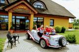
The restaurant is on the shore of the Bay of Rīga, between the VIA Baltica highway (A1) and the sea. It is part of the “Kapteiņu Osta” territory, which is surrounded by the meadows of Randa. The restaurant has a summer terrace with beautiful sunsets. Latvian cuisine: Cold beet soup, potatoes with cottage cheese and herring, smoked eel, oven-baked catfish, baked pike-perch with hemp butter, cottage cheese buns, strawberry soup. Special foods: Fish soup. |
|
 |
Jaanihanso Cider House makes cider from natural Estonian apples. Here there is a special technique applied to making the cider – the cider clears and matures as same as the best champagne in the world does. Here it’s possible to try different ciders and for additional fee, snacks to with it, as well as take a tour around the Cider House. In this case, registering one week in advance is necessary. |
|
 |
Work on the arboretum, which covers 15 hectares of land, began in 1968, and it was meant to be a landscape park. The first plants were planted in 1972. During the fierce winter of 1976, sadly, many of the plants froze. In 1987, the park was redesigned. At that time it had 234 types of deciduous trees, coniferous trees and bushes. There are signs showing the Latin and Latvian names of the various plants
|
|
 |
The museum has more than 120,000 objects which focus on the history of Liepāja and Southern Kurzeme from the Stone Age to the 19th century. Another exhibition is focused on the life and work of the wood sculptor Miķelis Pankoks (1894-1983). New art exhibitions are periodically staged at the museum. |
|
 |
Lustužkalns Hill (72 m ASL). A hunting
castle owned by Livonian Order master
Walther von Plettenberg was located here
in the 16 century. During the reign of
Russian Empress Catherine the Great, a
recreational castle was built here. A
legend from the time says that a golden
carriage is at the bottom of the local Lake
Valgums.
|
|
 |
Stūrīši is a homestead owned by the Taisel family, offering a collection and a chance to taste Liv foods: fish soup, porridge, sprat sandwiches, pastries, etc. |
|
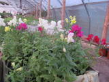 |
The farm grows and offers vegetables, annual and perennial flowers for gardens, as well as decorative bushes and trees. The owners will design gardens and other green areas, sell saplings and accept commissions for the growth of saplings. You can learn all about the secrets of growing decorative plants and receive advice from the owners. |
|
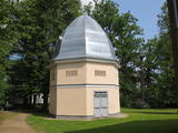 |
The creamery or clock tower (so known because a clock was installed in the round roof window of the structure) is near the gate to the Naukšēni Estate. The eight-corner brick building has a domed roof that is covered with tin. The clock tower has two floors. The second is easily ventilated because of small windows on all sides of the building. The creamery is seen in a picture drawn by J.K. Brotze around 1800. It suggests that the building has not lost its initial shape even today. The tower deteriorated during the Soviet era, when a barn was attached to it and a large gate opening was broken into it. In 2002, the tower was renovated (architect Inese Maurāne). The interior preserves the historical brick floor and the stairs to the second floor. Historical objects are displayed in the creamery, and today it is one of the main tourist attractions for the Naukšēni Estate. |
|
 |
The tower is beyond the Oleri estate, in the small Oleri swamp, where at the end of a wooden footpath you can step upward a bit and learn about the landscape of a transitional swamp. This is part of the ZBR.
|
|
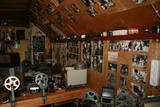 |
This is a collection of cinema and photography items collected by the owner of the Ziķu homestead in the Zirņi Parish, which is in the Saldus Administrative District. The collection includes antique film cameras and objects that demonstrate the process of taking pictures and films. The exhibition is in a log building that the owner built – one that resembles bee cells. Please contact the owner in advance for a tour. |
|
 |
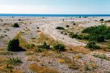
This circular trail features a unique landscape of parallel rampart-type sand dunes and grassy swamps among the dunes. The 3.5 km trail leads through a landscape that is unique in Europe and emerged some 6,000 years ago as the sea was receding. This landscape offers evidence of the geological history of the Baltic Sea. There is a high-type swamp (the Pēterzers swamp), along with remnants of an old narrow-gauge railway. Wooden pathways have been installed along the swamp and the surrounding wetlands. |
|
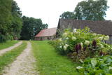 |
The Pilkalne Estate is in a remote location on the border of Latvia and Lithuania, 5 km to the Southwest of Nereta. Lovers of history certain must visit this estate. Why? One reason is that the grain kiln of the estate, which is gradually being restored, and the grain drying stove, a few wooden parts of which have been preserved, are unique in Latvia. The stable and servants’ home have also survived and are populated today. The buildings were built in the 18th century. The owner can tell you stories about interesting aspects of this location’s history. |
|
 |
This is a “peripheral” island in the Bay of Finland, 9 km from the Dirhami port. The special fact about this island is that it offers fields of juniper, a rocky and grassy seashore that is around 2 km long, and limestone cliffs that are a few metres high along the northern and the eastern shores of the island. These are designated with the words Osmussaare pank.
|
|
 2 days
|
This section of the Baltic Coastal Hiking Route is suitable to hardy hikers who like to travel across uninhabited places. In many places, reeds, floodplains with pastures and wetlands stretch across the Estonian seacoast, which is why the itinerary often leads you along forest and country roads. In the second half of summer you can pick the mushrooms and berries in the coastal forests. Pärnu is a popular resort city with many cafés, live music, SPAs, hotels and a beautiful Old Town. |
|


