
| No | Name | Description |
|---|---|---|
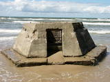 |
All that’s left of the battery today are the ruins of a cement blockhouse which have slid all the way down to the beach because of years of abuse by the wind and the waves. It is an interesting monument to history with a long-term fate that we can guess at – it will disappear under the sea.
|
|
 |
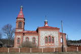
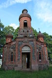
Ismeri Old-Believers Prayer House was built in 1912 by the donations of local people. The parish of
Ismeri exists since 1861.
|
|
 |
During restorations of the tower of the Kolka Lutheran church in the 1990s, a document was found which spoke to the conversion of many Livs to the Orthodox faith. The document was placed in the tower in 1885, when the church was being constructed, and it says that the decision by Livs to join the Orthodox church was based not on faith, "but instead as a resource for accessing advantages in relation to land." The Orthodox congregation purchased land from a local aristocrat in 1885, and in 1990, a church, manse and school were built on the land. All three buildings have survived to the present day. The church has its own congregation, and worship services are held once a month. There are news to show that Kolka is the only Liv shoreline village in which an Orthodox church was built during the 1890s. The church's bell dates back to 1936. During the Soviet era, the church was used as a mortuary, but today its original functions have been restored to it. |
|
 |
The Apakšceļs road – a lonely, forested and ancient road between
Košrags and Dūmele, with lots of interesting stories about the old Pitragupe
windmill, which never did grind any grain (the foundations are still there), and
about the boiler of a wrecked ship which a local baron used to produce tar.
This used to be a horse path which crossed the Bažas swamp. The great rock
of Dūmele is impressive, indeed.
|
|
 |
Ar mežiem, purviem un ezeriem (Riču, Sila u.c.) bagāta teritorija Latvijas - Baltkrievijas pierobežā. Galvenās aizsargājamās dabas vērtības - dažāda veida purvu, mežu un ezeru biotopi un tajos mītošās augu un dzīvnieku sugas. Ezeru krastos, kurus iecienījuši vietējie atpūtnieki, atrodas vairākas naktsmītnes. Ilgas muiža (celta 19. gs. kā medību pils) ir Daugavpils Universitātes studentu prakses vieta. Silenes dabas parkā ietilpst arī Glušonkas purva un Ilgas dabas liegumi.
|
|
 |
Dievnamu (atrodas Skujenes – Vecpiebalgas ceļa malā) 1872. g. cēla pirmais izglītotais latviešu arhitekts Jānis Frīdrihs Baumanis (1834. – 1891.), kas ir vairāku pazīstamu celtņu – J. Vītola Mūzikas akadēmijas, Rīgas cirka, Valsts bankas u.c. ēku projekta autors. Padomju laikā Māļu baznīcā atradās tukšās taras pieņemšanas punkts, bet mūsdienās – saglabājies tikai ēkas ārējais veidols. Baznīca apskatāma arī no iekšpuses. |
|
 |
The tree farm focuses on decorative plants, including summer and perennial flowers, fern and collections of peonies. Flower containers and pyramids are made on order. The farm delivers and installs vertical “green walls”. The farm also offers Christmas products and materials for floral design. |
|
 |
This is the ancient shore of the Baltic Ice Lake. We can only imagine the landscape 10,000 years ago, when the Kurzeme peninsula was covered with vegetation reminiscent of a tundra, and waves from the icy lake dashed against the ancient shoreline. We know that the lake was full of icebergs of various sizes. Today the cliff is more than 20 km long (some 9 km of it are in the Slītere National Park), and it is as much as 42 m high. It is the most impressive cliff of its type in all of Latvia. At the foot of the cliff are the Irve flatlands (the name comes from the Liv 'īrva' or 'īra', both of which refer to deer). The flatlands are the former bottom of the Baltic Ice Lake. The Blue Hills are crossed by many small streams and rivers (Pitragupe, Lorumupe, Kaļķupe, Mazupe, etc.). Their valleys are the basis for a branched and very complicated system of waterways which look particularly impressive when the trees are bare. In many places the cliffs and valleys display small areas of sandstone from the Narva suite. These are Latvia's oldest sediment cliffs that can be seen above ground. Although the Blue Hills are very impressive in scope, there are only a few places where there are important viewing areas (a viewing tower at the Dundaga-Mazirbe road, the view from the Šlītere lighthouse, the view from Mežlīdumi). The mightiness of the ancient shoreline can truly be enjoyed from the Cirste-Mazirbe road, the Cirste-Riepaldi road, Mežlīdumi and the Vīdala-Melnsils road). It is worth visiting the area in the springtime, when the slopes of the Blue Hills seem to be sinking under the fresh greenery. |
|
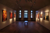 |
The Daugavpils Mark Rothko Art Centre is a multi-functional institution of culture, arts and education, located inside of the fortress' Arsenal building. It is a unique place in the Eastern Europe, where are located the original paintings of Mark Rothko – a great artist of the XX cent., a founder of the abstract expressionism movement, best known for his enigmatic color field paintings. |
|
 |
Pajumäe is a small, nice organic farm located in the green Mulgimaa, and produces various dairy products. You will have the opportunity to look at all stages of milk production - from cows on the pastures to dairy processing. |
|
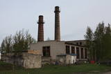 |
The boiler house of Karaosta has been used for decades to ensure heat for the city of Liepāja. Although it is part of the heating network, the facility is not guarded and has largely been abandoned.
|
|
|
|
This is the grave of the
parents of Captain A. Bertholds with an unusual grave monument.
|
|
 |
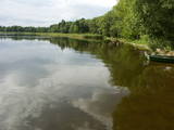
The complex is on the northern shore of Latvia’s second-largest lake, Lake Rāzna. The windows of the “Kastānis” café offer a view of one of the loveliest lakes in the country. |
|
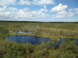 |
This is one of the largest high-type swamps (6,192 ha) in Latvia, with very distinct landscapes of little lakes and hillocks. The Great Ķemeri Heath is of importance as an extensive hydrological system and preserver of the local microclimate. It is also of international importance as a site for birds, as well as a major source of sulphurous water. Along the Kalnciems-Kūdra road, which is on the eastern edge of the swamp (3.4 km from the Rīga-Ventspils highway), there is an information stand with information about the management of the heath and about the role of swamps in nature and in the lives of people. Great Ķemeri Heath wooden pathway trail is now restored and opened for visitors in 2013. |
|
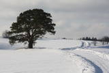 |
This is an unusually shaped pine which, according to legend, was planted by the king of Sweden during the Great Northern War.
|
|
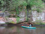 |
The Brasla River flows through a lovely valley that is approximately 300 m wide and up to 30 m deep. It is near the Inčukalns-Valka highway. The river has among the most beautiful rapids in the country, with mighty cliffs (the Brasla cliffs) that can be seen at nearly every curve in the river (except along the lowest reaches of the river). During the winter, various unusual frozen waterfalls can be seen in some of the cliffs, including the Krauļukalns cliff and the Jāņavārti cliff. On the left bank of the Brasla, opposite the Brasla fish farm, there are the Aņīte cliffs -- a series of sandstone cliffs that are 1 km long. The cliffs are between 2 and 35 m in height, and the sandstone cliffs are separated by ravines. On the right bank of the Brasla, there are major cliffs such as the Vāršavu cliff, the Kraukļukalns cliff, the Jāņavārti cliff, the Slūnu cliff, the Virtaka cliff and the Buļi cliff. How can you best learn about them? Boat down the river from the aforementioned highway or even from Straupe, which is further upstream. An alternative is hiking down the right bank of the river, though please take into account that the terrain is fairly extreme, and you are going to have to think about what to do when you arrive at the place where the Brasla River flows into the Gauja. |
|
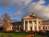 |
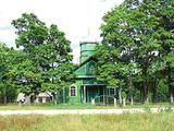
The Krimulda Estate was first recorded in documents in the 15th century. The Krimulda Castle that can be seen now is on the right bank of the ancient Gauja River valley opposite the aerial tram. There are outstanding views of the ancient river valley from the castle and the opposite shore. The Krimulda Castle is a Neo-Classical structure which was built by a local nobleman in the 19th century. In the 1920s, the castle was expropriated and turned over to the Latvian Red Cross, which installed a children's sanatorium there. Today the Krimulda rehabilitation hospital is in the building, and among other structures, the ones that have survived include the stables, threshing barn, servants' quarters, governor's quarters, and the so-called Swiss house. Educational tours are available, and overnight stays are possible at the estate. |
|
|
|
Pokaiņu mežs atrodas 13 kilometru attālumā no Dobeles, braucot Īles virzienā. Tas, izvietojies uz stāviem pauguriem un dziļām ielejām, veido neparasti gleznainu ainavu. Mežā grupās, kaudzēs, akmens upēs un valnīšos, atrodas slavenie Pokaiņu akmeņu krāvumi. Krāvumi daudziem cilvēkiem liek sajust savdabīgus enerģijas strāvojumus - vieni redz vīzijas, bet citi – uztver informācijas plūsmu. Takas ved pa pagurainu apvidu.
|
|
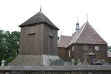 |
Iespaidīga koka celtne un izcils koka arhitektūras piemērs, kuru pamanīs katrs Plateļu apmeklētājs! Plateļu baznīca ir viens no Lietuvas vecākajiem koka dievnamiem. Pašreiz redzamais ir būvēts 1744. g., bet zvanu tornis – 1899. g. Dienvidos no baznīcas plešas Plateļu muižas parks. |
|
 |
The area is in the centre of the Teirumnīki swamp, alongside a lake of the same name. There is a wooden footpath that crosses the swamp (800 metres). This is an excellent opportunity to study a high swamp, a swamp lake, and the surrounding environment.
|
|


