
| No | Name | Description |
|---|---|---|
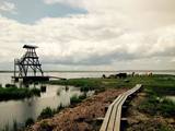 |
Engures apkaimē aug 22 no Latvijā sastopamajām 32 orhideju dzimtas sugām .Lai dabas parka apmeklētājiem dotu iespēju aplūkot šīs interesantās augu sugas, ierīkota Orhideju taka. Kopējais takas garums ir 3.5 km, tā sākas netālu no Engures Ornitoloģisko pētījumu centra, līkumo caur kalcifilajiem purviem un mežam putnu novērošanas torņa virzienā, un aizvijas tālāk gar atjaunoto ezera piekrastes pļavu, kurā mīt govis un zirgi. Takas sākumā novietotajā informācijas zīmē attēlotas ne tikai apkārtnē sastopamās orhidejas. Tur iespējams gūt daudzpusīgu informāciju arī par citām interesantām Engures ezera dabas parka augu sugām.
|
|
 |
An organic farm where it is possible to read and taste strawberries directly from the field during the season. There are also real wild strawberries. Sea buckthorn is also grown, can be read and tasted in September. Small-scale processing (juices, syrups, frozen products, jams) - home producer status. |
|
 |
Wooden slat weaving workshop is located in Jelgava county, Sesava parish. Craftswoman is making different type of wooden slat baskets and basketry from pine, linden, aspen and black alder. There are several different categories of baskets, available in different sizes - picknick baskets, baskets for berry and mushroom picking, trays, baskets for firewood, laundry baskets, onion / garlic baskets, baskets for kids, and diverse baskets for daily use. Various inscriptions and drawings are also made on the weavings. They also accept orders for individual orders. In the workshop it is possible to see the wooden slat basket weaving process as well as have the opportunity to learn to make your own basket. |
|
 |
Находятся в 100 м к юго-востоку от Приекульского замка. Символ Приекуле, изображенный на гербе города. Ворота (1688 г., отреставрированы в 1954 г.) служили в качестве сторожевой башни сквозных ворот Приекульской господской усадьбы, где проводился досмотр торговцев (таможня), отправляющихся или приезжающих из Литвы. Интерес представляет родовой герб баронов Корфов выполненный в XVIII веке из голландского песчаника, с серебряным ядром и своеобразный маскарон в центральной части фасада. Во времена баронов в нишах по обеим сторонам стояли двухметровые, выполненные в камне, грозного вида фигуры стражников - солдат. Сегодня на их месте стоят деревянные фигуры стражников. |
|
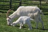 |
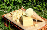
The herd consists of around 200 goats. The owner will tell you a humorous story of life with goats in Latvia and Europe, the story of making goat cheese and the secrets of its taste, will invite you to try cheese which you will be able to buy later. Goat cheese that is made in Lielgrodes is not only healthy, but very tasty. |
|
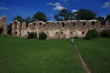 |
On the right bank of the Bērze River and in the western part of Dobele, the castle hill and its fortified forecastle were occupied between the 10th and 13th centuries, with an ancient town at its foot (currently the square between Tērvetes Street and the Liepāja highway). As was common, the Livonian Order used this ancient Semigallian castle hill to build a brick castle between 1335 and 1347. The castle was sacked during the 18th century, and its fairly impressive and beautiful ruins have been conserved. A viewing platform is part of the charm. |
|
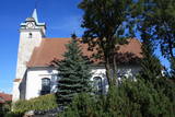 |
The church was built between 1640 and 1642 as a mark of respect for the king of Poland. It was commissioned by Duke Jacob Kettler and has a confessional bench with allegoric paintings (1691), as well as three altars decorated with Rococo carvings. There is a 16th century sculpture of the Madonna and her child. Contact the church for a tour. |
|
 |
This guesthouse is on Rusen Island near the shore of the Pakalne River. The owners collect plants, process them in accordance with folk recipes, and then offer various teas, infusions and other beverages that have medicinal properties to improve people's moods and their tonus. |
|
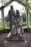 |
The monument is next to the Vecpiebalga Cultural Centre. Its architect was Ausma Skujiņa, and the sculptress was Maija Eņģele. |
|
 |
The Lapmežciems Museum features
information about the history of the local
parish, its school and its fishing industry.
There are also exhibits featuring World
War I battles near Klapkalnciems which
involved Finnish soldiers. The museum
also organises themebased exhibitions.
Alongside it is a memorial rock for the
politically repressed.
|
|
 |
The space is on the second floor of the Jūrkalne library, featuring traditional objects from Jūrkalne and the Suiti people, as well as several looms where locals organise creative workshops. Contact the chamber in advance to arrange for a guide who will tell you all about the culture and traditions of the Suiti and present a film about them. |
|
 |
This summer terrace café is on the beach of the Preiļi park, and it offers 100% natural ice cream with berries, as well as fresh pancakes. The café is only open from Mother’s Day (May 8) until Father’s Day (September 11). Tourist groups are offered tours and tastings of cheese-based ice cream. |
|
 |
The Lejasmalas leisure base is on the banks of Lake Leja with a beautiful view of islands in the lake. It offers Lettigalian dishes made of locally soured products. |
|
 |
Pirts noma, izmitināšana, ēdināšana, banketu zāles noma, internets, makšķerēšana, volejbola laukums. |
|
 |
The farm is on the Right Bank of the Venta River. It breeds goats and makes cheese. Visitors can taste the cheese and buy products. Orders are accepted in advance. |
|
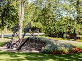 |
Parkā blakus pusloka tiltiņam ir novietotas trīs milzīgas dzelzs atslēgas, kuras balsta akmens mūris un metāla arkas. Tās simbolizē trīs vēsturiskos centrus un to vienotību – Siguldu, Turaidu, Krimuldu. Dobēs pie šī objekta sezonāli zied dažādi kultūraugi. |
|
 |
The central part of the town of Krāslava is an historical monument because its low-story and beautiful wooden buildings. The best views of the historical centre relate to the carp park near the Adamova trail, the Karņicskis hill, the bridge across the Daugava (Prospekta Street), and the Priedaine viewing tower on the left bank of the Daugava River. |
|
 |
The first mention of Pēterupe Rectory goes back to the late 17th century. The Manor Park and the buildings have partially survived to the present day, including a linden alley at the end of Smilšu Street, planted by the pastor Jānis Neilands in 1879 and the grand oak planted by Johann Wilhelm Knierim in 1869. After the fire of 1908, the Rectory was restored and partially rebuilt. In Soviet times, the property was removed from the parish and the house was named “Līgotnes”. During German times the Rectory was occupied by legionnaires. After the war, the building of the Rectory was turned into a hospital, then into a secondary school and later it was transformed into a block of flats for teachers. Now the building again belongs to the parish and it is inhabited by a priest of the parish and his family. |
|
 |
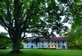
The Švekšnos Estate and its park are among the most beautiful venues of this type in Žemaitija. Alongside the estate is an impressive park, with two segments that are linked by a wide parade staircase that is decorated with vases and offers a lovely view of the lower terrace. On an island I the central pond of the park is a statue of the goddess Diana. A colourful sundial, a vase on a pedestal, a sculpture of St Mary, and a sculpture called "Angel of Freedom" are all found in the park. Other elements, including viewing areas, pathways and gates have also been restored. |
|
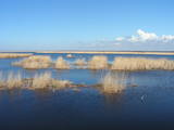 |
This is a shallow lagoon-type lake which, along with the area around it, is a wetland of international importance. The presence of 271 species of birds has been found in the area, including 43 birds which are listed in the Latvian Red Book and 15 that are listed in the European Red Book. The nature park includes the Nida swamp and the part of the sea which is alongside the park - newly estabilshed sea protected area "Nida - Pērkone". Between Lake Pape and the Baltic Sea we find Latvia’s oldest bird ringing station, where rings are attached not only to birds, but also to bats. Lake Pape is the first territory in Latvia where livestock adapted to life in the wild have been released for the proper management of the lake’s flood-land meadows. First there were wild horses (“Konik” horses), then aurochs and the European bison. Visitors can use bird and nature observation towers, nature trails, etc. The Ķoņi village is a unique example of a seaside fishing village. Pape is popular among bird-watchers, and the park’s visitors centre is found in the “Nature House” of the Worldwide Fund for Nature. |
|


