
Flüsse
Flusstäler und andere bemerkenswerte Orte.
| Überblick | Details |
|---|---|
 |
Lettland
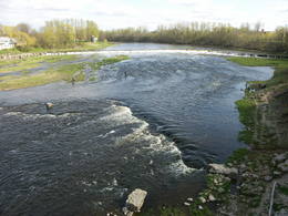
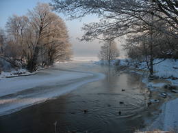
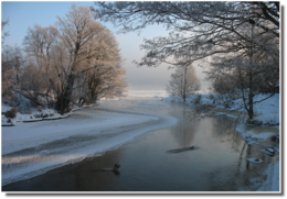
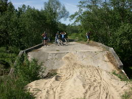
Ventas ielejaÜber- und unterhalb der Stadt Kuldiga zeichnet sich die Venta durch eine Vielfalt an Biotopen aus – Hangwälder, Sandstein- und Dolomitklippen, Wiesen, geschützte Pflanzen und Tiere und verschiedene Landschaften. In diesem Teil Kurzemes gibt es beliebte Tourismusobjekte – den Wasserfall der Venta, die Backsteinbrücke von Kuldiga, den Burgberg von Veckuldīga usw. Ein ökologischer Tourismuspfad führt an den Ufern der Venta entlang und eine Fahrradroute wurde an seinem linken Ufer eingerichtet.
Leistungen
150km - Entfernung von der HauptstadtLeistungen - erholung
AngelnVentā saskaņā ar esošo kārtību.

FahrräderKuldīgas TIC.

RadrouteVelomaršruts "Ventas ieleja" daļēji ietilpst dabas lieguma teritorijā. 
NaturpfadEkotūrisma taka "Ventas līkloči" ar nepieciešamo labiekārtojumu un sezonālu pārceltuvi pāri Ventai. 
NaturbeobachtungVentas krastos, pie Ventas rumbas (īpaši, migrējošās vimbas!).
|
 |
Lettland
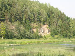
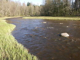
Ventas un Skervela ielejaDas ist eine der schönsten Gegenden entlang der Venta und ihrem Nebenfluss, dem Šķērvelis. Die Flusstäler und ihre Schluchten sind ziemlich tief. Dolomit- und Sandsteinklippen kann man hier und dort ausmachen, auch Stromschnellen gibt es im Fluss. Die größten Felsen in Kurzeme – die Ātraiskalns- und Gobdziņi - Felsen – befinden sich an den Ufern der Venta. Die katholische Kirche Lēni ist in der Nähe des geschützten Gebietes. Die Venta ist ein beliebtes Ziel für Wassertouristen, vor allem der Abschnitt zwischen Nīgrande und Kuldīga.
|
 |
Lettland
Vecrocupe, Vaide PondThe Vecročupe river flows out of the artificial Vaide pond. It was created by blocking the Vaide and the Kukšupe rivers. This happened during the Soviet occupation, when forestry people decided to establish a fishing pond and an area for recreations. A wooden pergola has been installed at the pond, and there is an information stand, as well. On the northern shore of the pond is the Vaide cemetery, which dates back to 1928 and has interesting wooden crosses. 173
Leistungen
173km - Entfernung von der Hauptstadt |
 |
Lettland
Versupite (Fluss)Vēršupīte (Fluss) – die Brocēnu Straße überquert die
Vēršupīte, die sich durch Ķemeri windet. Sie ist mit 12
kleinen und romantischen Brücken beschmückt. Jede
der Brücken hat einen Namen.
47
Leistungen
47km - Entfernung von der Hauptstadt |
 |
Lettland
Slocene (Pulkaine)The Slocene River flows through Lake Valgums and Lake Mazezers before flowing into the western part of Lake Kaņieris. It is part of a branched and swampy delta in which there are seasonal restrictions aimed at protecting birds. The wetlands which are alongside the river are difficult to access in many places. Before the Starpiņupīte was dug between Lake Kaņieris and the Bay of Rīga (the water level is regulated with sluices), the water from the river flowed along what is now the Vecslocene River all the way to Sloka, where it ended at the Lielupe River. The Vecslocene can be used by canoe boats only when the water level is high and then from the Old Ķemeri road to the place where the river enters the Lielupe. Between Milzkalne and Lake Valgums, the river is not navigable because of many fallen trees. During the springtime, the estuary of the Starpiņupīte is a good place for bird watching. 59
Leistungen
59km - Entfernung von der Hauptstadt |
 |
Lettland
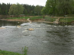
Ogres ielejaDer Naturpark im Tal des Ogre-Flusses befindet sich im mittleren Abschnitt des Flusses. Er wurde eingerichtet, um das unregulierte Flusstal und das ihn umgebende Territorium sowie die biologische Vielfalt mit dem Lebensraum zu schützen. Zum Beispiel das Gebiet, in dem seltene park-typische Wiesen vorhanden sind. Der Ogre-Fluss ist einer von Lettlands beliebtesten Flüssen für Wassertourismus im Frühling, besondern flussabwärts des Ortes Ērgļi, wo die technisch kompliziert zu befahrenden Braži – Stromschnellen sind.
Leistungen
60km - Entfernung von der HauptstadtLeistungen - erholung
Fahrten mit Schiff/BootŪdenstūrisma maršruts pa Ogri, sākot no Ērgļiem (g.k. pavasara palos).
RadrouteDivi nemarķēti velomaršruti Ērgļu apkārtnē, kas daļēji ietilpst dabas parkā. Sīkāka informācija hotelī "Ērgļi".
NaturpfadAkmeņupītes taka, kas nezinātājam grūti atrodama.
NaturbeobachtungOgres krastos - faunas un floras vērošana, kā arī apkārtnē esošajās dabas takās.
|
 |
Lettland
StarpinupiteStarpiņupīte – eine künstlich
geschaffene Verbindung zwischen dem
Kaņieris und der Rigaer Bucht, wo
heutzutage der Wasserpegel vom See mit
erneuertem Schleusensystem gesteuert
wird.
46
Leistungen
46km - Entfernung von der Hauptstadt |
 |
Lettland
ZiemelgaujaDas ist ein Territorium, das einzigartig in der lettischen und baltischen Ebene ist und das sich zwischen Valmiera und der Region von Gulbene erstreckt. Hier befindet sich das unbegradigte Gauja-Flusstal mit einem dichten System von alten Nebenflüssen. Die Wiesen auf den Flussbänken sind wichtig für die biologische Vielfalt. Hier gibt es Bestände an Eichen und Laubbäumen. Viele seltene und geschützte Vögel leben und nisten hier – der Wachtelkönig, der Specht usw. Das Territorium ist ausgezeichnet geeignet zur Vogelbeobachtung, für Naturstudien, ökologischen Tourismus und für verschiedene Arten des aktivem Tourismus.
Leistungen
110km - Entfernung von der HauptstadtLeistungen - erholung
Fahrten mit Schiff/BootMazāk populārs un tūrisma infrastruktūras ziņā ne tik labiekārtots ūdenstūrisma maršruts no Virešiem līdz Valmierai.
NaturpfadŠobrīd Ziemeļgaujas aizsargājamo ainavu apvidū trijos pagastos ir izveidotas dabas takas.
NaturbeobachtungGaujas krastos un dabas takās.
|
 |
Lettland
Der Kanal von KauguriDer Kanal von Kauguri ausgegraben
1933, mit dem Ziel das Gewässer von Džūkste
und Slampe nach Lielupe abzuleiten, zur
Abwendung vom Versumpfen.
50
Leistungen
50km - Entfernung von der Hauptstadt |
 |
Lettland
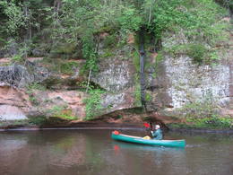
The Brasla River valleyThe Brasla River flows through a lovely valley that is approximately 300 m wide and up to 30 m deep. It is near the Inčukalns-Valka highway. The river has among the most beautiful rapids in the country, with mighty cliffs (the Brasla cliffs) that can be seen at nearly every curve in the river (except along the lowest reaches of the river). During the winter, various unusual frozen waterfalls can be seen in some of the cliffs, including the Krauļukalns cliff and the Jāņavārti cliff. On the left bank of the Brasla, opposite the Brasla fish farm, there are the Aņīte cliffs -- a series of sandstone cliffs that are 1 km long. The cliffs are between 2 and 35 m in height, and the sandstone cliffs are separated by ravines. On the right bank of the Brasla, there are major cliffs such as the Vāršavu cliff, the Kraukļukalns cliff, the Jāņavārti cliff, the Slūnu cliff, the Virtaka cliff and the Buļi cliff. How can you best learn about them? Boat down the river from the aforementioned highway or even from Straupe, which is further upstream. An alternative is hiking down the right bank of the river, though please take into account that the terrain is fairly extreme, and you are going to have to think about what to do when you arrive at the place where the Brasla River flows into the Gauja. |
 |
Lettland
The River KisupeThe River Ķīšupe (length – 31 km) begins its journey in the marshlands of Lēdurga Parish. As the river reaches the seashore, its bed and the location of its mouth often changes. One of the tributaries of the Ķīšupe carries a rather interesting name – Pupaļurga. The name of the River Ķīšupe probably comes from the name of a man and his house. In the 17th century a man named Ķīsis (in English: ruffe) used to live by the river. 47
Leistungen
47km - Entfernung von der Hauptstadt |
 |
Lettland
Fluss VilkupeDer Fluss ist klein, aber hat ein großes Tal, das von der Straße Vecumnieki – Ilūkste durchquert wird. Der Name des Flusses Vilkupe ist mit dem ehrgeizigen Plan des kurländischen Herzogs Jacob verbunden, die Flüsse der Flussbecken von Daugava und Lielupe zu verbinden. Die Arbeiten an dem Verbindungskanal wurden angefangen, aber das Projekt wurde nicht realisiert. Der Fluss Vilkupe war in diesem Projekt als ein Teil des Verbindungskanals vorgesehen. In Bezug auf diese Tatsache ist es wert, über die Größe der Ideen und Innovationen eines kreativen mittelalterlichen Menschen nachzudenken. Ungefähr 4 km von der Ortschaft Vilkupe ist ein Fragment des Kanals markiert und zu besichtigen. 155
Leistungen
155km - Entfernung von der Hauptstadt |
 |
Lettland
The River PeterupeThe River Pēterupe (46 km long) in its lower reaches flows by the sea, and it is one of the longest parts of the river along the picturesque coastline. In the past the River Pēterupe had several names: Pērļupe, Tarupe, Tara (in Livonian: the River of God or the Holy River). The historic area of Saulkrasti – Pēterupe Village was located on the right bank of the River Pēterupe. 50
Leistungen
50km - Entfernung von der Hauptstadt |


