
| No | Name | Description |
|---|---|---|
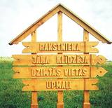 |
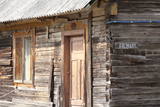
„Upmaļi” is the family house of writer Janis Klīdzējs who has written 8 novels, 11 storybooks, 2 essay books
and reflections about Latgalian catholic-Latvian mentality. Janis Streičs (famous Latvian film director) shot a film
based on the novel of Janis Klīdzējs called „The Child of a Man”.
|
|
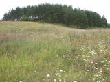 |
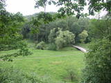
This partly forested hillock stands 40 metres above the surrounding area and offers impressive views. The fact that this was once a castle hill is attested by the presence of a moat and remnants of defensive fortifications. It is thought that Lettigalian tribes settled here in the 10th century AD. You can climb the hillock to take a look at the surrounding landscapes. |
|
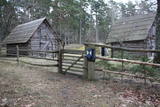 |
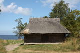
Approximately 200 metres to the North-East from the Liv People's Centre, along the Mazirbe-Košrags road, there is the Seppes homestead. The little log granary was built in the 1920s and 1930s by an Estonian fisherman and builder who arrived in Mazirbe from Saaremaa. He was called Jēkabs Jaga. On the other side of the road is the Kalši home, which was built in the early 20th century. It has been restored, but the bricks that were made in a local kiln were preserved for its walls. |
|
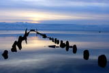 |
Kaltene features several homes where shipbuilders used to live – Caurnāši, which was home to the Bertliņi family, Ilmati, where six ailing ships were built, Maizītes, where the Stahl family of ship builders built 16 two-mast and three-mast ships, and Dambekalni, which was once one of the first canned fish factories on the coastline. To the side of the sea are the old boat piers of Kaltene. In 1936, a board pier was built by the Freijs family from Roja. It was 200 m long and had room for some 50 boats. All that is left are wooden poles that have been eaten away by the sea and time. If you want to learn about the specifics, difficulties and challenges of fishermen today, visit Ervīns Vilciņš in Ķirķrags. He will tell interesting stories on the basis of his experience. You can watch as he fishes in the morning and then taste the fish that he has caught. (Source: Roja TIC) |
|
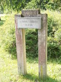 |
Marking of the Jānis Lībietis Alley in the
Ķemeri Park – Lībietis directed the institution
which managed the Ķemeri sulphurous springs
from 1928 until 1944, and the monument to
him is at the end of the Jānis Lībietis Pathway
|
|
 |
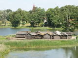
Altja village in Lahemaa National Park was first recorded in writing in 1465. It is a typical seaside village with houses along one street. Traditional farmsteads of Uustalu and Toomarahva from the late 19th C are open to visitors. Renovated fishnet sheds are located on Altja Cape. The village has a swing and a tavern (Altja Kõrts) providing national food |
|
 |
This was an island after the Rīga hydroelectric power plant created a reservoir, and before that it was a peninsula on the Left Bank of the Daugava. During World War I, there were massive battles between Latvian Riflemen and a much larger German army on Death Island. On December 25, 1916, the Germans used poisonous gas against the Latvian troops. In honour of this, the architect Eižens Laube designed a monument to fallen Latvian riflemen on the northern shore of Death Island. It was unveiled in 1924. Death Island can be reached by boat, and the trenches and graves there are of interest. There is a pier for boats on the north-western shore of the island, and nearby is a location for leisure. Some of the trenches and dugouts have recently been restored. The battles were described by Aleksandrs Grīns in his masterpiece, “Snowstorm of Souls.” |
|
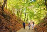 |
Šis ir viens no retajiem ceļiem, kurš saglabājies kā notikumu liecinieks. Ceļš ved no Krimuldas uz Siguldu. Jau vācbaltu apgaismotāja novadpētnieka – mākslinieka Johana Kristofa Broces 1794. gada zīmējumā "Siguldas un Krimuldas pilsdrupas" redzams lauku ceļš gar Krimuldas pili, pa kuru iet zemnieks un darba ratus velk zirgs. Lai braukšana pa Gaujas senlejas nogāzi ar zirga pajūgu būtu droša, ceļu izveidoja līkloča formā, tā uzbrauktuvi padarot daudz lēzenāku. Domājams, ka ceļš atjaunots 19 gs., kad Krievijas cars Aleksandrs otrais un viņa sieva ieradušies uz vizīti siguldā. Pāri ceļam bijuši vairāki mazi tiltiņi, ko iedzīvotāji dēvējuši par velna tiltiem. Tagad serpentīna ceļš kļuvis par romantisku pastaigu vietu. |
|
 |
Vāldamõ – a residential building that is yellow and has natural roofing materials. It was built as a new farm at the beginning of the last century. Virgo is the next homestead to the North from Vāldamõ, and it was established as a new farm in the 1920s. The house (1930) features interesting wood carvings. Next to the North is Fīlmaņi, which has a building that appears antique, but was built in the early 20th century as a single roof. Silkalni is the homestead that we find if we turn to the right toward Pitrags at the crossroads. The yellow building was built around 1906 as a single room. Norpiedagi is to the South from Silkalni – a brown and larger house than the previous one. The home was built around 1906 as a one-room granary by the active Liv public activist and boat builder Diriķis Volganskis (1884-1968). His son, Edgars Valgamā, who was also a Liv cultural activist and worked as a pastor in Finland, was born here. Anduļi can be found at the aforementioned crossroads. This is one of the largest old farms in the village, and it is owned by the village elder. The history of the homestead was first recorded in 1680, when it was called Kūkiņi. The homestead includes a residential building (c. 1909), a threshing barn (1905), a granary (mid-19th century), and a smokehouse made of a boat that was cut in two. Under the part of the threshing barn which is on the back of the dune, there is the medieval, so-called Plague cemetery. Žoki is a homestead that is on the other side of the road from Anduļi. The building that is there now was built on the foundation of an older one. In the mid-19th century, Žoki was home to the first reading school for Liv children from the seashore villages of the Dundaga region. Liv Nika Polmanis (1823-1903) worked there as a teacher. Next to the North of Žoki is the Tilmači homestead, with several buildings that were built in the late 19th and early 20th century – a brown residential building, a stable and part of a granary. When the residential building was restored, the owner found a board reading "1825. Kurlyandskaya gubernya." The seven historical homesteads and buildings were at one time considered for listing on the UNESCO list of world heritage. |
|
 |
A straight street which runs through Ķemeri in the northwestern-southeastern direction. The street's name is a proof that it is the former historical boundary between the regions of Vidzeme and Kurzeme. Near the intersection of Robežu and Tukuma streets, you can notice the former pharmacy building-the memory of the former resort of the all-union significance. On the walls there has survived the pharmacy-related symbolism. |
|
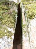 |
The Vējupīte ravine is meant for those who are not afraid of long and steep wooden stairs of the type that lead you up and down the ravine. From the Līvkalns guesthouse, you can climb the stairs downward, where you will find a shallow (3.6 m) but high (6.1 m) cave – the Pēters Cave. It is something of a gap or a niche. Another 10 minutes or so downstream (toward the Gauja) will lead you to the deep Pūces ravine and its Kraukļupīte River. The Satezele castle hill is at the confluence of the two rivers (90 x 75 m). A wooden castle was there during the feudal era in the early 13th century. Its main entrance was on the western side of the castle hill. You can get to the hill from the depths of the ravine via a wooden staircase. The Kraukļi ravine, in turn, is accessible if you climb down the same stairs and continue on your way toward the Gauja. The ravine is found on the left bank of the Vējupīte, and its sandstone walls are up to 11 m high. The Kraukļi cave, which is 5.2 m deep, is on the wall. Another 10-15 minutes (crossing the Vējupīte on a wooden bridge), and you will find another staircase leading you to Paradīze Hill (see the description above). |
|
 |
Beliebte und eine der ältesten Straßen in Jurmala zwischen Dzintari und Majori. Die 1,1 km lange Straße mit Wirtshäusern, Sommercafés und Souvenirladen. |
|
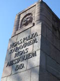 |
This is a sand dune that is covered with pines and has a monument to soldiers from Company 6 in Rīga, who defended the city in 1919. It was from this place that the soldiers went into battle against the numerically much larger army of Bermont-Avalov to liberate Rīga and its Pārdaugava neighbourhood. Created by the sculptor Kārlis Zāle, the monument features a wall facing Slokas Street that is 12 metres tall and is a depiction of the head of a lion that was once part of the gates to Rīga. The side walls on both sides have bas relief depictions of Ancient Latvians and soldiers from 1919. Atop the dune is an area with an altar, a sacrificial dish, and a memorial plaque to commemorate those who fell in battle. The monument was unveiled in 1937 by President Kārlis Ulmanis. |
|
 |
Neliela apdzīvota un ainaviska vieta plašajā Skrobļa (Skroblus) strauta ielejā. Ciema austrumu pusē atrodas Lietuvas mērogā unikāls objekts – klēts - rija, kur no 1929. g. vietējie cilvēki uzveda un skatījās lauku teātra izrādes. Netālu no tās (uz abiem objektiem ir norādes) atrodas Skrobļa avoti (Skroblaus versmės), kas iztek no dziļas starppauguru ieplakas. Avotu gan ir appludinājis bebru uzceltais dambis. Dienvidos no ciema atrodas vecs grants karjers, kas ir viena no retajām vietām Baltijā, kur dabā ir atrodami krama ieža gabali, kas atnesti ar ledāju. |
|
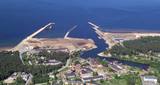 |
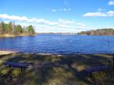
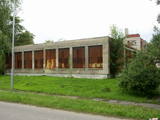
In the 19th century at the seaside of Skulte, a small village formed, which was inhabited by fishermen. The name “Zvejniekciems” (Fishermen’s village) arose from the population's main activity. In 1967 the Skulte part of Zvejniekciems was added to the Saulkrasti township. Nowadays Zvejniekciems is the home of Skulte Port, and the rocky beach of Zvejniekciems is located between the port and Saulkrasti Beach, while the village itself can be proud of the creative heritage left by the architect Marta Staņa (1913–1972). |
|
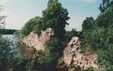 |
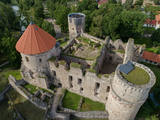
The castle hill is an island in the reservoir of the Pļaviņas hydroelectric power plant, and it can be accessed by boat. The ancient Selonian castle hill was settled several times between the 6th and the 12th century. This was the political and military centre of the Selonian region. In 1373, the Livonian Order built a stone castle on the hill, as it did on many other ancient hillocks. The castle was sacked in 1704 during the Great Northern War. Remnants of a square tower, a guard room and the 12 m embankment that once protected the castle are all that survive. Approximately 300 m to the North of the Sēlpils castle hill is Oliņkalns hill, which is underwater. |
|
 |
Svētkalnā atradusies krustnešu nocietinātā pils. Zemgaļiem to nebija pa spēkam ieņemt, tādēļ, nodedzinādami savu pili Tērvetes pilskalnā (1286. g.), tie aizgāja uz Raktes (Žagares) novadu Lietuvā. Kad Svētkalna nocietinājumi bija zaudējusi savu militāro nozīmi, krustneši to nojauca. 1701. g. Ziemeļu kara laikā Svētkalnā atradās zviedru armijas nocietinātā apmetne, no kā arī cēlies vietvārds. Domājams, ka pirms tam šajā vietā atradusies seno zemgaļu svētvieta. No Svētkalna paveras viena no skaistākajām un biežāk fotografētajām Tērvetes ainavām. |
|
 |
Cesis Castle complex is a place where the past meets the future. |
|
 |
The Lake Castle of Āraiši is of pan-European importance. It is a reconstructed Lettigalian lake castle from the 9th or 10th century, and it is the only place in the Baltic States at which visitors can learn about how people lived more than 1,000 years ago. The castle offers various thematic events. |
|
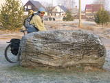 |
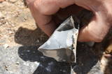
It lies between Pīlādžu street and the left bank of the river Siliņupe. In the 3rd to 2nd millenium B.C., there was a fishermen and hunters' settlement in the place of which there is installed an informational commemorational stone (Sculptor O.Skarainis). The settlement near the river Siliņupe is the oldest known human settlement in the area of the Ķemeri National Park. There are found many artifacts: pottery fragments and arrow tips, flint and amber pieces, etc..It is possible that the adjacent residential area has been the place of a cemetery. A small portion of the finds is displayed at the Lapmežciems Museum, the other ones are located in the National History Museum of Latvia. |
|
