
| Нo | Название | Описание |
|---|---|---|
 |
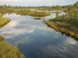
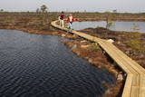
This was the first national park in Lithuania, and it is in the northern part of the Aukštaitija Higland, where hillocks interweave with lots of little lakes and ethnographic villages. Many of the lakes are connected with streams, forming long chains of lakes that are perfect for water tourists.
|
|
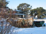 |
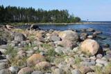
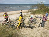
In the dunes of Lapmežciems, one still can find interesting historical monuments of fishermen life – ‘sedums’ – former fishing boat piers, where fishermen built their net huts and kept inventory. From here they went to the sea and came back, and, while fishnets where drying on the poles, men were discussed things. The ‘sedums’ of Lapmežciems is under the status of architectural heritage of local importance and is waiting for reconstruction. Today, there are three huts, well seen from the sea. If you look for the place coming by the main road, there is a landmark – a metal bull installed to advertise a local metal working company. The road passing it leads straight to the “sedums” and to the beach. In the nearby Ragaciems village, the local fishermen have reconstructed, with own labour and money, some old net huts in memory of their grandfathers. Reconstruction is still going on, and the already rebuilt net huts have been put in active use. Lapmežciems is also a promising bird watching site because here migrating birds are attracted by seaweed cast ashore. |
|
 |
Самый молодой национальный парк Латвии (2007 г.) находится в „Крае голубых озер” – в Латгальском крае. Одной из задач создания парка было сохранение самого полноводного Латвийского озера - Разнас, самого богатого островами озера – Эжезерс, и других водоемов, а также сохранение характерного для Латгалии холмистого пейзажа и культурно-исторической среды. В настоящее время одним из самых популярных объектов национального парка является Маконькалнс с прекрасным видом на озеро Разнас. В настоящее время в этом сравнительно молодом парке пока только планируется и производится его туристическое благоустройство - создание троп, маршрутов и т.д., поэтому желательно посещать уже законченные объекты. |
|
 |
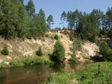
Vikmesti dēvē arī par Foreļstrautu, jo tā ir nozīmīga foreļu un taimiņu nārsta vieta. Gaujas labā krasta pieteka ir izveidojusi dziļu gravu ar stāvām nogāzēm, kuras lejtecē izveidojušies nelieli – ap 4 m augsti smilšakmens atsegumi. Gravas labajā (rietumu pusē) paceļas ar mežu apaugušais Vikmestes pilskalns. Gar Vikmestes upi izveidota taka, kuras sākumdaļa atrodas pie Siguldas – Turaidas ceļa, bet beigu daļa – pie Raganas – Turaidas ceļa (ap 3 km). |
|
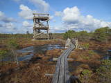 |
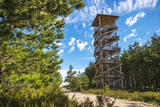
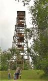
Atrodas 3,7 km garās laipu takas vidusdaļā. No torņa paveras viena no Latvijas izcilākajām augstā purva ezeriņu un lāmu kompleksa ainava. Tornis ir populāra saullēktu un ziemeļblāzmas fotografēšanas vieta. |
|
 |
The Ķemeri National Park was established in 1997 and mostly involves wetlands – the shallow shores of the Bay of Rīga, an overgrown seaside lake, vast swamps, damp forests and fens, and flood-land meadows. The park is enormously important for protecting plants (25% of those recorded in Latvia’s Red Book are found in the park) and animals, particularly nesting and migrating birds. The Great Ķemeri Bog is one of the largest swamps in Latvia, and there are other swamps, as well – the Zaļais swamp and the Raganu swamp. The massive swamps are important, too, in the flow of sulphuric waters and medicinal mud. The once-famous Ķemeri Spa was based on the availability of these resources. Most of the cultural and historical objects in the Ķemeri National Park relate to the seashore as a place for leisure and recuperation. Educational nature trails, bicycle trails, hiking trails, bird-watching towers and other facilities are available. The visitors centre is at the recently renovated “Forest House” in Ķemeri. |
|
 |
This territory is Lithuania’s most forested area, and people here have always lived in accordance with nature. Local treasures include berries, mushrooms, honey, clean water from streams and rivers, etc. People here have engaged in various crafts, as well as in beekeeping.
|
|
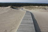 |
This is the only place in the Baltic States where there is such a vast territory of open-air sand dunes which still change the local terrain very actively because of the wind. The only Sea Museum and Dolphinarium in the Baltic States can be found here.
|
|
 |
Национальный парк Матсалу (48 610 га) создан для охраны гнездящихся, линяющих и пролетающих птиц. В 1976-ом году Матсалу был занесен в список Рамсара. Матсалу является международно значимым местом остановки различных водоплавающих и других перелетных птиц и становится все более популярным регионом для наблюдений за птицами во всей Европе. В Матсалу имеются многочисленные природные тропы и 8 вышек для наблюдений за птицами. |
|
 |
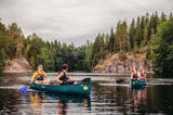
Национальный парк Соомаа был создан в 1993-ем году для защиты больших болот, заливных лугов и лесов. В гостевом центре парка можно познакомиться с информацией о туристских тропах Соомаа и других местных услугах, также познакомиться с постоянной экспозицией и медиа-программами. Здесь же начинается учебная тропа, которая знакомит с жизнью бобров. Соомаа известна своими наводнениями (март- апрель), это время называют пятым временем года. Во время высокой воды в Соомаа организуются путешествия по лесам, лугам и рекам на каноэ и лодках-долбленках (www.soomaa.com). Национальный парк Соомаа — единственное место в мире, где можно научиться древнему искусству создания лодки-долбленки и принять участие в практическом лагере. |
|
 |
Koka skatu tornis atrodas blakus Kolkasraga priežu takai. No tā redzama ar priedītēm aizaugusi „stiga” – t.s. Šautuve, kuru padomju laikā izmantoja šaušanas apmācībām. No torņa skatu platformas labi saskatāma Kolkas bāka, kas atrodas 5 km attālumā no Kolkasraga. |
|
 |
The national park was established to protect the 100 or so small islands that make up the archipelago of the local area. The largest island, the Vilsandi Island, is 6 km long and up to 2 km wide. You can rent a boat to get there, or, during appropriate conditions, you can walk across the sea and the small islands from the southern end of the Kuusnõmme peninsula.
|
|
 |
This park is located in the northern part of the Žemaitija Highlands, and much of it is taken up by Lake Plateliai. The park was established to protect lakes, rivers, wetlands and forest ecosystems, as well as the local cultural environment.
|
|
 |
This is the first national park in Estonia and the Baltic States. Perfect for a day trip out from Tallinn for a hiking trip and nature watching. It was established in 1971 to protect the area that is along the Bay of Finland – the shoreline, forests, swamps, meadow biotopes, species, natural monuments, rocks, waterfalls, cliffs and cultural monuments such as ancient cemeteries, castle hills, baronial estates, fishing villages, etc. |
|
 |
Lielais Liepu kalns ir Latgales augstienes Rāznavas pauguraines augstākā un Latvijā trešā augstākā virsotne (289,3 m v.j.l.). Lielpaugura relatīvais augstums ir 86 m! Skatu torņa platforma ir šobrīd augstākais Latvijas punkts (323 m.v.j.l.), kas sasniedzams ar paša kājām! Liepu kalna apkārtne ir labiekārtota. |
|
 |
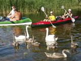
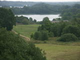
The Gauja National Park, established in 1973, was Latvia’s first national park, and it has a wealth of tradition in environmental protection and tourism. Indeed, the GNP is one of the most popular tourist destinations in Latvia. The main “artery” of the park is the ancient Gauja River valley, which was left behind when Ice Age glaciers receded. The valley is 95 kilometres long, with many tributaries that are also in deep ravines with massive sandstone cliffs from the Devonian period. The deepest part of the river valley is at Sigulda, where it is 85 metres deep. The territory has a great diversity of species – some 900 plant species in all. The Gauja is Latvia’s most popular river for water tourism, and many tourist accommodations are found along its shores. The Gauja National Park is one of the best-appointed protected territories in Latvia in terms of nature trails and tourism routes. Nature trails at Līgatne pass along paddocks of wild animals – the largest and most complete object of its kind in the Baltic States. The park also features cultural monuments of pan-Baltic importance – the Turaida Museum Reserve, the medieval old town of the city of Cēsis with its famous castle ruins and St John’s Church, the lake castle at Āraiši, etc. Visitors centres are found in Sigulda, along the Līgatne nature trails, and at the Zvārte rock. The administration of the GNP is building a new and modern visitors centre in Sigulda.
|
|
 |
Within easy reach of the Finnish capital of Helsinki, visitors can escape into wild natural settings and enjoy typically Finnish scenery, with lovely lakes, green forests and rugged crags. The nearby Finnish Nature Centre Haltia spotlights the best of Finland's natural treasures from across the country. |
|
.JPG?size=160) |
This park was established mostly to protect a wide range of cultural and historical objects such as the Trakai lake castle, the ancient Trakai cloister, the Užutrakai castle, the Bražole castle hill, the heritage of ancient local tribes, etc.
|
|
 |
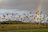
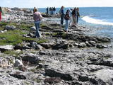
Слитерский национальный парк (как заповедник основан в 1923 г., как национальный парк 2000 г.) не без основания называют музеем под открытым небом предшествующей стадии развития Балтийского моря. Современными «живыми» свидетелями тех геологических событий являются Слитерские Голубые холмы - крутые, высотой до 20 – 30 м, образовавшиеся со времен Балтийского ледового озера (стадия Балтийского моря до 10 000 лет назад), холмы Стиебру – древний берег Анцилового озера (8 – 9 тысяч лет тому назад), наибольший в Европе по площади ландшафт валообразных дюн (кангари) и заболоченных междюновых впадин (виги), которые являются образованиями времен Литоринского озера (4 – 7 тысяч лет тому назад). Мягкий климат Северного Курземе служит причиной тому, что здесь наблюдается многообразие пород растений (около 860 пород) и встречается очень много редких для Латвии растений (напр., тис обыкновенный и плющ балтийский). Своего рода заслуга в сохранении здешних природных богатств принадлежит и советскому военному режиму, существовавшему когда-то на морском побережье, и из-за которого на протяжении полувека побережье оставалось почти нетронутым с точки зрения посещения и строительства. Свидетелями того времени остаются покинутые базы и разные военные объекты армии СССР. В Слитерском национальном парке находится один из популярнейших объектов туризма Латвии - Колкский мыс, который в течение года посещают более 50 000 путешествующих, а во время весенней миграции через мыс в течение часа проносятся десятки тысяч птиц. На участке берега Балтийского моря – т.е. на Либиешском берегу от Колки до Сикрага и Овиши сохранились рыбацкие поселки ливов (одна из малочисленных народностей мира) и прочие свидетельства их культуры. К услугам туристов четыре природных тропы, веломаршруты, наблюдательная вышка, открыт для посещения Шлитерский маяк.
|


