
| Нo | Название | Описание |
|---|---|---|
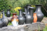 |
Обаятельный гончар приглашает в гости, предлагает экскурсию, демонстрацию навыков, участие посетителей в процессе производства керамических изделий, а также приглашает интересующихся на открытие печи. Приобретение гончарных изделий. |
|
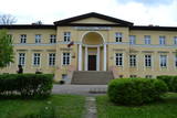 |
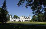
Tāšu – Padures muiža (Tasch – Paddern) celta 19. gs. sākumā kā Korfu dzimtas pils, kas 1852. gadā pāriet Keizerlingu dzimtas īpašumā kā medību pils, kas kalpojusi kā vasaras mītne, un ir izcils vēlīnā klasicisma paraugs. Iekštelpās saglabājušies vairāki senā interjera apdares fragmenti. Pēc pils pabeigšanas, ap to sāka veidot vairāk kā 10 ha lielu parku ar svešzemju kokiem. Šobrīd muižas ēkā atrodas Kalvenes pamatskola. |
|
 |
В избе проводятся занятия по отдыху и досугу для лиц разного возраста. Творческая мастерская и различные лекции рассчитаны на семьи, способствуют их творчеству. Для детей процесс запуска змея в небо становится ритуалом – дети запускают в небо свои мечты. Максимальное количество людей - 20. |
|
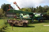 |
Единственное кафе в Латвии, имеющее достаточно непростой интерьер – военная техника и прочие атрибуты, в т.ч. Советской армии. В саду кафе тоже имеются интересные, заслуживающие внимания экспонаты – артиллерийские снаряды, самолет, военные автомашины и др. Действительно, стоит того, чтобы зайти и выпить чашечку кофе.
|
|
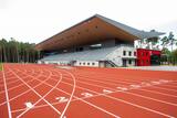 |
Изначально был открыт в 1938-м году, но позже многократно перестроен. Возле стадиона установлен памятный камень в честь Яниса Далиньша (1904 – 1978), который являлся многократным рекордсменом мира в спортивной ходьбе. В 1932-м году на Олимпийских играх в Лос-Анджелесе Я. Далиньш занял второе место в спортивной ходьбе. На стадионе в 1993-м году состоялись первые всемирные латышские Олимпийские игры Трех Звезд. В наши дни стадион Далиньша является легкоатлетическим стадионом государственного значения, на котором проходят международные соревнования, и местом для занятия спортом, получившем статус самого дружественного места для молодежи. |
|
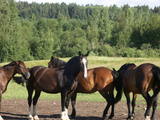 |
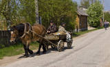
В «Унтуми» содержат и восстанавливают стадо лошадей, и покупают лошадей, которые исторически соответствуют требованиям породы коней, выведенной в Латвии. Здесь на ограниченной площади и на просторах можно научиться основам верховой езды в сопровождении инструктора. Летом предлагается катание в коляске, зимой - в подводе. Лошадей используют на свадьбах и на других торжественных мероприятиях. |
|
 |
В отреставрированном замке Алатскиви можно познакомиться с жизнью и историей одной помещичьей семьи в экспозиции, которая проходит через три этажа. Гиды замка расскажут различные истории и легенды, можно изготовить свой личный замковый сувенир. Сказочный замок у восточной границы Эстонии ждет своих гостей! |
|
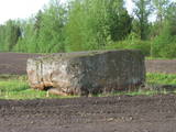 |
Rīgas - Daugavpils šosejas (A 6) 157. kilometrā skats jāpavērš Daugavas (rietumu) virzienā, kur cauri koku alejai klajā laukā 50 m attālumā no ceļa iegūlis Vaiķu akmens (7 m garš, 4,7 m plats un 1,7 m augsts). Akmens, kura tilpumu vērtē ~ 45 m³, pēc formas atgādina plakanu galdu. Nostāsti vēsta, ka to šeit atnesis velns. Kā jau šādiem akmeņiem „pienākas”, stāsta, ka te pusdienojis gan Krievijas cars Pēteris I, gan pats Napoleons. |
|
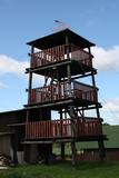 |
This is an interesting viewing tower which is part of one of the farm buildings. It offers a lovely view of the surrounding area.
|
|
 |
Farm is located ~1 km to the north of Puikule near to the former Limbazi railway, in the territory of North Vidzeme Biosphere Reserve. The farm breeds sheep of the Latvian dark-head breed from which wool, hats, scarves, souvenirs etc. are made by felting. They can be purchased in the farm. Sheep graze in nearby meadows, thus promoting plant diversity in the area. About the role of pets in maintaining biodiversity can also be read on the bench in the yard. In the barn house is a collection of household items. Visitors can take a guided tour and buy souvenirs. |
|
 |
В хозяйстве «Стуриши» семейства Тайзели можно заказать ливские блюда: ливский рыбный суп, кашу из ячменя, бутерброды с килькой, пироги и т.д. |
|
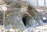 |
Руины замка Хельме возвышаются на крутом склоне у шоссе Пярну- Валга. На протяжении веков замком владели немцы, русские, литовцы и шведы, которые и уничтожили замок в 1658-ом году. Под горой в овраге журчит родник Арстиалликас, вода которого считается лекарством от семи болезней. К северу от развалин крепости находятся пещеры Хельме, которые в старину назывались Адом, основной достопримечательностью которых являются два зала. Еще в поселке расположен Краеведческий музей Хельме. |
|
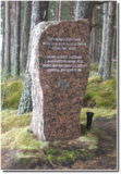 |
Место памяти борьбы финских
егерей в Клапкалнциемсе. Место, где
захоронены пять павших финских солдат во
время Первой мировой войны. В мае 2004
года установили по новой первичный,
установленный в 1929 году и снесенный в
Советское время памятник. В
Лапмежциемском музее можно посмотреть
фотографии и получить более подробную
информацию о финских егерях.
|
|
 |
В XV столетии господская усадьба Прейли становится родовым имением графов Борхов. Борхи хозяйствовали здесь до 60-х годов XIX века. Сам город образовался в первой половине XIX века при сливании имения Прейли с селением и слободой - поселением ремесленников и торговцев. В XIX веке в Прейли построили роскошный дворец и разбили ландшафтный парк. Современный город Прейли – это важный экономический центр Латгалии (сырное и швейное производство), который бережно относится к своему фольклору, традициям ремесленничества и католицизма. По Прейли настоятельно рекомендуется экскурсия в сопровождении сотрудника ИЦТ Ирены Кяркужи. |
|
 |
Во вторую субботу каждого месяца в Балви собираются крестьяне, надомники и ремесленники, чтобы предложить свою произведенную продукцию. Здесь каждый найдет что-нибудь вкусное или какую-нибудь полезную вещь. |
|
 |
В 17-18 веках на западный берег Чудского озера пришли бежавшие от гонений в России старообрядцы, для которых была характерна жизнь в длинных, километровых деревнях-улицах. Вдоль побережья Чудского озера располагаются деревни Касепя, Тихеда, Кюкита и Рая - 8-ми километровая полоса длинных деревень тянется до Муствеэ и является одним из немногих мест в Эстонии, где живут старообрядцы. Деревня - улица с уникальными молельными домами и культурным наследием старообрядцев - это прекрасный туристический объект,который подарит Вам много интересных моментов. |
|
 |
Группам гурманов хозяйка предлагает поучаствовать в различных кулинарных мастерских (2- 3 урока): в «Мастерской сладкой сдобы», «Мастерской сезонных нетрадиционных овощных блюд», «Мастерской пицц», «Приготовление конопляного стака (масла)» и др. Для тех, кто сам не хочет готовить, предлагается неторопливое деревенское угощение с осмотром хозяйства, виноградного сада и рассказами о жизни в деревне. |
|
 |
This park was set up to protect the lovely ancient valley of the Dubysa River. This is one of the most popular rivers for water tourism in Lithuania, because it has a significant drop with rapids and beautiful shorelines.
|
|
 1 день
|
Kihnu Island is the largest island in the Gulf of Rīga and the seventh largest island in Estonia. Its total area is 16.9 km², the island is 7 km long and up to 3.3 km wide. The former seal hunter and fishermen’s island, with around 600 inhabitants, is currently eager to maintain its identity in spite of everything. The unique characteristics of the Kihnu cultural space, like the lifestyle of the community, the diverse cultural traditions, the Kihnu language, music, national costumes and nature, are included in the UNESCO cultural heritage list. A coastal route that goes through four villages – Sääre, Linaküla, Rootsiküla and Lemsi - will help you to discover the cultural and natural values of Kihnu Island. You can visit Kihnu Museum all year round and get insight into the history of the island, including the life of the famous local captain, Kihnu Jõnn. It is also worth seeing Kihnu Church and the cemetery located across from the museum. In the summer, you can enjoy a beautiful view of the island, the surrounding sandbanks and the sea from the lighthouse. The commemorative stone by the former house of Kihnu Jõnn introduces you to the island’s legendary “wild captain”. |
|
 |
This restricted area protects the highest hillock in the Alūksne highlands – Dēliņkalns Hill – as well as the biotopes on its hillsides. The local landscape is also protected. Downhill ski trails are on the mountain, and its southern side offers lovely views.
|
|


