
| Нo | Название | Описание |
|---|---|---|
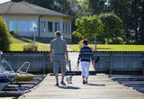 |
Отель расположен недалеко от моря в тихом месте, всего в нескольких минутах ходьбы от центра Экенеса в Расеборге. Рядом находятся рестораны, магазины, железнодорожный вокзал и пляжи. |
|
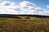 |
No ģeogrāfiskā un kultūrvēsturiskā viedokļa interesanta teritorija Latgales augstienes Rāznavas paugurainē, kuras nozīmīgākie resursi ir dažāda veida biotopi, ainavas, reljefs un Šķaunes ezers. Istras pauguraines dabas parkā nav ar tūrismu saistīti labiekārtojumi, bet šo teritoriju var apskatīt arī „no malas”, braucot pa grantēto ceļu no Soboļinas uz Osinovku, kas iet līdztekus parka ziemeļu robežai (skats uz Šķaunes ezeru).
|
|
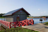 |
In the recreation complex it is possible to fish in the carp pond, as well as to swim and sunbathe on the landscaped beach on the loungers. There is a playground for children. It is also possible to organize banquets, seminars and other events. There is also a sauna with a fireplace hall for relaxation for up to 20 people. There are four campsites for accommodation, located above the water on piles. All cottages are heated, with separate shower and toilet, TV and wi-fi internet. Two of them have a kitchen, and one has a fireplace. Each cottage has three or four beds. Tents and camper sites are also available, and tents can be rented on site. |
|
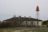 |
В советское время все маяки имели статус военных объектов, в том числе и маяк в Папе. В настоящее время маяк поддерживает Латвийская морская администрация, а осмотреть маяк можно только со стороны.
|
|
 |
Saimniecība nodarbojas ar tīršķirnes trušu audzēšanu, papildus tam audzē arī dažādu šķirņu mājputnus. Saimniecībā var apskatīt trušus, mājputnus, eksotiskos putnus, murkšķus, aitas, kazas, pudurkzas un punduraitas. Visi dzīvnieki izvietoti divos norobežotos voljēros, kur nesteidzīgi var apskatīt dzīvniekus, uzdot interesējošos jautājumus saimniekam. Pēc pastaigas ir iespēja sarūpēt sev maltīti ugunskura vietā un atpūsties lapenē. |
|
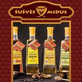 |
Организуются ознакомительные дегустации мидуса и мёда. Здесь можно приобрести разные продукты пчеловодства, свечи из натурального воска, мидус нескольких сортов. |
|
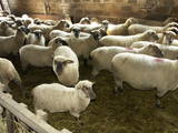 |
На просторных лугах хозяйства по берегам реки Айвиексте пасется крупнейшее в Латвии стадо Латвийских темноголовых овец (~ 400 животных). Осмотр хозяйства, приобретение породистых овец, мяса, шерсти, кожи и овощей. |
|
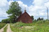 |
Моленная Римшской старообрядческой общины.
Церковь была построена в начале 20 века
|
|
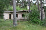 |
В настоящее время объект заброшен и не используется. Основная часть погранохраны находилась в лесу, примерно на расстоянии 0,6 км от моря. Одно здание находится непосредственно на берегу моря.
|
|
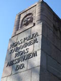 |
Поросшая соснами дюна, на которой находится памятник воинам 6-го Рижского пехотного полка – защитникам Риги в 1919 году. Здесь воины полка вели тяжелые бои против превышавшей по численности армии бермонтовцев и продолжили освобождение Риги и Пардаугавы. Центральный элемент памятника, созданного скульптором Карлисом Зале (обращен в сторону улицы Слокас), представляет собой стену высотой 12 метров с изображением головы льва в воротах Риги. По бокам стены расположены барельефы, изображающие древних латышских воинов и латвийских воинов в обмундировании 1919 года. На вершине дюны находится площадь с алтарем, чаша для огня и памятная табличка с именами павших воинов. Памятник в 1937-м году был открыт президентом Латвии Карлисом Улманисом. |
|
 |
Zemnieku saimniecība "Sprogas" ir Tīcu ģimenes dārzkopības uzņēmums, kura saknes veidojušās 90-to gadu sākumā, bet strauju attīstību tas ieguvis pēdējo desmit gadu laikā. Jau iepriekš "Sprogās" saimniekots ar vērienu – audzētas zemenes, narcises, lefkojas. Saimniecības vadītājs Ivars Tīcs darbošanās prieku dārzniecības jomā mantojis vairākās paaudzēs. "Sprogas" nodarbojas ar vasaras puķu stādu, augļu koku, dekoratīvo stādu, augļu un ogu audzēšanu. |
|
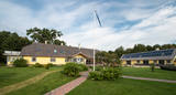 |
Nurka Farm is located in Luitemaa Nature Protection Area in Pärnu County. The farm complex that is over 100 years old has been renovated into a contemporary holiday farm with all modern conveniences. |
|
 1 день
|
This section of the Baltic Coastal Hiking Route is a comparatively short hike across a beautiful sandy beach, the coastal side of which is bounded by brightly colored pine forests with spectacular dunes and dams of dunes. To get from the beach to Carnikava, the Baltic Coastal Hiking Route will take you through a forest via a promenade. Then it takes a stroll around the Old Gauja River via a levee and reaches the pedestrian bridge over the Gauja River. Both as you start and end the hike, it is nice to sit in one of the pubs and summer cafés located on Vecāķi beach and in Carnikava. |
|
 |
The restricted area was set up to protect Nesaule Hill, which is a forested hillock in the area and features boreal and damp forests.
|
|
|
|
Die nach dem Bau der Straße Tallinn – Narva gefundene und rekonstruierte 36 alte Bestattungen (8. – 7. Jh. vor Christus) ist ein interessantes archiologisches Denkmal mit einem Besucherzentrum und einer geschichtlichen Ausstellung. |
|
 |
This is a segment of the Gauja River which is full of rapids in some places. It stretches from Vidaga and the place where the Vecpalsa River flows into the Gauja. Along the Gauja and its tributaries, dolomite outcrops can be seen on the shores, and the largest of these are the Randati cliffs. The restricted area was established mostly to protect various kinds of forests, meadows, outcrops and their habitats. This is an interesting part of the central section of the Gauja for people who enjoy beautiful landscapes and for those who are water tourists.
|
|
 1 день
|
Dodieties ekskursijā, lai gūtu ieskatu lauku profesijā un dzīvesveidā, kā arī iegūtu jaunus iespaidus un labu atpūtu visai klasei. Ekskursijas laikā apskatiet līdz 16 m augsto stāvkrastu ar gana iespaidīgiem skatiem. Pēc tam apmeklējiet lauku maizes ceptuvi, kur iespējams izveidot un izcept pašiem savu kukulīti. Ekskursijas noslēgumā dodieties uz pili, kas pazīstama ar stāstiem par spokiem, par rūķīšu kāzām un citiem nostāstiem. Pils parkā apskatāma Mīlestības aleja un Rūķīšu ozola vieta. |
|
 |
Местное предприятие, производящее прекрасную рыбную кулинарную продукцию. Благодаря широкому и качественному ассортименту предприятие завоевало стабильное место на латвийском рынке. Предприятие предлагает более 50 различных видов рыбной кулинарии – маринованную рыбу, рыбу в желе, рыбные салаты, а также мороженую рыбу и филе. (Источник: Ройский ТИЦ) |
|
|
|
Atrodas Ostas ielas rietumu galā. No laukakmeņiem veltīto kompozīciju uzstādīja 1938. g. (idejas autors – bijušais Ventspils ostas kapteinis V. Ābelnieks) un tā ir piemiņa visiem zvejniekiem un jūrniekiem, kuriem atdusas vieta ir jūras dzelme. |
|
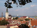 |
The capital of Estonia. The Old Town of Tallinn - excellent medieval (14.-15th century) building monument. The former city of Hanza. |
|


