
| Нo | Название | Описание |
|---|---|---|
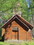 |
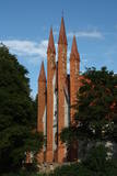
Моленная Крупенишкской старообрядческой общины построена в
1908 году. Автор проекта храма инженер И. Иванов. В теперешнее время
храм в плохом техническом состоянии.
|
|
 3 дня
|
Šis ir viens no 6 ceļojuma maršrutiem sērijā "Baudi laukus!", un tas aicina apmeklēt Lauku Labumus – visdažādāko veidu un nozaru saimniecības un uzņēmumus, kas atvērti apmeklētājiem, piedāvā ekskursijas, nogaršot, apskatīt un iegādāties savus ražojumus. Tur apskatāmi mājdzīvnieki, mūsdienīgas lauku saimniecības, amatnieku darbnīcas, iegādājami lauku produkti – maize, medus, mājas vīns un alus, siers, ogas, augļi, zivis, gaļa, dārzeņi, tējas un citi laukos audzēti labumi. Pa ceļam iespējams ieturēt pusdienas lauku krodziņos. |
|
 |
На Наукшенской винодельне с 2012 году делают вино, сидр и игристые вина. Фрукты и ягоды выращивают тут же, в Наукшенах, в биологическом сертифицированном саду ‒ Райском яблоневом саду. Предлагается экскурсия на производство и дегустация. |
|
 5 дней
|
Знаменитый курземский герцог Екаб правил в Курземе и Земгале ровно 40 лет (1642 – 1682). Во время его правления происходят большие изменения – быстрыми темпами развивается кораблестроение, появляются первые мануфактуры и повышаются объемы сельскохозяйственного производства. |
|
 |
Хозяйство Uibo предлагает посетителям традиционные блюда эстонской кухни, приготовленные из свежей свинины с минимальным количеством консервантов и добавок. |
|
 |
This is a territory that is unique at the Latvian and the Baltic level, one which stretches from Valmiera to the Gulbene District. Here we find the irregular Gauja River valley with a dense system of ancient rivers. The meadows on the banks of these rivers are important in terms of biological diversity. There are stands of oak and broad-leaf trees. Many rare and protected birds live and next here – the corn-crake, the woodpecker, etc. The territory is excellent for bird watching, nature studies, ecological tourism and various kinds of active tourism. |
|
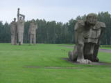 |
Находится между Румбулой и Саласпилсом и создан в том месте, где во время Второй мировой войны находился концентрационный лагерь немецких нацистов. В лагере уничтожено > 50 000 жителей оккупированных стран Европы. Мемориал памяти жертв тоталитаризма, который является одним из самых больших в Европе (25 га), был открыт в 1967 году. Мемориал образуют отдельные скульптуры и скульптурные группы. В стене входных ворот мемориала создана тематическая экспозиция. |
|
 |
Der Turm war der Eckturm der mittelalterlichen Stadtmauer von Pärnu. Der Turmhof ist ein beliebter Ort für Kunsthandwerkermärkte und ein Veranstaltungsort. |
|
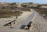 |
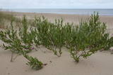
Die Dünen nördlich Pervalka über dem ehemaligen Dorf Negeln. Eine 9 km lange Strecke mit den wüstenartigen Landschaften. Stegpfade. |
|
 |
Дом ремесел Heltermaa ‒ это магазин произведенных в Хийумаа продуктов и изделий рукоделия. Магазин открыт в летний сезон. Выбор очень широк, начиная с керамической посуды и заканчивая лимонадами производства Хийумаа. |
|
 |
Traķu pirmsākumi ir meklējami Senajos Traķos, kas atrodas 4 km dienvidaustrumos no Traķu centra. Uzskata, ka Senos Traķus ir dibinājis Lietuvas dižkunigaitis Ģedimins (~ 1275. – 1341.) 14. gs. pirmajā pusē. 14. gs. otrajā pusē šeit uzcēla mūra pili, no kuras līdz mūsdienām ir saglabājušies tikai nostāvināti zemes vaļņi. Laikā no 1345. – 1382. g. tajā valdīja Ģedimina dēls – Ķēstutis (1297. – 1382.). Senajos Traķos dzimis arī viens no izcilākajiem viduslaiku Lietuvas valdniekiem – Ķēstuta dēls - Vītauts Dižais. Kā pilij, tā arī tās valdniekiem bija nozīmīga loma sekojošajos krusta karos un cīņās. 1391. g. pils tika sagrauta cīņas laikā ar Vācu ordeni, kādēļ arī zaudēja savu stratēģisko nozīmi. 1405. g. benediktīniešu mūki šajā vietā uzcēla baznīcu, bet 18. gs. beigās - jaunu un lielāka apjoma klosteri, kura vienu no korpusiem 1889. g. pārbūvēja par baznīcu. |
|
|
|
Metāla tornis Kazari upes kreisajā krastā, ~ 5 km attālumā no Matsalu līča. No torņa redzamās Kazari deltas palieņu pļavas atrodas tikai 0,3 – 1 m augstumā virs jūras līmeņa, tādēļ pavasara palos un stipru vētru (īpaši rietumvēju) laikā ūdens appludina milzīgu teritoriju. Uzskata, ka platības ziņā šīs ir vienas no lielākajām Eiropas palieņu pļavām, kas ir nozīmīga dažādu tārtiņveidīgo putnu sugu ligzdošanas, dzērvju un zosveidīgo putnu atpūtas un barošanās vieta. Ir pagājis laiks, kad zemnieki Matsalu pļavās ganīja govis un pļāva sienu, tādēļ šobrīd pļavu apsaimniekošanu veic nacionālā parka administrācija. |
|
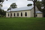 |
Jau pēc dievnama veidola var spriest, ka vēl ne tik sen – padomju laikos ēka bija izmantota citām vajadzībām. Pēc 2. pasaules kara to atsavināja draudzei, bet torni – uzspridzināja, dievnamā ierīkojot noliktavu. 20. gs. deviņdesmitajos gados draudze uzsāka baznīcas atjaunotni un tagad tā kalpo savam pamatmērķim. |
|
 |
Расположен на территории Даугмале, которую омывают воды Даугавы. Благодаря этому пчелы могут собрать и принести высококачественный мед, который неоднократно завоевывал признание на латвийских конкурсах, а также другие продукты пчеловодства. |
|
 |
Хозяин – банщик, травовед, массажист, мастер Рейки – интересуется этнокультурой и предлагает гостям прадедами проверенные способы настоящего отдыха и укрепления здоровья – банные эдукации, секреты травоведения, восстановление связи с природой, водные процедуры. |
|
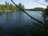 |
Dabas parks, kura lielāko daļu aizņem neprastās formas un līčiem bagātais Cārmaņa (arī Cārmins) ezers. Ezera ūdens ir ļoti tīrs, tādēļ tajā sastopamas Latvijai retas augu sabiedrības. Tā kā parka teritorijā nav tūristiem veidota infrastruktūra, interesenti var baudīt skatus, kas paveras uz ezera un tā apkārtni no Aulejas – Grāveru ceļa.
|
|
 |
В этом хозяйстве на острове Кихну предлагаются традиционные для Кихну блюда, приготовленные из выращенных в хозяйстве овощей и собственноручно пойманной рыбы. |
|
 |
The territory is established in order to protect the dunes and the seashore habitats. There are beautiful beaches and wooded dunes, and the paved Klaipēda–Palanga bikeway trails through the park, which is worth travelling at full length. |
|
 |
Natural flood-land meadows along the banks of the Lielupe before Jelgava. Many protected plants are found here, and birds nest and rest here during migration season.
|
|
 12 дней
|
Этот тур предлагает вниманию туристов различные пейзажи, местные обычаи и традиции, а также исторические достопримечательности. Обычно путешественников удивляет обилие контрастов на такой маленькой территории. Рига предлагает средневековый Старый Город и элегантный район Югендстиля, затем идет Сигулда с ее тремя замками на высоких берегах долины реки Гауя. Остров Сааремаа – удовольствие для поездок, с его качественными, тихими автодорогами, ветряными мельницами, средневековыми церквями и этнографическими деревнями. У Таллинна свой Старый Город, обнесенный стеной, в то время как Национальный парк Лахемаа предлагает практически мистические пейзажи. Здесь найдете и элегантное поместье Палмсе. Маршрут проходит по сонным деревушкам восточной Латвии с отличительными традициями гончарного мастерства, старинной кухни, и через место, привлекающее католических паломников – Аглону. Исторический центр Вильнюса славится своими церквями в стиле барокко. Массивные песчаные дюны Куршской косы и Нида с ее отличительными окнами с синими рамами – одни из наиболее выдающихся литовских достопримечательностей. В Тракай на озере расположен живописный средневековый замок, а также небольшое этническое поселение Карайтис с его уникальными традициями и кухней. Портовые города Клайпеда и Лиепая оба развились в шумные современные города с оживленной культурой городских кафе. |
|


