
| Nr | Name | Beschreibung |
|---|---|---|
 |
Saimniecība specializējas kazas piena produktu apstrādē, pieejami dažāda veida svaigie sieri, piens, kefīrs, biezpiens, fetas siers, krēmsiers. |
|
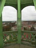 |
Der Bau der Kirche wurde 1283 angefangen. In der Kirche befinden sich die Grabsteine der angesehenen Bürger aus den 15. – 16. Jh., Orgel (1886), Kanzel und Chormalerei (1730). Blick vom Turm auf die Stadt. |
|
 |
The Buse (Matkule) castle hill is near the Imula River. From the castle hill and from the opposite shore of the river, you can find one of the loveliest views of Kurzeme’s small rivers. Their appearance is best when trees and other flora are bare and the view is unimpeded. A wonderful view of the Imula valley is also seen on the road to the castle hill – near the Buse homestead.
|
|
 |
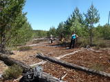
Der Vilce Naturpark ist klein und verläuft entlang der tiefen Tälern des Vilce - Flusses und seinen Nebenflüssen. Die Biotope umfassen Sandsteinklippen, Stromschnellen, Wälder, die für solche Gegenden typisch sind und die entsprechenden Pflanzen und Tiere darin. Der gut hergerichtete Burgberg von Vilce liegt neben der Zaķu-Wiese, die ein hübsch gestalteter und beliebter Platz zum Ausruhen ist.
|
|
 |
Reta galda vīnogu kolekcija un degustācija, ainaviska dārza apskate un stāstījums par ķirbjaugu, čilli un tomātu šķirņu kolekciju. Kolekcijā ir 120 šķirņu tomātu, 20 šķirņu paprikas un aso piparu, 140 šķirņu ķirbjaugu. Degustācijas galds - sukādes, čilli, interesanti ievārījumi un pašu fermentētas tējas. |
|
 |
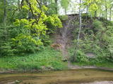
An den Uferhängen residieren das ganze Jahr über wilde Kühe. Über etwa 200 Stufen kann man zum Ufer des Flusstales hinuntersteigen, von dort hat man einen herrlichen Ausblick. Es empfiehlt sich, den Abstieg in Begleitung eines örtlichen Führers vorzunehmen. |
|
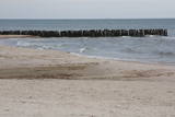 |
Die Meeresenge von Irbe ist sehr wichtig während der Vogelmigration. Von den geschützten Vogelarten begegnet man hier am meisten der Samtente, der Trauerente, der Eisente, der Zwergmöwe, dem Sterntaucher und dem Prachttaucher, sowie auch der Teiste. Das Gebiet befindet sich gegenüber der Regionen Dundaga und Ventspils. Die Fläche beträgt 172 412 ha.
|
|
 |
Das Bažu Moor – ist das größte Moor im Nationalpark Slītere. Es befindet sich
in der strengen Zone vom Naturverbot und ist für Besucher gesperrt.
|
|
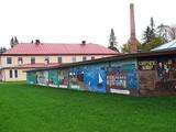 |
Die Entwicklung des Molkereiwesens in Estland begann in der zweiten Hälfte des 19. Jahrhunderts. Um die Geschichte des Molkereiwesens für nachkommende Generationen zu verewigen, wurde 1976 in Imavere das Estnische Molkereimuseum gegründet. Es gibt eine ständige Ausstellung und eine Exposition im Draussen. Unterschiedliche Museumsprogramme werden angeboten und sind gefragt. Für die Gruppen besteht die Möglichkeit eine Führung zu bestellen. Das estnische Molkereimuseum erzählt über die Herstellung von Milchprodukten zu Hause, hier sind Ausstellungen über die Geschichte der Milchwirtschaft anzusehen. Das Museum veranstaltet auch Workshops zur Herstellung von Süßquark, Käse, Eis und Butter. |
|
|
|
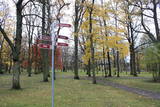
33,5 m augstais tornis tikai nedaudz paceļas virs priežu galotnēm. Tas meklējams Dzintaru mežaparkā, kas ir ģimenēm ar bērniem draudzīga vieta. No torņa redzami Jūrmalas meži, augstākās ēkas (sanatorijas, viesnīcas) un Rīgas jūras līča ūdeņi. |
|
 |
In mid-summer, the farm features the beautiful blooms of rapeseed and flax. A special facility for pressing rapeseed and flax seed oil is on site. You can watch the oil pressing process and purchase some of the resulting oil.
|
|
 |
Хозяйство занимается разведением кроликов и предлагает сортовую крольчатину, кроличьи шкурки и изделия из них. Ключ к успеху ‒ качественный корм, ветеринарный уход и хорошие условия содержания кроликов. |
|
 |
Meistardarbnīcā „Cimdiņi” darbojas Latvijas Amatniecības kameras diplomētā meistare Ina Valtere, pie kuras ikvienam ir iespēja uzzināt visu interesējošo par rokdarbiem, kā arī iegūt padomu un ieteikumus adīšanā, izšūšanā un tamborēšanā. Tiek piedāvāta iespēja piedalīties arī darbnīcās un meistarklasēs. |
|
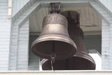 |
Находится в южной части города, на улице Синицина, 4. Храм построен в 1895 г., а в 1906 г. перестроен. На колокольне находится три литых из серебра и меди колокола (отреставрированные), один из которых является самым тяжелым в странах Балтии ( вес 4832 кг, язык колокола весит 200 кг)! Рядом расположен музей, который знакомит с культурной средой старообрядцев и церковной жизнью. |
|
 |
Братское кладбище Лачукрога –
кладбище павших во время Первой мировой
войны.
|
|
 |
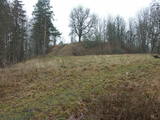
Sens pilskalns Abavas kreisā senkrasta nogāzē. Pēc sena nostāsta zviedru karavīri ar savām cepurēm to sabēruši virs sava ģenerāļa kapa. Tagad Zviedru cepures apkārtnē ziemā var braukt pa kalnu slēpošanas trasēm, bet vasarā – ar rodeļiem.
|
|
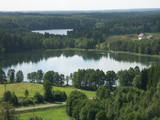 |
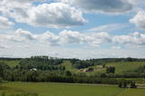
This territory is rich with forestland and lakes (some 285 in all). There are extensive opportunities for active recreation or calm leisure.
|
|
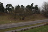 |
Место, где согласно доступной информации находилась лаборатория по испытанию авиационных двигателей, предназначенных для военных целей. В наше время свидетельств тому нет, так как это индустриальная и недоступная территория.
|
|
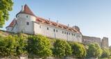 |
Одна из важнейших опорных точек Ливонского ордена, замок построен в 1443 - 1456 гг. в месте слияния двух рек – Мусы и Мемеле. В наши дни замок возродился в новом облике - здесь создан современный музей, а в юго-восточной башне – смотровое место / площадка. |
|
 |
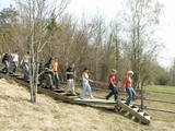
Viens no lielākajiem cilvēka veidotajiem Latvijasparkiem (70 ha), kas izstiepies no Liepājas ostas līdz Dienvidu fortam > 3 km garumā. Tā izveidi uzsāka jau 1870. g. pēc pilsētas mēra K. Ūliha iniciatīvas, uzbūvējot kūrmāju un strūklaku. 19. - 20. gs. mijā ap Dzintaru un Liepu ielām parādījās greznu villu un savrupmāju apbūve. Viena no skaistākajām ir jūgendstilā celtā savrupmāja Liepu ielā 27, kurā atrodas Krievijas ģenerālkonsultāts. Ēkai ir slēgta uzeja, balkoni, pildrežģa konstrukcijas un kārniņu jumts (arhitekti G. Jenike un P. M. Berči). Jūrmalas parks visās sezonās ir iecienīta pastaigu un dažādu aktivitāšu norises vieta. Te meklējams stadions „Daugava”, tenisa korti, koncertestrāde “Pūt, vējiņi!”, vasaras kafejnīcas, minigolfa laukums, bērnu rotaļu laukums, skeitparks. Šeit meklējamas lielākās Latvijas bungas – vides dizaina objekts. |
|


