
| Нo | Название | Описание |
|---|---|---|
 2 дня
|
Маршрут подходит для водных туристов, которым не нравится однообразие. Латгальские озера до сих пор остаются территорией, мало освоенной водными туристами, но очень привлекательной с точки зрения как ландшафтов, так и культурной среды. Информация о маршруте от Latvijas Lauku forums |
|
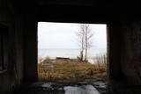 |
Окинув сегодняшним взором, кажется невероятным, что какие-то двадцать лет тому назад на побережье располагались специально построенные сооружения с мощнейшими прожекторами, которые в темное время суток по специальным рельсам выталкивались на платформах с целью освещения близлежащей морской акватории и пляжа в поисках потенциальных нарушителей границы. От упомянутого объекта сохранились только развалины сооружений и прилегающей платформы, над которыми здорово потрудились волны моря.
|
|
 |
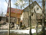
«Стиканы» находится в 2 км от Нагали, на самом берегу Оренишских прудов. Гостевой дом имеет 4 комфортабельных двухместных номера и столовую с выходом на садовую терассу. На территории дома оборудована природная тропа, прогуливаясь по которой в сопровождении знающего гида, вы можете ознакомиться с типичными для Латвии деревьями и кустарниками, популярными и менее известными лекарственными растениями и большей частью гнездящихся у нас летом птиц, или понаблюдать за впечатляющей миграцией птиц весной и осенью. |
|
 |
The Sunset trail starts in the centre of Saulkrasti town and takes you to the White Dune. Saulkrasti town with its municipal rural territory, occupies a 17km long stretch of coastal land to the North from the river Lilaste and the lake Lilaste. The White Dune stands on the right side of river Inčupe mouth. It is covered by old pine forest. The white, 18m high sand outcrop in olden times served as a landmark for fishermen. The White Dune formed as winds carried the sand from the beach over clay sediments of the Baltic Ice Lake. Some 150-200 years ago, the dune had been drifting as witnessed by several layers of soil buried within it. Local fishermen and farmers at Bātciems initiated afforestation of the drifting dunes. At that time, the 30m high dunes which are now covered with forest, were bare, shifting and even buried a farmstead. To speed up afforestation, mountain pines were planted. The White Dune was partly washed away in heavy storm in 1969, and 4-6m high precipice formed. Now the wind and sand have levelled out the dune surface, it has been fixed with willow-twigs or grown with forest where the largest pines are more than 170-190 years old. The pines are notable with their large trunks and branches, the scars obtained during their lifetime and the typical “crocodile skin” – the bark forms rhombuses resembling those of the reptile’s scales. Scots Pine (Pinus Silvestris) is one of the most common tree species in Latvia. It grows in dry, meagre sandy soil in dunes as well as in marsh. However, it does not stand overshadowing. Forest fires help pines to get rid of competitors as pine endures fire better than other trees because of its thick bark and high crown. The wood exudes resin and burned wounds close soon. Fire cleans space for seedlings of young pines. Pines can live 300-350 years. Ground cover in dune forests is very sensitive. If the sparse vegetation is destroyed, not only the natural biodiversity and landscape is damaged, but also the dangerous shifting dunes can possibly “wake up”. Embryonic dunes, White (yellow) dunes, Grey dunes and Wooded dunes are EU protected biotopes. Grey Dunes are protected by Latvian law as well. |
|
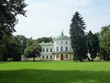 |
Усадьба Байсогала представляет собой одно из древнейших, так называемых королевских имений, поскольку некогда она принадлежала великому князю литовскому. До наших дней здесь сохранился нарядный дворец в стиле позднего классицизма (ампира), построенный в середине XIX в. Пейзажный парк усадьбы Байсогала площадью 12 га был заложен в первой половине XIX в. Со стороны поселка в сторону усадебного дворца ведет каштановая аллея. От ворот главная аллея проходит между двумя прудами причудливой формы, через мостик с фигурами львов. За дворцом простираются извилистые аллеи и узкие парковые дорожки, окруженные деревьями. По обеим сторонам главной аллеи парка вырыты пруды, а в глубине парка скрывается еще один пруд с островком. |
|
 |
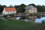
The Narūta River which flows out of Lake Ežezers is approximately 1 km long and ends at the small Obiteļi windmill lake. On the right bank of the river is a windmill that was built around 1900. Today the site has the Obiteļa leisure centre with a sauna and banquet facilities. |
|
 |
На крестьянском рынке Lõunakeskus продаются выращенные в Эстонии и приготовленные из местного сырья продукты ‒ и на каждый день, и к праздничному столу. Разнообразные продукты в основном поступают из хозяйств Южной Эстонии, но можно найти товары и из других регионов страны. Также работает уютное кафе, где можно отведать блюда, приготовленные из продающихся на рынке свежих продуктов. |
|
 |
Название Айнажи - неотъемлемая составная часть истории мореплавания Латвии. В 1864 г. здесь было основано первое мореходное училище, в котором могли учиться дети латышских крестьян. Закономерным является то, что Айнажи стал важным судостроительным и портовым центром побережья Латвии. Экономической жизни города способствовал и открытая в 1913 году узкоколейная железнодорожная линия Смилтене –Валмиера – Айнажи. Современный Айнажи - маленький и тихий городок Латвии, в приграничном районе с Эстонией, с несколькими интересными объектами для осмотра. |
|
 |
Место, где согласно доступной информации находилась лаборатория по испытанию авиационных двигателей, предназначенных для военных целей. В наше время свидетельств тому нет, так как это индустриальная и недоступная территория.
|
|
 |
This is not a well known castle hill, but it offers one of the most unusual views of Lake Lielezers of Augstroze. There are ruins on the castle hill, and a short hiking trail has been installed to look at them. This is part of the ZBR.
|
|
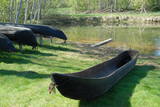 |
В парке «Виенкочу» можно увидеть созданные мастером предметы из деревянных колод, осмотреть макеты Нурмижского замка и других зданий, дом Песка, а также поучаствовать в тематических мероприятиях. Мужчины могут изготовить желобки для березового сока, а женщины – украшения из натуральных материалов. Предметы из колод древние люди изготавливали еще в мезолите, а челночные лодки (в парке их несколько) начали широко использовать с IX столетия. |
|
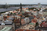 |
St Peter’s is one of the oldest historical monuments in the Baltic States, and it is also the best place from which to survey the historical centre of Rīga, which is part of the UNESCO list of world cultural heritage. You can see the central part of Old Rīga, City Hall Square, the Pārdaugava region on the opposite side of the river, and even – during clear weather – the Bay of Rīga. The tower of the church is 123 metres high, but the viewing location is at a height of 72 metres.
|
|
 |
No Vilsandi bākas un tai tuvākās apkaimes ir labi saskatāmas leģendārās Vaikas salas. Tām ir piešķirts rezervāta statuss, tādēļ salas var apskatīt tikai no attāluma. Mazākā no saliņām - Kullipank ir tikai pārdesmit metrus diametrā. Tā ir jūras ūdeņu izrobots zemas un asas dolomīta klints fragments, kas klāts ar oļiem, nelieliem laukakmeņiem un kādu atsevišķi stāvošu lakstaugu. Domājams, ka vētru laikā tā pazūd zem jūras ūdens. Savukārt, Alumine Vaigas – Apakšējā Vaikas sala ir lielākā no sešām salām. Šīs salas diametrs ir ~ 150 m un tā paceļas vismaz kādus divus metrus virs jūras līmeņa. Uz salas ir bagātīga veģetācija un pat kāds zems krūms salas centrā. Redzami arī metru augsti atsegumi. Uz salas vēl joprojām atrodas 20. gs. sākumā celto „putnu māju” paliekas, kas bija domātas ligzdojošo putnu piesaistīšanai. |
|
 8 дней
|
Saaremaa and Hiumaa are the two largest ones amongst 1500 other Estonian islands. In fact Saaremaa is the common name for Muhu and Saaremaa islands which are connected by the causeway like Hiumaa and Kassari islands. |
|
 |
В 0,2 км к северо-востоку от Ливского народного дома, с дороги Мазирбе - Кошрагс виднеется «Сеппес». Хозяйственный амбар, имевший в углах бревенчатые соединения впритык, который в 20 - 30 годы прошлого столетия строил пришедший из Самсалы в Мазирбе эстонец - рыбак и плотник Екабс Яга. На другой стороне дороги виднеются «Калши» - жилое строение начала XX века. Восстановлено в наши дни, сохраняя в стенах дома кирпичи, которые обжигались в Брауской кирпичной печи Мазирбе. |
|
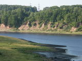 |
In Aizkraukle, drive down Enerģētiķu Street to the Selonian side (there will be small “pockets” at the side of the road) to see one of the best views of the Daugava River valley, reminding us of what this fateful river was like before the power plant was built. You will see that the river has eroded the steep cliffs on the right bank. The further part of the valley is part of the Daugava Nature Park.
|
|
 |
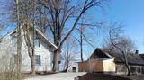
For the first time Vihula Manor is mentioned in 1501. The complex you can see now has been made after 1810. It was finished in 1880. Now here is an excellent hotel, SPA complex, a restaurant and more. Around the manor is a park. |
|
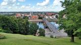 |
The second biggest city in Lithuania and from 1920 – 1939 - a temporary capital. The Old Town, The Town Hall (16th century), St. Peter and Pavil cathedral - basilica (15th century), Thunder building (15th century), Laisves alley, Ciurlionis Art and Devil Museum. |
|
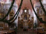 |
Одна из выдающихся католических церквей Латвии. Осматриваемый сегодня каменный храм построен в 1761 году в стиле польского барокко. Сохранился оригинальный и очень роскошный интерьер (XVIII в.). Ежегодно здесь проводятся мероприятия духовной музыки и дни польской культуры. В сопровождении гида можно осмотреть церковь и другие туристические объекты приграничного района ЕС (необходимо наличие паспорта!) |
|
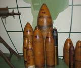 |
Музей располагается в Пороховой башне, которая в средние века в Риге была существенной составной частью городской системы фортификации. Основная тема музея – военно-политическая история Латвии и с этим связанные экспонаты.
|
|


