
| No | Name | Description |
|---|---|---|
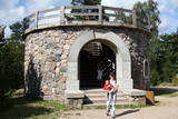 |
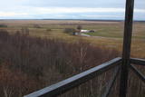
This arboretum park is in a lovely place – the Blue Hills of Ogre, where there is a tower with a good view of the Daugava River Valley. The landscape is enlivened by a pond and its streams. There are beautiful hiking trails throughout the park.
Unique species: The Amur Cork Tree (Phellodendron amurense) and the Field Elm (Ulmus minor), among others.
|
|
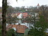 |
The town of Talsi is known as the “town of the nine hillocks,” and it is worth touring the location on foot. You’ll find the best views from the Talsi castle hill (views of Lake Talsi and Ķēniņkalns Hill), Sauleskalns (Lake Talsi, the castle hill, Ķēniņkalns Hill), and the hiking trails of Ķēniņkalns (Lake Talsi, the castle hill, the historical town centre).
|
|
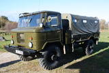 |
Edgars Kārklevalks, operator of a guesthouse Pūpoli, has a restored Soviet military GAZ-66 truck in which he offers historical and informational tours of Northern Kurzeme. The route includes former military territories.
|
|
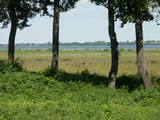 |
There are three large lakes at the centre of this park – Lake Dusia, Lake Metelys, and Lake Obelija. Lake Dusia has very clear and transparent water, and its southern and south-eastern beaches are popular among swimmers. The lakes and their nearby wetlands are important during the migration season of birds.
|
|
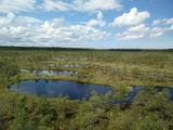 |
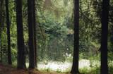
This is one of the largest high-type swamps (6,192 ha) in Latvia, with very distinct landscapes of little lakes and hillocks. The Great Ķemeri Heath is of importance as an extensive hydrological system and preserver of the local microclimate. It is also of international importance as a site for birds, as well as a major source of sulphurous water. Along the Kalnciems-Kūdra road, which is on the eastern edge of the swamp (3.4 km from the Rīga-Ventspils highway), there is an information stand with information about the management of the heath and about the role of swamps in nature and in the lives of people. Great Ķemeri Heath wooden pathway trail is now restored and opened for visitors in 2013. |
|
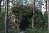 |
Der dritgrößte Feldstein im Baltikum (584 m3, 7 m hoch, Durchmesser bei dem Grund – 32 m ). Auf estnisch bedeutet „Hausstein”. Befindet sich am Rande des Pikanõmme – Majakivi Pfades (4,5 km lang). |
|
|
|
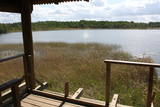
Uzcelts Kaņiera pilskalnā un ir Kaņiera pilskalna takas sastāvdaļa. No torņa paveras izcila Kaņiera ezera dienvidrietumu daļas ainava ar niedru saliņām un nelieliem atklāta ūdens laukumiem. Laba putnu vērošanas vieta. |
|
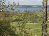 |
The flat surface of this large hillock (247 m above sea level, ~60 m above the surrounding area) offers one of the most beautiful landscapes in Latgale, complete with Lake Rāzna. During the 13th century, the Livonian Order built the Volkenberga Castle on the hillock, and it was thought to be practically impenetrable. Fragments of the castle’s walls remain visible today. |
|
 |
The Dole is the largest island in the Daugava River, surrounded to the Northeast by the rapid waters of the Daugava and to the Southwest by calm and gradually overgrown waters from Dry Daugava. The island is a specially protected nature park, established in 1986 to protect the landscape and cultural and historical values of the island in the wake of the construction of the Rīga hydroelectric power plant, as well as rare and protected species of plants and animals. The island is also meant to provide education and leisure for visitors. Best known on the island is the Daugava Museum, which is in the mansion of the old Dole Estate. The museum features some 13,000 exhibits that speak to the history of the island and the river – Baltic and Livonian apparel, tools and household objects. The exhibition also presents the Daugava as an important waterway and the related history of forms of transport and rafters. In the park is an open-air exhibition with reconstructed lamprey eel traps and a barrier to fish salmon, along with a set of fishing tools. A dolomite cliff is alongside the museum on the steep shore of the Dry Daugava. The ruins of the Vecdole castle can be found on the south-eastern end of the island, near Bēči. |
|
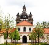 |
Ein hervorragendes Sakralensemble im Barockstil (17 – 18 Jh.), eine Kirche und ein tätiger Nonnenkloster. |
|
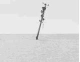 |
The Pape airfield was used for arms training in Soviet times, with bombs being dropped on specific targets. The facility is owned by the regional local government and is not used. There are sunken ships and targets in the sea.
|
|
 |
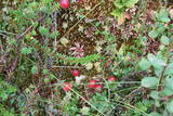
Another area where the manifestations water-soluble lime in the earth can be found. As the lime dissolves, there are empty areas underground which eventually collapse. To the East of Skaistkalne is a leisure area where dry and full holes of various sizes can be found.
|
|
 |
Karulas nacionālā parka lielākais ezers - 2,8 km garš, līdz 1 km plats. Ezera ziemeļaustrumu krastā atrodas parka apmeklētāju centrs. 5,5 m dziļais ezers ir gan zivīm, gan nostāstiem bagāta vieta. Ezera un tuvākās apkārtnes iepazīšanas nolūkā ir izveidota 3,5 km garā Ehijerva taka (Ähijärve teerada). Tās sākums atrodas pie iepriekš minētā apmeklētāju centra, kur izveidota atpūtas vieta un atraktīvs bērnu spēļu laukums. Taka sākumā ved gar ezera krastu, nelieliem mitrājiem un meža ceļiem, kas izmantoti iepriekšējos gadsimtos. |
|
 11 days
|
A panoramic tour of Lithuania, Latvia, Estonia and Finland with highlights of nature experiences in the National parks and nature reserves. A variety of landscapes, nature attraction sites, birds and wild animals, forests and seashore. The tour also offers some cultural and historical insights. |
|
 |
The territory has been established for protection of the bog and its habitat species. It is not appropriate for visits. North-east part of the bog can be slightly seen from the road Neveja – Lapmezciems on winter season. Further on Cirste direction is located on of most impressive oak trees in Latvia – Rigzemju ozols.
|
|
 |
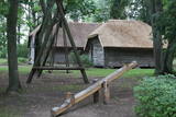
The Krimulda Estate was first recorded in documents in the 15th century. The Krimulda Castle that can be seen now is on the right bank of the ancient Gauja River valley opposite the aerial tram. There are outstanding views of the ancient river valley from the castle and the opposite shore. The Krimulda Castle is a Neo-Classical structure which was built by a local nobleman in the 19th century. In the 1920s, the castle was expropriated and turned over to the Latvian Red Cross, which installed a children's sanatorium there. Today the Krimulda rehabilitation hospital is in the building, and among other structures, the ones that have survived include the stables, threshing barn, servants' quarters, governor's quarters, and the so-called Swiss house. Educational tours are available, and overnight stays are possible at the estate. |
|
 |
This is on the north-western shore of Lake Lielezers of Limbaži, at the start of the Lielezers nature trail. The tower opens up a view of the lake and its lovely shores. It is worth walking the trail, which is several kilometres long, because it is an interesting one. This is part of the ZBR. |
|
 |
The pizzeria is situated in Talsi, not far from Talsu lake. Stender’s pizzeria with its nice comfortable setting offers special Stender’s pizzas which are baked according to the old traditions of pizza-making, incorporating the best of nowadays’ recognitions. Undoubtedly, it is impossible to do without pancakes and pots, as well as second-course dishes. Number of seating places:30 |
|
 |
Suitsu tornis celts 1979. g. kā pirmais Matsalu rezervāta metāla tornis. To atjaunoja 1998. g. Torņa augstums ir 21 m, tādēļ no tā paveras izcila dabas un kultūrainava uz Kazari deltas niedrājiem un blakus esošo Suitsu upi (Suitsu jõgi), kuras krastā ir uzceltas vairākas zvejnieku laivu būdas. |
|
 1 day
|
The Forest Trail leads through smaller paths, arching around Vangaži Lutheran Church and the Werewolf Pine. On its way to the Hunting Palace, it passes the garden created by opera singer Anna Ludiņa and then follows the Hunting trail. The first side ravines with the pronounced relief of the ancient valley of the River Gauja can be seen here. One of them is located by Inčukalns Velnala (Devil’s Cave), surrounded by small river channels of the old Gauja. From there, the Forest Trail continues through meadows and crosses the Murjāņi–Valmiera motorway, where the recreation park “Rāmkalni” is located. In this park, there is a café, shop and active leisure centre with a sledge track. On this route you will mainly see pine forests of various ages, as well as the botanical plantation with 80 tree and 120 shrub species. By the end of the section, the landscape features sandstone outcrops – Devonian sedimentary rocks and habitats protected in Latvia. |
|


