
| Nr | Name | Beschreibung |
|---|---|---|
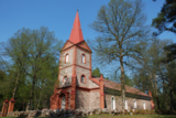 |
The church was built in 1835, and its greatest treasure is the organ, which was built by Karl Bittner in 1854. The manse is being restored. Boats are available for rental. |
|
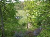 |
The viewing area is near the top of the Vilce castle hill, with a view of the Rukūze River valley, Zaķi meadow, and surrounding forests. This is an unusual landscape for the region of Zemgale. The Vilce baronial estate is nearby.
|
|
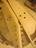 |
Einer der seltenen Kokle-Bauer, der selbst Instrumente baut und anderen beim Bau hilft, indem er Meisterkurse organisiert. Er baut auch andere lettische Volksinstrumente, erzählt darüber, demonstriert sie, berät, sammelt Instrumente und historische Informationen. Er ist im Handwerkerhaus von Drabeši (Drabešu Amatu mājā ) tätig, wo Interessenten auch andere traditionelle Handwerke erlernen können – Weben, Lederverarbeitung, Filzen, Töpfern und eben den Bau von Musikinstrumenten. |
|
 |
Amatnieku biedrība un dāvanu veikals “Pūralāde” atrodas Kandavas vecpilsētā, blakus promenādei. Veikaliņš piedāvā iegādāties Latvijas meistaru un mākslinieku radītos darbus gan dāvanām, gan savām mājām. Amatnieku biedrība organizē dažādu amatu apmācības un radošās darbnīcas. |
|
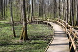 |
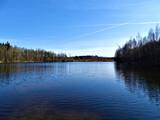
The excessively damp forests at this place include the Vēršupīte River bog, and this is one of the most diverse biotopes in Latvia in terms of the number of species that can be found here. The fact that the area is regularly flooded is shown by the fat roots of black alders – indeed, the place looks like a stand of mangroves. The wooden pathway that is the Dumbrāju trail starts at the Forest House for those who wish to examine the bog. The most impressive views are seen during spring floods or rainy seasons at other times of the year. The little river breaks out of its bed and floods a large territory. The Lake Sloka hiking trail is another place where you can study the Vēršupīte bog. The circular trail is 3 km long, and its beginning is at the Lake Sloka bird watching tower. |
|
 | ||
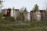 |
Die Transportabteilung der Raketen von Karaosta wird zur Zeit nicht genutzt. Die Abteilung ist relativ eingezäunt, teilweise geschlossenes Territorium.
|
|
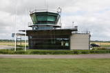 |
Der heutige Flughafen von Ventspils wurde früher als ein Militärobjekt gebaut und als Kriegsflugplatz genutzt. Heutzutage sind die regelmäßigen Flüge nach und von Riga abgebrochen und der Flughafen wird nur für die Bedürfnissen des kleinen Flugwesens genutzt.
|
|
 |
Das Café befindet sich am Weinberg, der seit den Zeiten des Herzogs Jacob bekannt ist, als hier Weintrauben gezüchtet und die sauren Weine von Kurland hergestellt wurden. Lettische Küche: Kalte Suppe, gebratener Zander, geschichtetes Roggenbrot-Dessert, Kartoffelpfannkuchen. Das besondere Gericht: In Sabile hergestellte Hausweine. |
|
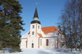 |
Das Gotteshaus hat eine nicht traditionelle Planung und Einrichtung: Der Altar befindet sich in der Mitte, aber die Kanzel – über dem Altar. Die Kirche hat einen eigenartigen Glockenturm mit einer im Jahr 1634 gegossenen Glocke. Die heutige Innenausstattung aus Holz haben die Schüler der Handwerkerschule von Riga geschaffen. Neben der Kirche befinden sich die Ruinen der alten Kirche und das Pfarrhaus, wo am Ende des 18. Jhs. als Hauslehrer Garlieb Merkel gearbeitet hat, der das in Liepupe Beobachtete in seinem bedeutenden Werk Letten verwendet hat. |
|
 |
Neskartu mežu cienītāji var doties izpētīt Plakanciema puses mežu takas. Braucot no Plakanciema pasta nodaļas Mellupu virzienā pa autoceļu V7, pēc aptuveni 1 km jānogriežas ceļā pa labi. Tālāk jādodas uz priekšu vēl 1,2 km. Maršruta sākums - iepretī mājām “Putriņas” ceļa kreisajā pusē, kur sākas meža ceļš. Sākumā maršruts ved pa taisnu meža ceļu. Pēc 500 m nonākam pie ūdenskrātuves (karjera). Šeit ir iespēja doties vai nu gar vienu ūdenskrātuves krastu, vai gar otru. Abās pusēs var aiziet aptuveni līdz ūdenskrātuves pusei un tad griezties atpakaļ. Krastā augošos kokus iecienījuši bebri. Ūdenī peldas pīles, meža ceļa malā vairāki skudrupūžņi, no sakritušo pērno lapu apakšas lien ārā zaķskābenes. |
|


