
| No | Name | Description |
|---|---|---|
 |
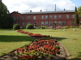
Liepene, in the Ventspils District, was once home to a coast guard division. The facilities are now privately owned and offer accommodations to tourists.
|
|
 |
Apmeklētājiem tiek piedāvāta ekskursija ar stāstiem par Limbažiem, kas kādā veidā saistīti ar sudrabu. Ekskursijas laikā iespējams apskatīt paraugdemonstrējumus lodēšanā. Sadarbībā ar juvelieriem, darbnīcā būs iespējas apgūt prasmes darbam ar misiņu un sudrabu, tiks piedāvātas arī meistarklases. Pēc iepriekšējas pieteikšanās grupām būs pieejamas arī O.Auzera lekcijas par sudraba ietekmi uz veselību. Ekspozīcija atvērta apmeklētājiem no trešdienas līdz svētdienai no pl.10:00-17:00, citā laikā grupām- pēc iepriekšēja pieteikuma. Ieejas maksa: |
|
 |
Atrodas Cēsu rietumdaļā – pie ceļa, kas ved uz Cīrulīšiem. Piedāvājumā – plašs ēdienu klāsts no brokastīm līdz vakariņām. |
|
 |
The first Dnyestr-M radar station was opened here in 1969 to calculate the trajectories of ballistic missiles. The trajectories of satellites were also calculated here. The range of the radar station was 5,000 km. In 1972, construction began on a second, more modern radar, the Dnyepr-M. In 1977, it was ready for use, and the first radar was modernised at the same time. The two radars were located in buildings that were 250 m long and 17 m high. During a 24/hour period, they could identify the height, speed and flight trajectory of up to 750 space objects. In 1985, work began on a third, even more modern radar – the Daryal-YM. This was a radar that could “peek” across the horizon. The antenna building was 117 m high (19 stories), 80 m long and 80 m wide. It had a planned range of 6,000 km, but it was not completed. After the withdrawal of the Russian army in 1995, the building was blown up. That cost LVL 6,172,311 and used up 360 kg of explosives. The territory of the radar stations took up 1,072 hectares, with barracks, a hotel, 551 apartments, a medical facility, a water tower, a war hospital, a bomb shelter, etc. The aim of the facility was to monitor space above Western Europe and North America, as well as to “intercept” any ballistic missiles that were fired at the USSR. The territory is closed to visitors, but it is an important part of Latvia’s military heritage. The abandoned territory can be viewed from the outside. The nearby bus stop is called “Kombināts.” This was the only facility of its kind in the Baltic States. !!! Since March 2018 the Skrunda army base is closed for visitors. |
|
 |
The Rožlejas farm is in the Džūkste Parish of the Tukums Administrative District, where the Eastern Courlandian highlands interact with the Heath lowlands. The parents of the current owner, Jānis Ukše, began work there in 1989, establishing a natural farm to grow sugar beets and then also wheat. Thanks to thoughtful farming, Rožlejas has, over the past quarter-century, turned into one of the largest grain farms in Western Latvia. The owners have taken active part in EU projects to purchase modern equipment and to build hangars for the storage of grain and equipment. The farm specialises in winter barley and winter wheat, using ~1,200 ha of land for that purpose. |
|
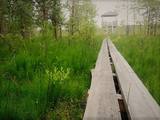 |
Taka ved cauri mežam uz skatu torni purva malā. Takā apskatāma Nāzara priede –priede, pie kuras 1905. gadā nošauts dumpinieks, pati priede – ekoloģiskais koks ar dzilnu kaltiem dobumiem, nokaltusi. Melnalkšņu dumbrājs - slīkšņa ar cūkaušiem un puplakšiem. Oleru purvs no skatu torņa – pārejas un sūnu purvs, kas izveidojies nolaista ezera vietā. Papildus objekti blakus takai, pieejami pa ceļu – Oleru muižas komplekss, Krustakmens, Oleru muižas kapi. Kopējais takas garums: 1,1 km. |
|
 |
The tower on the eastern shore of Lake Engure (next to the meadow for wild cattle, accessible from the side of Bērzciems) offers a view of the reeds, small islands, Great Island, cows and horses of the north-eastern part of the lake. The tower on the northern shore of the lake (accessible from the side of Mērsrags) offers a look at the boating facility and the very overgrown northern part of the lake. The tower at the north-western shore of the lake (accessible from the side of Ķūļciems) shows the Apaļrova island (a footpath), stands of juniper, the boating facility, and the mosaic-like landscape of the lake itself.
|
|
 |
The centre was opened in 2018 with the aim of facilitating tourism in Alsunga and the historical Suiti territory and to offer information about the district, thus establishing a positive and attractive image for Alsunga and the historical territory in Latvia and abroad. |
|
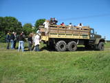 |
Ap 6 km garā pussala ir vieta, kur jānokļūst tiem, kas grasās doties vienā no neparastākajiem pārgājieniem pāri jūras šaurumam. Cauri Kūsnemmes pussalai līdz tās ziemeļu daļai iet šaurs un ļoti līkumains grants ceļš (ar garāku tūristu autobusu jābrauc lēni un uzmanīgi), kura galā izveidots autostāvlaukums, neliels namiņš, kur patverties lietus un vēja laikā, kā arī informācijas stends. Turpat redzamas divas Padomju armijas „KRAZ” tipa automašīnas. Lai sasniegtu robežkontroles posteni, Padomju robežsargi brauca pa jūru un mazajām saliņām, kas kā pērļu virtene savieno Kūsnemmes pussalas galu ar Vilsandi salas dienviddaļu. Turpat divas desmitgades pēc Igaunijas neatkarības atjaunošanas „KRAZ” automašīnu kravas kastēs vasaras laikā uz Vilsandi vizināja tūristus, taču spēkrati savu mūžu ir nokalpojuši un unikālais piedāvājums vairs nav spēkā! Ko darīt? Pa mazajām saliņām uz Vilsandi var doties ar kājām. To var īstenot tikai siltā laikā, kad nav gaidāms stiprs vējš un ir zināma laika prognoze vismaz divām tuvākajām dienām. Kā sava veida orientieris var kalpot augstsprieguma elektrolīnija. Kopumā ir jārēķinās arī ar 1 h 40 – 2 h ilgu un ~ 4 km garu gājienu. Dziļākā vieta (ja ietur pareizo „kursu”) atrodas pārgājiena sākumdaļā, kur starp saliņām izveidots laivu ceļš - ~ 1 m dziļa vieta atkarībā no vēja virziena un ūdens līmeņa. Zināmu priekšstatu par maršrutu sniegs redzamā ainava, kas paveras no skatu torņa. Kaut arī šis maršruts tiek reklamēts dažādos informatīvajos materiālos, atbildību par tā veikšanu uzņemas katrs pats! |
|
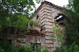 |
Atrodas Kraujā – Daugavas ielejas krasta malā un nogāzēs. Atrodama informācija, ka šajā vietā Livonijas kara laikā atradusies krievu karaspēka nometne. Muižas nosaukums cēlies no vācu Hof zum Berg – „Kalnu muiža”. Pēdējie muižas īpašnieki līdz 1. pasaules karam bija grāfu Šahno dzimtas pārstāvji. Viens no tiem – Marians Šahno 1910. gadā uzceļ muižas pili, kas bija būvēta eklektisma formās. Daļēji nojaukta tā pārdzīvo padomju laikus, līdz 2002. gadā nodeg. Līdz mūsdienām saglabājušās vien ēkas sienas, kuras slēpj biezs augājs. Var tikai iedomāties, kādi skati šeit kādreiz pavērušies uz Daugavas ieleju! Muižas parks ir vietējo iedzīvotāju pastaigu vieta. |
|
 |
Neliela siera ražotne Ādažos, kas apvieno tradicionālas sierdarīšanas metodes ar mūsdienīgu izpratni par strauji augošo bioloģiskās pārtikas tirgu. Sieru gatavošanā tiek izmantotas tikai divas sastāvdaļas - piens un sāls. Pārējo nodrošina darināšanas veids, baktērijas un pelējumi, kas savu darbu veic jau nogatavināšanas procesā. SieriSoira piedāvā vairāk nekā 20 siera šķirnes – no svaigajiem un maigajiem līdz izteiksmīgiem, ilgi nogatavinātiem cietajiem sieriem. Īpašs lepnums ir premium zilie un pelnu sieri, kuru niansētās garšas ir novērtējuši gan starptautiski eksperti, gan Latvijas gardēži. Kā top siersSiera ražošanā tiek izmantots piens no Latvijas zemnieku ganībām, kur govis dzīvo brīvā dabā. Piens netiek pasterizēts, saglabājot visas dabiskās garšas nianses. ApmeklētājiemIespējams iepazīt siera tapšanu klātienē - apskatīt ražotni, ielūkoties pagrabu plauktos un nogaršot sierus turpat uz vietas. Kur iegādāties sierusRažotnē Ādažos. E-veikalā: www.soira.lv. Specializētajos pārtikas veikalos un Rīgas tirdziņos. Soiras sierus iespējams nobaudīt arī dažādos restorānos. |
|
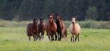 |
The “Dabas zirgi” centre for horse and human welfare is in the historical Mežinieku neighbourhood in suburban Rīga, and it will be a revelation to those who wish to have a sense of belonging related to Latvia and its environment. Touch the forest, enjoy the cool water of the Misa River, encounter a swamp or see the breath of a horse on a foggy morning. You’re welcome to spend a longer amount of time at this venue with new glamping opportunities in a lovely forested area next to the steep shores of the Misa River. This offers complete silence with only the woods and the river nearby. Along with the horses, of course. “Dabas zirgi” offers strolls with a horse, tours involving feeding the animals, as well as horseback rides. Family celebrations are perfect here with a lean-to, a grill, and a pot on a campfire. Contact the venue in advance to arrange for prepared breakfast, lunch and dinner. There is also a sauna with a jacuzzi. |
|
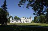 |
The Castle was restored recently and now exhibits life and history of a noble family on three floors. Tour guides have numerous stories and legends to tell, visitors can make their personal castle souvenirs. |
|
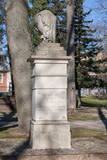 |
In 1877, Baron August von Pistohlkors, celebrating the merits of his ancestors in the foundation and development of Neibāde, ordered a monument to be erected in the park. After World War I, in the early 1930s, the monument was accidentally found during the cleaning of the bed of the River Ķīšupe. The monument was renovated by the Neibāde Aid and Improvement Society and officially reopened in 1933. The monument also suffered damage after World War II. Now the monument is restored and located in the park of the open-air stage. |
|
 |
Kihnu is the largest island in the Gulf of Riga with an area of 16.4 km2, it is only 7 km long and 3.3 km wide. There are four villages on the island and the unique atmosphere of the island can be experienced by visiting a local family at Kuraga Farm. Three generations live in this farm and are happy to welcome guests. |
|
 |
This is an ancient populated area. There were 50 homesteads here during the 1930s, with only ten remaining in 1990. The Livonian scholar and entomologist Kārlis Princis (1893-1978) was born in Oviši. In 1944, he emigrated to Sweden. The Oviši lighthouse (1814) is 38 metres high and is the oldest functioning lighthouse in Latvia. There are lovely views from the top of the lighthouse. The building in which employees of the lighthouse used to live was erected in 1905 and has been preserved. A narrow-gauge train station was in the building at one time. The Oviši Lighthouse Museum is nearby, as is the metal Tree of Austra. Opposite Cape Oviši is a great place for bird watching. |
|
 |
The Forest House (Meža māja) was built
in 1933, and this is one of the most
outstanding buildings in Latvia from the style
of National Romanticism. It used to house an
enormously popular restaurant, “Merry
Mosquito" (Jautrais ods). The restaurant was
popular among the spa’s guests, but also
among prominent people of the day. A
children’s sanatorium was installed here after
World War II for kids from all over the Soviet
Union. When the Ķemeri National Park was
established in 1997, the building became its
headquarters and today it is a modern visitors’
centre.
|
|
 |
Apmeklētāju centrā var iegūt noderīgu informāciju un iepazīt ekspozīciju par Karulas augstienes veidošanās vēsturi, ezeru iemītniekiem un šejienes novada kultūrvēsturiskajām tradīcijām. Apmeklētāju grupas semināru zālē var noskatīties izzinošu prezentāciju. |
|
 |
Piedāvā ļoti gardus Lietuviešu tradicionālos ēdienus. Var pieņemt līdz 140 personām. Ir āra terase un dzīvā mūzika. Pieņem bankas kartes, pieejama autostāvvieta. |
|
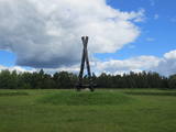 |
Not far from the Rīga ring road on the Right Bank of the Daugava is a monument designed by the sculptor Ģirts Burvis in 1994, which is dedicated to the Livs of the Daugava region and their Mārtiņsala leader, Ako, who led a battle against the Holy Crusades in 2016. Around the monument is a large area for leisure and perambulations. This is one of the loveliest locations in the lower reaches of the river. A bit further along are information stands about the history of the banks of the river before the construction of the Rīga hydroelectric power plant. |
|


