
| No | Name | Description |
|---|---|---|
 |
The farm shows traditional rural life activities, raising sheep and Estonian Blackhead sheep. A heritage trail on the farm takes in a sacred grove, ancient burial sites and fields, and we tell stories of ancient Estonians and history of the farm. Handicrafts are displayed and wool workshops are offered. |
|
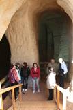 |
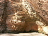
The area of the ancient Piusa River valley that is between the villages of Vana-Vastseliina and Ignasõ is around 15 km long, features some substantial rapids, and offers a view of beautiful Devonian period cliffs. The largest, Härma müür, is 43 metres high and is the highest sandstone cliff in Estonia. There are caves from old mines in the village of Piusa. A small part of the mines, which have tunnels that are more than 10 km long in all, has been tured into a local museum.
|
|
 |
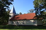
The Viesīte Lutheran Church is in Kaļķu Street in the western part of Viesīte, on the so-called Vales hillock which was left behind after the Ice Age. An interesting fact is that the defenders of Viesīte defeated the Bermont army here in 1919. The cornerstone for the church was laid on August 15, 1937 (a commemoration day for military heroes). The building was consecrated in 1939 and restored in 1994. Financing was provided for the construction of the church by Professor Pauls Stradiņš. The altar painting is by Ligita Caune. To the East of the church, at the foot of the Vales hillock is a monument to Stradiņš. |
|
 |
For more than a century now, the Gūtmaņa cave has been a popular tourist destination. It is the widest (12 m) and highest (up to 10 m) cave in Latvia. It is more of niche, actually, because its depth is just 18.8 metres. The cave is an interesting geological monument, as well as an important cultural and historical place with lots of legends, among which the most popular one centres on a woman called the rose of Turaida. It seems, however, that of the greatest historical values are the engravings on the walls and ceilings of the cave. The oldest date back to the late 17th century. A stream flows out of the cave, and it continues to shape it. People believe that the water from the stream has medicinal properties. Nearby there is Tourist Information Centre Gutmanala. Office hours: 01.05.-30.09. from 9.00 – 19.00; 01.10.-30.04. from 9.00 – 18.00. Prices for parking: 1 car EUR 2,50; 1 minibus EUR 5,00; 1 bus EUR 7,00. |
|
 |
The Atāli homestead is on Putnu Island, and a local researcher, Ārija Gruberte, has used the threshing barn to exhibit everyday objects used in the area of the ancient Dviete River valley over the course of time. She has collected these items over the course of 20 years, and they include objects dating back to the Stone Age, the Iron age and the Middle Ages. All of them speak to human lives over the course of more than 10,000 years. Please call in advance to arrange for a tour. |
|
 |
according to legend, was washed into the sea because of collapsing shores along with other buildings and the old road. The church was built in 1862 and has an altar painting from the late 19th century, "Mother of God," along with an organ. The metal elements of the building's doors are interesting. Hanging from the ceiling of the church is a sailing ship that has to do with the rescue of the crew of the sunken ship. |
|
 |
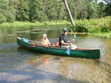
Kihnu farm offers traditional Kihnu island dishes from home-grown vegetables and local fish. |
|
 3 days
|
This route section takes you to the Dzūkija National Park – it is among Lithuania’s most forested and desolate nature areas –, and to the town of Druskininkai – a popular SPA and mineral water health resort on the banks of the river Nemunas. When in Druskininkai, we recommend dipping yourself in mineral water baths, enjoying the trip with the cable car over the river Nemunas, visiting the musical fountain, and walking along the river promenade. The starting point of the hiking route is the village of Didžiasalis, which is reached by bus from Druskininkai. From there, the route will take you through vast coniferous forests, rich in berries and mushrooms, and small villages. As you get to Druskininkai, the Forest Trail will meander along the small streets and parks of the historic resort of Druskininkai, crossing the river Ratnyčia and the forest park on the right bank of the Nemunas valley. Leaving the resort town behind, the Forest Trail runs on the side of the village revealing you the beautiful landscapes and the view of the Liškiava monastery on the other bank of the river Nemunas. Up to the village of Žiogeliai, the route goes along forest roads and continues along the banks of the Nemunas valley, surrounded by the vast Dzūkija forests. Towards the end of the route, climb up the Merkinė Mound and it will surprise you with breathtaking views of southern Lithuania. |
|
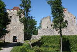 |
Exploring of Sigulda can be started with a visit to Sigulda castle ruins. The construction of the castle was begun by the Knights of the Sword Order in 1207, but in 1236 it was rebuilt for the needs of the Livonian Order. Sigulda castle suffered much from the wars in the second half of the 16th century and in the beginning of 17th century. During the Northern War, it is burned down and is no more restored. Today south-western building of the convent and the tower of the main gate, behind which is the inner forefront of the castle with open air stage, which offers impressive views over the Gauja valley. Currently the reconstruction of castle ruins is in progress. Construction of New castle (owner - Prince Kropotkin) in the South of the Sigulda took place from the 1878 until 1881. From 1923 - 1940 the building was the Palace of Writers, but during the Soviet years - Cardiology sanatorium. Since 2003 Sigulda district council is located there. The manor complex includes wooden house (middle of 19th century), which was Kropotkin's family home, barn (turn of the 18th - 19th century), gardener's house (19th century) and a stone fencing (19th century.) If we make our way from New Castle in a north-eastern direction, after almost 2 km we will reach Vejupite ravine. There you can see the shallow (3.6 m) but high (6.1 m) in Peter's Cave and deep Pucu ravine with Krauklupite. At the conjunction of ravines of both streams rises a Satezele hill fort (plateau 90 x 75 m), where in the beginning of 13th century was the oak castle of Liv land chief (eldest) - Dabrelis. Near can be found Krauklu gorge - ravine of Vejupite left bank, with 11 m high sandstone walls and 5.2 m deep Krauklu cave. At the conjunction of Vejupite ravine and Gauja valley columns Paradise (Gleznotaju) Hill - a very picturesque place, painted and photographed since old times! The Paradise Hill can be reached with a electric vehicle. In the west part of Sigulda is located Ferris wheel (works during the summer) and Air cableway (streetcar) - the only this type of vehicle in Baltics (built in the 1969). Its self-supporting cable extends in 1060 m length and without any support joins the Gauja River valley banks between Sigulda and Krimulda ~ 40 m above Gauja River. Here you can enjoy excellent views! In the south-western part of Sigulda one can walk to mighty Beites precipice, which is split by the deep ravine of stream. On the west side of the ravine lies Keizarskats, which is located ~ 67 m above the Gauja level and offers good views of Krimulda and Turaida castle. Sight place was arranged here already in the 1862 when Russian Tsar Alexander II visited Sigulda. In the eastern part of the ravine wooden Keizarkrēsls (Emperor Stool) is located. |
|
 |
The restaurant is in the “old school” of Ungurmuiža. Together with the nobleman’s estate and park, this makes up a unique cultural and historical monument. Latvian cuisine: Potato pancakes with cured meet and loganberry jam, chanterelles soup, vegetable soup, porridge with meat, Brasla trout, roast pork with rhubarb sauce, manna, desserts with berry sauce. |
|
 |
Ūla ir viena no skaistākajām un likumsakarīgi – arī populārākajām Lietuvas ūdenstūristu upēm. Tās galvenā pievilcība ir skaistā ainava ar augstajiem upes krastiem, kuros slejas iespaidīgas smilšu kraujas līdzīgi kā Irbes krastos Latvijā. Laivošanu var sākt no Mančagires (Mančiagirė) vai Zervinos ciemiem un turpināt līdz Ūlas ietekai Merķē un tālāk pa Merķi līdz pat Merķinei un Nemunai. Ūla nav plata, taču posmā no Zervinos ciema tajā nav neviena koku aizgāzuma vai cita šķēršļa, kuram laiva būtu jānes apkārt. Ašā straume, asie līkumi, dzidrais ūdens un tajā redzamā zemūdens pasaule rada patiesi patīkamu sajūtu! Upes krastos atrodas gan publiskas (apsaimnieko Lietuvas valsts meži), gan privātas ūdenstūristu apmetnes un atpūtas vietas. Šī ir vienīgā Baltijas upe, kur ūdenstūristiem ir jāpērk licence. Ūlas krastos atrodas divi interesanti apskates objekti – Ūlas atsegums (Ūlos atodanga) un spēcīgs avots – Ūlas acs (Ūlos akis). Savukārt, Merķe jau ir jau krietni platāka upe, taču ar acīm redzamu straumi un dažviet pat jaukām straujtecēm. Kaut arī Merķes krasti ir mazapdzīvoti, tajos atradīsim piemērotas nakšņošanas vietas. Pa Ūlu un Merķi no Zervinos līdz Merķinei sanāk „mierīgs” pusotras - divas dienas ilgs brauciens. |
|
 |
A fish processing plant which has collapsed down to its foundations (it
ended operations in 1978)
|
|
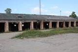 |
In Soviet years, Ventspils was the site of tank training. The facility has been degraded, and only the former tank repair facility and some outbuildings are still being used. The rest of the territory is not used or guarded any more.
|
|
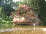 |
This is one of the most beautiful and popular tourism locations in Vidzeme. The cliff is 45 metres high, and the height of the lovely open-faced portion is around 20 metres high. You can look at the wide and deep Amata River valley and its forested banks.
|
|
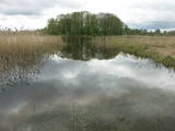 |
Dabas liegums veidots ezera, tā salu, ainavas, augu, putnu un sikspārņu aizsardzībai. Liegumu var apskatīt "no malas" - no ceļa, kas iet gar tā ziemeļu un ziemeļaustrumu robežu.
|
|
 |
A gourmet’s favourite in the very heart of Valmiera, opposite Valmiera Town Hall Square. Here every guest can become a gourmet and enjoy a variety of flavour "bouquets" and seasonal products that come from local farms. The restaurant's Summer Garden is designed to highlight Valmiera as a Hanseatic city of a medieval merchant association. Latvian cuisine: A selection of Latvian cheeses, Valmiera salad, potatoes in their jackets with cottage cheese, cold kefir soup, lamb soup, pike from Lake Burtnieks, baked filet of catfish, leg of lamb steak, roast pork ribs. Special foods: Rye bread baked in honey. |
|
 |
Sēlijā, Zasas muižas parkā, atrodas “Bērzzemnieki”, kur saimnieko Kalnāju ģimene. Atjaunojuši vēsturisko māju un ieveduši staļļos zirgus, ģimene sniedz viesiem iespēju iepazīt zirgus, piedalīties dažādos ikdienas darbos un doties izjādēs, kā arī nakšņot “muižiņā”. |
|
|
|
Die Ruinen der um 1500 gebauten eindrucksvollen Kirche, die man besichtigen kann. Das Gebäude wurde nach dem Luftangriff 1942 beschädigt. |
|
 |
Dabas liegumā "Pilskalnes Siguldiņa" ir izveidota dabas taka - kājinieku tūrisma maršruts – t.s. Augšzemes ainavu taka, kas sākas Pilskalnē un beidzas pie Driģeņu mājām. Tā izlīkumo ezeru krastus, šķērso purvu (laipas). Apmeklētājiem, t.sk. arī bērniem, izveidotas arī īsākas - lokālas takas. Pieejami dažādu taku garumi: 1,6 km, 3,8 km, 8 km. |
|
 |
This farm produces organic grains, and it has a bakery at which tasty rye bread, wheat-rye bread and croutons for bread yoghurt are produced. Bread can be purchased on site.
|
|


