
| Nr | Nosaukums | Apraksts |
|---|---|---|
 |
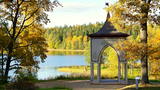
Šūpošanās ir veselīga nodarbošanās, šūpoles ir enerģijas uzkrāšanas avots. Kad dabā veidojas spēcīgs enerģijas maksimums, šūpojoties iespējams saņemt īpaši daudz. Šūpoles ļauj atrauties no zemes, kaut uz mirkli. Parka teritorijā ir brīvdabas pavarda vieta un pirts. Saimniece piedāvā profesionālus pirts rituālus un nakšņošanas iespējas. |
|
 10 dienas
|
From Vilnius the route goes to picturesque Trakai Castle surrounded by lake from which it continues to Dzūkija National Park. The park introduces with traditional Lithuanian way of living, closeness with forest as well as valuable natural resources. Information centre and centre of etnoculture is located at Marcinkonys but Čepkelių raistas provides atmospheric vast bog landscape. Pleasant forest trails and quite roads are pleasant for cycling. Druskininkai is a historic spa resort with charming old town, many spa hotels, walking trails and entertainment facilities. There is the Grutos Park where monuments from Soviet area is collected in order to demonstrate the former oppressive ideology. From there the road heads to lively Kaunas which sits between two rivers -Nemunas and Neris. |
|
 |
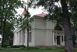
Alūksnes muižas parks atrodas pilsētas austrumu daļā un aizņem 25,54 hektārus lielu platību. Tas ir atzīts par skaistāko parku Vidzemē un ikviens, kas tajā pabijis, ir sajutis parka burvību un skaistumu. Parkā ir saglabājušās vairākas mazās arhitektūras formas. Ieeja parkā ir no Alūksnes Jaunās pils puses. (Avots: Alūksnes TIC) |
|
 |
4 km garā un marķētā taka iepazīstina ar dziļo Imulas ieleju – Abavas kreisā krasta pieteku. Īpaši iespaidīga ieleja izskatās bezlapu periodā, kad ir apjaušami tās izmēri un formas. Vēstures cienītāji var upes gultnē uzmeklēt Langsēdes Velna pēdas akmeni. Atrodas dabas parkā „Abavas senleja”. |
|
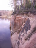 |
Šis smilšakmens atsegums kādreiz ir saukts arī par Pieškalnu vai Pieškaļu iezi. Tas meklējams ap 7 km ziemeļos no Cēsu centra. Ērģeļu klintis ir monolītākā Baltijas smilšakmens klinšu siena: garums ~ 700 m (ap 330 m garu to daļu apskalo Gauja), maksimālais augstums līdz 22 m. No klinšu skatu laukuma atklājas plašs skats uz Gaujas senleju. Arī ūdenstūristi, kuru priekšā pacelsies majestātiskā siena, būs pārsteigti par pieredzēto! Klinšu nosaukums esot radies no atbalss, kas it kā skanējusi kā ērģeles. Aplūkojot klintis, gan kājiniekiem, gan ūdenstūristiem ir jāievēro personīgā drošība! |
|
 |
Restorāns "Orizzonte" atrodas pašā jūras krastā ar divām terasēm un visaptverošu skatu uz Jūrmalu. Latviešu virtuve: Marinēta siļķe ar biezpienu, kartupeļu pankūkas, cepta Baltijas bute, jēra kumbrs, Latvijā ražoti sieri. |
|
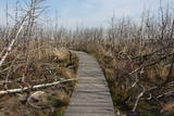 |
Braucot no Kopgaļa uz Jodkranti (Juodkrantė), autoceļš „uzskrien" Lāča galvas kāpā (Meškos galvos kopa), kur kreisajā (austrumu) pusē paveras dīvains skats ar sausiem kalnu priežu Pinus montana stumbriem, kas atgādina spocīgu pasaku mežu. Šeit 2006. g. pavasarī notika t.s. gadsimta ugunsgrēks, kā rezultātā izdega simtgadīgs priežu mežs 235 ha platībā. Vietas apskatei ir izveidota koka laipa. |
|
 |
Meklējama Krustpilī, Mazās Daugavas labajā krastā - Rīgas ielā 211 a. Tagadējā mūra baznīca (iepriekš šeit bijušas divas citas) celta laikā no 1818. - 1820. g., bet iesvētīta 1824. g. Dievnams ievērojami cieta 1. pasaules kara laikā. To atjaunoja 1924. g. Baznīcā atrodas vairāki ievērības cienīgi kultūras pieminekļi - altārglezna “Kristus Ģetzemanes dārzā lūdz Dievu”, ērģeles (stabules izgatavotas Vācijā) u.c. 1999. g. dievnamam, ko uzskata par vienu no Latvijas spilgtākajiem ampīra stila arhitektūras paraugiem, piešķirts Eiropas kultūras mantojuma zilais karogs. Saglabājušies nostāsti par slepenām pazemes ejām uz rietumos esošo Daugavsalu. Ikdienā baznīca apskatāma g.k. no ārpuses. Netālu no baznīcas apskatāmi divi pieminekļi – politiski represēto un nacionālo partizānu piemiņai. |
|
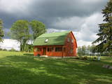 |
Viesu māja Sila ezera krastā. Vasaras māja, atsevišķā ēkā pirts un atpūtas telpa ar kamīnu. Pirts mājā - kamīnistaba, pirts, duša, 2-vietīga guļamistaba. Vasaras mājā - viena istaba ar 2 atsevišķām gultām, sausā tualete. Makšķerēšanas iespējas, laivas, ugunskura un telšu vietas. |
|
 |
Paides ordeņa pilī Vallimē ir izveidots Wittenstein laika centrs, kur laika mašīnas funkcijas pilda lifts, kas apmeklētājus pārved no viena laikmeta otrā. Dažādos stāvos var iepazīties ar senajiem un ordeņa laikiem, karaļu un caru laikiem, okupācijas periodu, neatkarīgās Igaunijas un neatkarības atdzimšanas laiku. Centrā ir plaši izmantotas skaņas un gaismas, videoprogrammas un ilūziju radoši efekti. |
|
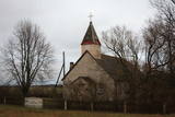 |
Nelielā izmēra ēka (balts ķieģeļu mūris, ar dēļiem apšūts zems tornis) atrodas Liepājas – Klaipēdas šosejas (A 11) malā. 20. gadsimta sākumā tā kalpojusi kā lūgšanu nams, taču tā paša gadsimta vidū pārbūvēta, uzceļot torni. |
|
 |
Meklējams Virgas centrā. Asprātīgā piemiņas zīme (tēlnieks R. Gabaliņš, mākslinieks R. Kalniņš) – zābaks ar diviem pretēji vērstiem lielgabaliem un lodēm vēsta par Ziemeļu kara laika notikumiem, kad 1701. g. Virgā bija izveidota zviedru karaspēka nometne. Stāsta, ka karalis Kārlis XII savu zābaku pazaudējis citā reizē un vietā - Spilves kaujā pie Rīgas. |
|
 |
Viens no izteiktākajiem Latvijas piekrastes zemesragiem ar piejūras palieņu pļavām un 1875. g. celto bāku. |
|
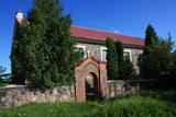 |
Atrodas Subates vēsturiskajā centrā. Ēka (nav torņa) celta no laukakmeņiem 1831. g. par grāfa Mihaila Zīberga – Plātera līdzekļiem. Tā priekšpusē slejas iespaidīgs zvanu tornis. Dievnamā atrodas 18. gs. beigu skulpturālā grupa “Golgāta”, krucifikss un nozīmīgs galvenā altāra cilnis – kokgriezums. Pēdējais tapis pēc slavenās Leonardo da Vinči freskas “Svētais vakarēdiens” motīviem. |
|
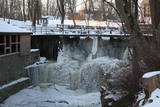 |
Atrodas pie Kuldīgas pils dzirnavām, kur straujā Alekšupīte pirms ietekas Ventā izgrauzusi dziļu „kanjonu” dolomītā. Šo dēvē par vienu no augstākajiem Latvijas ūdenskritumiem (4,15 m). 17. gs. ūdenskritumu ievērojami pārveidoja – paaugstināja un nostiprināja, lai Alekšupītes straumi izmantotu dzirnavu darbināšanai. Upītes kreisais krasts ir labiekārtots. |
|
 |
Sigita un Kārlis Smiltiņi ir latviešu tradicionālo vērtību sargātāji. 2010. gadā, dzimstot idejai par rudzu maizes cepšanu, abi salabojuši veco laiku maizes krāsni, kuru nu jau izmanto ceturtā paaudze, lai latviešiem tik ļoti svētītais darbs - maizes cepšana neietu zudībā. Smiltiņu mājās - Ventspilī, viesiem ir iespēja aplūkot rudzu maizes un auzu karašas cepšanas procesu. Apmeklējums iepriekš jāpiesaka, vienlaikus saimnieki var uzņemt ne vairāk kā 5 cilvēkus! |
|
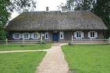 |
Atrodas Kaibēnu kalnā (226 m v.j.l.) – 7 km uz rietumiem no Inešiem. Nominēts kā Latvijas vecākais (no 1929. g.) memoriālais muzejs. „Kalna Kaibēnu” ēkas ir celtas laika posmā no 18. – 19. gs., un tajās apskatāmi tautskolotāju un rakstnieku Reiņa (1839. – 1920.) un Matīsa (1848. – 1926.) Kaudzīšu pašu būvētā veranda, kāpnes, sienas skapji, parketa imitācijas un R. Kaudzītes izveidotā ratiņu virpotava. Ratnīcā ir izvietota seno darba rīku kolekcija. Autentisko viensētu ieskauj rakstnieku stādītais dārzs ar koktēlnieka K. Kugras veidotajiem romāna “Mērnieku laiki” tēliem. „Kalna Kaibēnos” tapis leģendārais romāns „Mērnieku laiki”. Laikā no 1868. – 1882. g. dzīvojamā ēkā atradusies pagastskola, kurā Matīss strādāja par skolotāju, bet Reinis – par skolotāja palīgu. Muzeju ieteicams apskatīt gida pavadībā. |
|
 5 dienas
|
Vēsturisko ceļu no Rīgas uz Liepāju cauri Dobelei, Saldum, Skrundai, Durbei un Grobiņai var izsekot jau no seniem laikiem, pat sākot no 13.gs. Par ļoti seniem laikiem liecina arī skandināvu apmetnes paliekas Grobiņas tuvumā. |
|
 |
«Silkalnos» apmeklētāji var iepazīties ar visdažādākajiem pļavās, tīrumos un dārzos, mežos un purvos, pagalmos un puķudobēs augošiem ārstniecības augiem, kā arī to lietojumu veselības uzturēšanā. Ekskursiju laikā saimniece iepazīstina ar ārstniecības augiem, to audzēšanas, vākšanas, kaltēšanas un tēju maisījumu, sīrupu, izvilkumu gatavošanas noslēpumiem. Tūristi saimniecībā var degustēt un iegādāties ārstniecības augu tējas. Īpaši piesakot, saimnieks interesentiem parāda un pastāsta par dabas enerģijām - āderēm un akmeņu spēku.
|
|
 1 diena
|
Dodieties ekskursijā, lai gūtu ieskatu lauku profesijā un dzīvesveidā, kā arī iegūtu jaunus iespaidus un labu atpūtu visai klasei. Ekskursijas laikā apmeklējiet ekopoligonu, kas ir unikāls piemērs ekoloģiski saderīgu darbības virzienu ieviešanai. Pēc tam apmeklējiet saimniecību, kurā iespējams aplūkot Latvijas tumšgalves aitas, uzzināt par to audzēšanas specifiku, dzīves paradumiem un aitkopības nozari Latvijā, kā arī iespējams aplūkot dažādus putnus - tītarus, zosis, pīles, vistas un pērļu vistas. Saimniecībā atrodas arī observatorija, kur var noklausīties lekciju par zvaigznēm, planētām un citām tēmām. Ekskursijas noslēgumā dodieties uz kokapstrādes darbnīcu, lai meistaru vadībā darbotos ar tradicionālajiem kokapstrādes instrumentiem un apgūtu senās spēles. |
|


