
| Нo | Название | Описание |
|---|---|---|
 |
Находится в Авеньмуйже при въезде в Бауску, напротив Музея машин. Народно - исторический интерьер, что позволяет посетителям удобно отделиться от остальных. Латышская кухня: Овсяная каша, молочный суп, тыквенный суп, холодный свекольный суп, домашние котлеты, картофельные и тонкие блины, хлебный суп. |
|
 |
Radošajā galerijā var apskatīt vairākas ekspozīciju zāles ar skulptūrām no moto/auto detaļām, individuāli pārveidotiem motocikliem, kuriem ir savs stāsts un filozofija. Latvijā vienīgais ar šādu mākslu un piedāvājumu saistīts uzņēmums. Apmeklētājiem ir iespēja doties nelielā ekskursijā, galerijas apskatē ar gidu. Pēc apmeklējuma ir iespēja doties uz kafejnīcu, kurā var nobaudīt kafiju un mājās ražotus kulinārijas izstrādājumus, arī noskatīties dažādas video īsfilmas par uzņēmuma darbību. Pieejama unikālo NESTER CUSTOM suvenīru iegāde. |
|
 |
Находится в центре Салацгривы на площади Боцманя, около Салацы. Когда-то столь известная корчма «У боцмана» приобрела новый интерьер, связанный с тематикой барона Мюнхгаузена. Латышская кухня: Салат из селедки, селедка с творогом, рыбный суп, свиная грудинка с луком, серый горох с салом, жареная печень, жареная камбала, жареное филе судака, слойка из черного хлеба. |
|
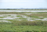 |
Озеро Лубанас, Лубанские топи. Озеро Лубанас по площади самое большое озеро (80,7 кв.км) в
Латвии, самое большое запруженное озеро в Европе, а территория вокруг него по биологическому
разнообразию – уникальное место не только в Латвии, но и в международном масштабе. Природный
заповедник включен в сеть (NATURA 2000) защищаемых территорий Европейского союза и
соответствует критериям Рамсарской конвенции, т.е. топи международного значения. Лубанские топи,
которые местное население уже издавна называет плавнями, – низкие и высокие болота, мокрые
луга, влажные леса. Осенью и весной на водохранилищах останавливаются тысячи мигрирующих
водоплавающих птиц, за которыми удобно следить из башен наблюдения за птицами либо с террасы
центра развития водного туризма.
|
|
 |
Новаторские и вкусные продукты из конопли и гречки ‒ и вкусны, и полезны для желудка. |
|
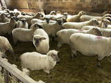 |
На просторных лугах хозяйства по берегам реки Айвиексте пасется крупнейшее в Латвии стадо Латвийских темноголовых овец (~ 400 животных). Осмотр хозяйства, приобретение породистых овец, мяса, шерсти, кожи и овощей. |
|
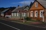 |
Центральной части Краславы, для которой характерна красивая невысокая деревянная застройка, присвоен статус памятника культуры. Лучшие виды на исторический центр города открываются с автостоянки у тропы Адамова, горы Карницкого, прилегающей территории к мосту через Даугаву (улица Проспекта) и смотровой вышки Приедайне на левом берегу Даугавы. |
|
 |
Идея центра ‒ укреплять здоровье, питаясь чистыми продуктами, поэтому здесь предлагается насладиться вкусом лишь слегка обработанных и богатых витаминами продуктов. По большей части здесь используют свежие продукты, выращенные в саду при Центре и в окрестных хозяйствах. Специально разработанные курсы питания включают вкусные овощные супы и разнообразные рагу, а также различные каши. Лечебные курсы предполагают не только определенное питание, но и процедуры, и тренировки, которые нужно заказывать заранее. |
|
 |
Plateļu dienviddaļā plešas sakoptais Plateļu muižas (muižas vēsture ir zināma, no 16. gs.) parks, kura centrā aug Raganu osis – dižkoks 7,2 m apkārtmērā. Parkā un tā tuvākajā apkārtnē ir redzamas muižas saimniecības ēkas. Vienā no tām – atjaunotajā zirgu stallī ir izveidots muzejs, kurā var apskatīt unikālas 250 vietējo meistaru darinātās maskas. Pašreiz šī ir lielākā šāda veida masku kolekcija Baltijas valstīs. Plateļu ezerā ir atrastas trīs no ozolkoka taisītas vienkoča laivas. Viena no tām (darināta 16. gs.) atrodas Lietuvas Jūras muzejā. Otra (15. gs.) ir apskatāma atjaunotajā Plateļu muižas graudu glabātavas pagrabā (Didžioji gatve 22), jo šobrīd tiek restaurēta. Trešā laiva arī izlikta apskatei kā muzeja eksponāts. |
|
 |
В хозяйстве, что расположилось на берегу реки Рауна, разводят разные породы рыб. Зимнее предложение включает ловлю лососёвых, а летом предлагается рыбалка на осетра, сига, тилапию и форель. В «Силлакас» можно и купить рыбу. Для туристических групп проводится дегустация рыбы. «Силлакас» находится примерно в 3 км от «Лиепасмуйжас». |
|
 |
Starp cilvēku un zirgu valda īpaša saikne, ne velti zirgs cilvēkam spēj būt gan draugs, gan palīgs, gan sabiedrotais dažādās dzīves situācijās. Saimniecība “Imanti” piedāvā braucienus zirga kamanās ziemā un ratos – vasaras sezonā. |
|
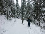 |
The nature park near the town of Ogre is a popular place for leisure, hiking and, in the winter, cross-country skiing. Most of the park is covered with coniferous trees that are on a long and comparatively narrow line of hillocks with steep sides – another element of nature left behind in Latvia by the Ice Age. Many different plants can be found here. The Jaunogres castle hill is one of the most distinct hillocks in the area. |
|
 |
Калевипоэг- герой Эстонского национального эпоса, и именно Йыгевамаа тесно связано с историями о нем. Здесь меч Калевипоэга в реке Кяапа, места отдыха, камни, родники, болота, вспаханные борозды, следы лошади и т. д. В музее Калевипоэга 12 тематических комнат, где представлены связанные с ним материалы и Эстонское культурное наследие. Перед зданием музея- заповедный сад и 17 деревянных скульптур героев эпоса. |
|
 |
Находится в 0,3 км от Юркалнского обрыва. Расположено в историческом восстановленном деревянном здании. Латышская кухня: Суп-пюре из серого гороха, коча (перловая каша) с боровиками, купиняс (простокваша, кефир, творог, картофель, тмин), селедка с творогом, серый горох с салом, блюда из морской рыбы, бигузис (десерт из черного хлеба). Особое блюдо: Десерт с облепихой и медом. |
|
 |
Zilais (Blue) Hill is the highest point in the Idumeja highlands – it is a very distinct hillock covered by forest, and from it there is a “narrow” landscape featuring the northern part of the highlands, as well as the Burtnieks flatlands. The restricted area is there to protect habitats such as gullies, hillsides and the boreal (northern) forest of the area. Zilais Hill is a popular tourist destination.
|
|
 |
Учащимся до 6 класса предлагаются экскурсии, во время которых проводится ознакомление с животными, разрешается их покормить или покататься на них верхом. Для более старших учеников рассказывают об эволюции и биологии лошадей, о работе с ними. Также предлагаются турпоходы по окрестностям по несложным маршрутам. |
|
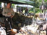 |
В мастерской кузнеца выставлены работы - фонари, подсвечники, петли, приспособления для камина, перила для лестницы, ворота, а также экспонаты 18 века. Посетители могут сами выковать гвоздь. «Проверки» молодых пар у кузнеца. Принимаются заказы. |
|
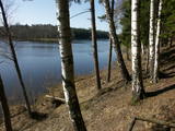 |
Озеро Валгума – протяженностью до 3
км в длину и глубиной 27 м озеро
образовалось в субгляциальной рытвине
(ледниковое).
|
|
 |
Находится в историческом центре Лудзы, откуда открывается красивый вид на храмы города и городище. Готовят латгальские блюда из местных продуктов. Латышская кухня: Серый горох с салом, по-разному приготовленная свинина. Особое блюдо: «Угощение от хозяина» - мясное и куриное филе с сыром и медовым соусом. |
|
 |
Кафе-кондитерская в Кулдиге, где до самого вечера посетителям предлагают свежие кондитерские изделия собственного приготовления. |
|


