
| No | Name | Description |
|---|---|---|
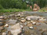 |
The Amata is one of Latvia's swiftest river, and water tourists congregate there each spring to engage in extreme activities. From the Rīga-Veclaicene highway, the Amata flows into a deep valley, with an average drop of more than 3 m/km or, downriver, as much as 8-10 m/km. Water tourists usually use the segment of the river between Melturi and the Zvārte cliff or the Veclauči bridge that spans the Līgatne-Kārļi road. Please remember that the Amata is not a friendly river for beginners. After lengthy rainfall, the river can be navigable during other times of the year, as well. The surrounding valley is attractive because of impressive sandstone and dolomite cliffs, among which the best known are the Vizuļi cliff (which can be the site of beautiful frozen waterfalls in winter), the Ainavu cliff, the Ķaubju cliff, the Dzilna cliff, the Zvārte cliff, and the Lustūzis cliff. Between Melturi and Veclauči, there is the Amata geological trail, which is marked with orange paint on tree trunks. There are three segments to the trail – from Melturi to the Kārļi fish farm, from the fish farm to the Zvārte cliff (both segments can be extreme!), and from the Zvārte cliff to the Veclauči bridge. You can hike the trail at any time except when there is deep snow. The most impressive views will be found when the trees are bare. If you boat down the river, you will not have time to look at or photograph the cliffs, because all of your attention will be focused on the river itself and the obstacles therein. |
|
 |
”Cīruļi” atrodas 5 km attālumā no Rūjienas, Jeru pagastā. Īpašums ir pārmantots no paaudzes paaudzē, īpašniekiem vienojoties kopīgā mīlestībā uz ziediem, dažādu augu audzēšanai pārvēršoties arī par vaļasprieku. Dārzā atrodamas arisēmas, ramondas, magnolijas, knifofijas, rodžersijas, ligularijas, rožainā radiola, ehinācijas un vēl daudz vairāk pazīstamu, skaistu augu. Pavasaris iesākas ar sniegarožu un daudzo sīpolpuķu plaukšanu, vēlāk - krāsainie īrisu ziedi un trauslās astilbju skaras. Daudz skaistuma un krāsainības puķu dobēm piedod heihēras un hostas, kas priecē līdz pat vēlam rudenim. Dārzā aug arī skujeņi, vīteņaugi un katru gadu ražojoši vīnogulāji, kas veido pašu dārza telpu.
|
|
 |
The Kurzeme Peninsula has the largest landscape of hillocks and valleys in Europe in the shoreline segment from Melnsils and Kolka to Oviši and Liepene. It is a unique landscape in Latvia, and part of it is in the Slītere National Park. The Pēterezers Nature Trail offers the best chance to look at the landscape. There are hillocks and valleys elsewhere, too – near shoreline villages where the Kukšupe valley (one of the longest ones – 8 km in all) is crossed by the Ventspils-Kolka highway, as well as near Apakšceļš. The only thing is that you need to learn how to spot the areas out in nature. |
|
 3 days
|
This route section takes you to the Dzūkija National Park – it is among Lithuania’s most forested and desolate nature areas –, and to the town of Druskininkai – a popular SPA and mineral water health resort on the banks of the river Nemunas. When in Druskininkai, we recommend dipping yourself in mineral water baths, enjoying the trip with the cable car over the river Nemunas, visiting the musical fountain, and walking along the river promenade. The starting point of the hiking route is the village of Didžiasalis, which is reached by bus from Druskininkai. From there, the route will take you through vast coniferous forests, rich in berries and mushrooms, and small villages. As you get to Druskininkai, the Forest Trail will meander along the small streets and parks of the historic resort of Druskininkai, crossing the river Ratnyčia and the forest park on the right bank of the Nemunas valley. Leaving the resort town behind, the Forest Trail runs on the side of the village revealing you the beautiful landscapes and the view of the Liškiava monastery on the other bank of the river Nemunas. Up to the village of Žiogeliai, the route goes along forest roads and continues along the banks of the Nemunas valley, surrounded by the vast Dzūkija forests. Towards the end of the route, climb up the Merkinė Mound and it will surprise you with breathtaking views of southern Lithuania. |
|
 |
The farmstead Riveni specializes in fruitgrowing and the products of reprocessing those – dried apples, apple juice. |
|
 10 days
|
Этот тур рассчитан на семейный отдых. В нем культурные и природные достопримечательности сбалансированы с множеством забав для детей. Маршрут включает в себя несколько ферм, где можно понаблюдать за домашними животными и Природные тропы Лигатне, где можно увидеть диких животных. На пути есть несколько средневековых замков и живописных городов. Побережье моря встретит Вас песчаными пляжами и рыбацкими деревушками, где Вы сможете отведать копченой рыбы. Национальные парки Гауя и Слитере предложат Вам несколько природных троп и живописные пейзажи. |
|
 |
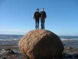
The Boulder of Subinaite can be found in Sakstagala rural municipality opposite Vaļenieku House that
is on the left side of the river Rēzekne. The base of the boulder is below the river level; it is 5,2 m long, 4,4
m wide, it rises about 1,6 m above the water level, about 2,5 m below the water level, capacity 26 m3.
Reddish surface is heavily eroded and full of moss. Protected since 1977.
|
|
 |
At Jūrkalne, there is a small viewing area on the steep shore which offers a magnificent view. At the foot of the shore, which can be accessed via a set of steps, the view is no less wonderful. It is worth hiking along the entire shore from Pāvilosta to Sārnate (approximately 30 kilometres).
|
|
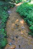 |
The Saltupju sacred stream is 1.3 km to the Northwest of the centre of Aknīste, near the small valley of the Dienvidsusēja River. The stream has been known as a source for medical treatments since antiquity. It is said that streams which flow to the East always have medicinal water, particularly on Easter morning for those who rinse their eyes in it. The water contains iron compounds, which is seen in the brown sediment (the result of iron bacteria). Alongside the stream is a stone with a small indentation, and it is thought to have been a cult stone long ago. A sacred linden tree grows at the edge of the valley. The stream can be seen with good reason as one of the most outstanding streams in all of Latvia. |
|
 |
Origins of Livani as a bigger place of population are linked to the 1533, when the then owner of the land Lieven established the manor and called it after his own name Lievenhof. The 1678, the first Catholic Church was built here. The city suffered considerably during the two world wars. Name of Livani is associated with the glass. In 1887 a glass factory was founded here, which today has ceased operation. |
|
 |
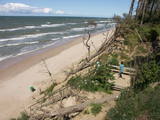
Covered with rocks and with small capes and inlets, this is the eastern shore of the Bay of Rīga and the only place in Latvia where sandstone outcrops are found. These are the result of the abrasive effects of waves between Tūja and Vitrupe. Among the most distinguished of these outcrops are the Veczemi cliffs, which are less than half a kilometre long and up to four metres high. The area has been improved for tourists. It has to be said that this part of the shoreline changes very often, particularly after large storms.
|
|
 |
Хозяин создал специальный комплекс курсов и процедур, которые посвящены здоровому образу жизни. Обучение для групп, массажи, лекции, практические занятия и т.п. |
|
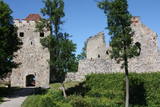 |
Exploring of Sigulda can be started with a visit to Sigulda castle ruins. The construction of the castle was begun by the Knights of the Sword Order in 1207, but in 1236 it was rebuilt for the needs of the Livonian Order. Sigulda castle suffered much from the wars in the second half of the 16th century and in the beginning of 17th century. During the Northern War, it is burned down and is no more restored. Today south-western building of the convent and the tower of the main gate, behind which is the inner forefront of the castle with open air stage, which offers impressive views over the Gauja valley. Currently the reconstruction of castle ruins is in progress. Construction of New castle (owner - Prince Kropotkin) in the South of the Sigulda took place from the 1878 until 1881. From 1923 - 1940 the building was the Palace of Writers, but during the Soviet years - Cardiology sanatorium. Since 2003 Sigulda district council is located there. The manor complex includes wooden house (middle of 19th century), which was Kropotkin's family home, barn (turn of the 18th - 19th century), gardener's house (19th century) and a stone fencing (19th century.) If we make our way from New Castle in a north-eastern direction, after almost 2 km we will reach Vejupite ravine. There you can see the shallow (3.6 m) but high (6.1 m) in Peter's Cave and deep Pucu ravine with Krauklupite. At the conjunction of ravines of both streams rises a Satezele hill fort (plateau 90 x 75 m), where in the beginning of 13th century was the oak castle of Liv land chief (eldest) - Dabrelis. Near can be found Krauklu gorge - ravine of Vejupite left bank, with 11 m high sandstone walls and 5.2 m deep Krauklu cave. At the conjunction of Vejupite ravine and Gauja valley columns Paradise (Gleznotaju) Hill - a very picturesque place, painted and photographed since old times! The Paradise Hill can be reached with a electric vehicle. In the west part of Sigulda is located Ferris wheel (works during the summer) and Air cableway (streetcar) - the only this type of vehicle in Baltics (built in the 1969). Its self-supporting cable extends in 1060 m length and without any support joins the Gauja River valley banks between Sigulda and Krimulda ~ 40 m above Gauja River. Here you can enjoy excellent views! In the south-western part of Sigulda one can walk to mighty Beites precipice, which is split by the deep ravine of stream. On the west side of the ravine lies Keizarskats, which is located ~ 67 m above the Gauja level and offers good views of Krimulda and Turaida castle. Sight place was arranged here already in the 1862 when Russian Tsar Alexander II visited Sigulda. In the eastern part of the ravine wooden Keizarkrēsls (Emperor Stool) is located. |
|
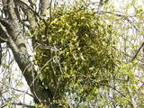 |
This is a mostly forested territory which is home to one of the largest areas of the white mistletoe, which is a semi-parasitic plant. It is best to observe this unique plant when it has no leaves. Latvia is the northern limit to the white mistletoe, which is why it is not all that common. It is interesting that even more of this rare specie can be seen outside of the nature restricted area. |
|
 |
This viewing tower is on a narrow peninsula among Lake Lukna, Lake Višķi, and Lake Boltars. From it, you can see all three lakes, the hillocks of the area, as well as Ambeļi and Višķi. Come here when the bird-cherry trees are in bloom!
|
|
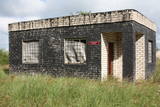 |
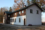
The Lūžņa radio equipment company was part of the Naval Border Guard in Soviet Times. The car park in the centre of Lūžņa offers a fine view of the former military complex. Some buildings are used as apartment buildings at this time.
|
|
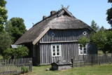 |
Koņuciems of Pape is one of the few seashore fishing villages in Latvia to have preserved an authentic environment to the present day. The Latvian Open-Air Ethnographic Museum has a branch here, “Vītolnieki”, and this is an authentic and ancient fisherman’s farm. +371-2926-2283. The sad fact is that some people have built modern buildings in the village, and it has now lost its earlier untouched charm. |
|
 |
Kaut arī Augštaitijas nacionālo parku uzskata par floristiskā ziņā ļoti bagātu teritoriju, šī ir vienīgā vieta, kur varam iepazīt augu valsts bagātību. To īstenot palīdz takas malās izvietotie informācijas stendi. 3,8 km garās lokveida takas sākums ir meklējams Palūšē, Lūšu (Lūšiai) ezera galējā austrumu punktā. Taka ved gar ezera krastu, mežainām kāpām, nelielu strautu ielejām un pa purvāju. Nenomaldīties palīdz krāsu marķējums uz koku stumbriem. |
|
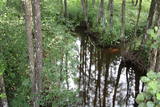 |
This territory is on both sides of the central section of the Raķupe River. On the banks of the river, there are many different meadow habitats, as well as massive oaks growing in the places of former farmsteads which are uninhabited by now. This is an important place for rare plants and animals. There is no tourism infrastructure for visitors in the area. Visitors who are especially interested in the environmental cognition are advised to visit the territory in attendance of experienced local guide. Raķupe is not usable for water tourism because of tilts of trees and beaver dams. |
|
|
|
Latvijai neparastā izskata tornis tika uzcelts līdz ar Ziemeļblāzmas kultūras pils un parka atjaunošanas procesu. No torņa paveras plašs apkārtskats uz jau minēto parku, pili, Daugavu, Pārdaugavu un Daugavas vārtiem (Daugavas ieteka jūrā). Darbojas lifts. Tornis atvērts sezonas laikā. |
|


