
| No | Name | Description |
|---|---|---|
 |
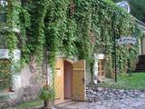
The Cheese hut dates back to 1768 and was once part of the Kalnamuiža (Smiltene) Estate. It is the only object of industrial heritage that is still found in Latvia. On the first floor there was the storage of milk and a set of cheese pots. Stairs to the second floor have been lost. The second floor was used to dry cheese, and the process was facilitated by holes in the walls of the hut so that the wind could help in the process. Although the holes have been filled up, their placement can still be easily seen. The Cheese hut is alongside the ruins of the Medieval castle in Smiltene. Sadly, it is in terrible shape and can only be viewed from the outside. |
|
 |
Žagare has long since been known for a special type of cherries. There are various varieties which only differ in terms of when they are ripe and productive. There are different types of trees. The cherries grow at nearly home, and that is an exclusive symbol of Žagare. |
|
 |
This is a “peripheral” island in the Bay of Finland, 9 km from the Dirhami port. The special fact about this island is that it offers fields of juniper, a rocky and grassy seashore that is around 2 km long, and limestone cliffs that are a few metres high along the northern and the eastern shores of the island. These are designated with the words Osmussaare pank.
|
|
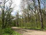 |
One of the few pure stands of oak trees in Latvia, this one covers 19.6 ha, and it was declared to be a protected territory back in 1928. The oldest trees are 300 to 400 years old. The stand of trees can be found alongside the Ezernieki-Andzeļi road. There is a small car park, along with a hiking trail, an information stand, and a leisure area with a plank from which the northern bay and islands of Lake Ežezers can be seen very well. There are typical species of plants, mushrooms and insects here, but only a specialist will be able to recognise them. |
|
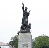 |
Located in the centre of Atbrīvošanas Alley, this statue is a monument to the liberation of Latgale and the unity of Latvia and is officially called “Unified for Latvia.” The bronze monument was unveiled in 1939 (sculptor K. Jansons, designer L. Tomačisks). In 1940, the Soviet regime tried to destroy the monument, but it was restored in August 1943. A second attempt to destroy the monument occurred in June 1950, and this time the process was successful. After the restoration of Latvia’s independence, “Māra of Latgale” was installed for a third time on August 3, 1992, sculpted by the son of K. Jansons, A. Jansons, on the basis of old designs. “Māra of Latgale” is one of the best examples of monumental sculpture in Latvia. Latvian mythology personifies the goddess Māra as a provider of fertility for earth and a protection of life. The cross that is part of the ensemble is a symbol of the Christian faith. |
|
 |
The café is situated in a comfortable cellar of a museum commemorating the life of the Latvian author Anna Brigadere. Here you will find a variety of foods and drinks that can satisfy any taste. In the summer, in the yard filled with sunshine, you will be able to relax on the outdoor terrace, listening to the waterflow of the Tervete river, whereas in winter, having enjoyed the snow drifted landscapes, warm up in the cellar, drinking tasty tea. The café organises parties with the good witches of the Tērvete forest, as well as rides in horse-drawn carts or sleds. Latvian cuisine: Pork ribs in honey sauce, pancakes with jam, mushroom sauce. Special foods: “Bear’s paw”. |
|
 |
Pärnamäe farm on Kihnu Island has won the title of most beautiful home four times. The owner is preparing traditional, home-made dishes, Kihnu bread and smoked fish that you can also buy at Kihnu port market. The accommodation is located in three comfortable cottages. In winter, unique Kihnu carpets are made here |
|
 |
The old narrow-gauge railroad. You can still see the station, the baggage
warehouse, the house where the station commander lived, and the path along
which the little train ran back in the day.
|
|
 |
Atrodas Ganību ielā 120. Celta (iesvētīta 2001. g.) mūsdienu modernās arhitektūras formās un interesanta ar faktu, ka sākotnēji bijusi Vatikāna paviljons Pasaules izstādē “Expo 2000” Hannoverē. To pārbūvēja un uz Liepāju pārcēla par Vācijas katoļu saziedotajiem līdzekļiem. Ēkā darbojas katoļu draudzes centrs. |
|
 |
Pitas ir pēc inovatīvas žāvēšanas tehnoloģijas radītas augļu, ogu un garšaugu garšvielas, kuras ražo mājražotāja Lorita Miķelsone. Mājražotāja labprāt ļaus nodegustēt un iepazīstinās ar Pitām jebkuru interesentu, uzņemot apmeklētājus Skaisto un praktisko ideju dārzā Dobelē. |
|
 |
Atrodas Valmieras – Ainažu autoceļa (P 16) malā starp Matīšiem un Aloju. Iekārtota vecajā un atjaunotajā dzirnavu ēkā. Nedēļas nogalēs piedāvā izklaides pasākumus, klāj galdus un īrē telpas svinībām. |
|
 |
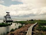
This is the most visually impressive drumlin field in the Baltic States, and it is close to the village of Tabivere. The drumlins were established by ice glaciers, and they point in the direction in which the ice moved long ago. In terms of their appearance, the drumlins resemble loaf-shaped hillocks. From their “backs,” there are lovely views of the local landscape and the lakes that are around the area. The visitor centre is in the village of Äksi.
|
|
 |
The family company in the centre of Trikāta prepares a variety of chocolate delicacies - truffles, chocolates figures. During summer you can buy ice-cream made from the milk and cream of local producers. |
|
 2 days
|
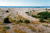
The Baltic Coastal Hiking Route goes through Nõva Nature reserve where you will have exceptional views of the white and grey dunes. The beaches are popular for fishing and kite-surfing. In Dirhami you can spend some time in a cafe and from its terrace you will have a beautiful view of the sea and the port. Along the way you can also see ancient Swedish hamlets with a different cultural environment and landscape, as well as shallow lakes that have been separated from the sea. |
|
 |
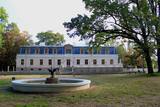
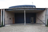
The No. 94 Driving School of the Soviet Navy back in Soviet times now houses the Liepāja No. 3 Elementary School.
|
|
 |
The farm offers educational programmes about the specifics of growing hemp, as well as about hemp products. During the programme, visitors are treated to products grown at the farm. |
|
 |
Vieta Suvalkijā ģimenes svinībām un atpūtai laukos. Atjaunotajā ar vēsturi saimniecībā atradīsiet etnogrāfisku un modernu interjeru elementu sajaukumu. Plaša dzīvojamā istaba ar kamīnu, oriģinālas ozolkoka mēbeles, guļamistabas ar visām ērtībām un virtuvi. Lauku pirts un kubls. Mežs pie mājas bagāts ar sēnēm un ogām. Piedāvājumā izglītojošas aktivitātes, stafetes bērniem un viņu vecākiem līksmībai, pirtnieka pakalpojumi.
|
|
 3 days
|
This three-day tour offers a variety of culinary experiences. A bus tour is combined with cycling on Kihnu Island to visit local farms and production facilities making unique foods from local ingredients. You will taste cider, fish, herbal teas, beer, dairy products, and pastries. You will visit traditional Estonian and Russian households to enjoy real home-made meals and experience local culinary heritage. |
|
 |
Engures apkaimē aug 22 no Latvijā sastopamajām 32 orhideju dzimtas sugām .Lai dabas parka apmeklētājiem dotu iespēju aplūkot šīs interesantās augu sugas, ierīkota Orhideju taka. Kopējais takas garums ir 3.5 km, tā sākas netālu no Engures Ornitoloģisko pētījumu centra, līkumo caur kalcifilajiem purviem un mežam putnu novērošanas torņa virzienā, un aizvijas tālāk gar atjaunoto ezera piekrastes pļavu, kurā mīt govis un zirgi. Takas sākumā novietotajā informācijas zīmē attēlotas ne tikai apkārtnē sastopamās orhidejas. Tur iespējams gūt daudzpusīgu informāciju arī par citām interesantām Engures ezera dabas parka augu sugām.
|
|
 |
The Karosta prison cannot be described, it must be experienced and survived. That’s an opportunity for everyone. This is the best example in Latvia as to how the military heritage can be used for tourism purposes. Others can learn from this site. |
|


