
| No | Name | Description |
|---|---|---|
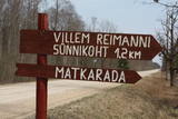 |
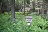
Kultūrvēsturiska taka (garums ~ 2 km) Tipu (Tipu) ciemā, kas iepazīstina ar vairākiem interesantiem objektiem: veco skolu (1931. g.), Hallistes upi, pirti un Paunas saimniecību, kurā dzimis viens no Igaunijas nacionālās kustības līderiem Villems Reimans (1861. – 1917.). |
|
 |
Laila Kelle works in a building of the former Lamiņi semi-estate. She teaches drawing and painting of landscapes and still life paintings, using oil paints for this purpose. Nature trail (3km).
|
|
 |
Nature restricted area is located to the South from former railroad Ventspils-Liepaja and includes approximately 6 km of Uzava River (and the old drainage system). The territory was used for agriculture during Soviet time, now it starts overgrow by scrubs. The protected nature values – rare bird species, including corncrakes, variety of grassland habitats and plant species. Territory is not useable for tourism activities. There is a possibility to get good insight into the North part of restricted area from the road Alsunga – Berzkalns where information stand is located.
|
|
 |
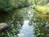
Līčiem, pussalām un salām bagāts ezers ar izrobotu krasta līniju, kas savienots ar Zvejnieku un tālāk - citiem Latgales augstienes ezeriem. Ozolu un platlapju meži, kas aug uz ezera salām un pussalās ir ne tikai aizsargājami, bet arī Latvijas mērogā nozīmīgi biotopi. Tiesa, to vērtību apzināsies tikai vides speciālisti. No Jašas ezera var uzsākt laivu braucienu pa vienu no Latgales ezeru "kēdēm". Ezera austrumu krastā atrodas Geļenovas parks.
|
|
 |
The farmstead "Vitolini" specializes in horse breeding, as well as horse-riding lessons. It is possible to go horse-riding in the forest or to take a ride in a horse team. |
|
 |
The museum set up in 1982 presents life and activity of the region from the late 19th C to the recent past. Temporary exhibitions are held in the barn and more than 200 species of trees and shrubs can be viewed in the parkland extending over 17 ha. Themed events include baking bread, celebrations of folk holidays are frequently arranged. From the museum visitors can access Velise cultural and natural heritage trail. |
|
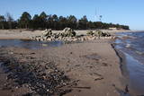 |
This is the most distinct cape in Latvia, with the waves of the Baltic Sea and the Bay of Rīga coming together. During storms, the waves can be as much as 7 metres high. The cape is an underwater shoal that stretches to the Kolka lighthouse, which is 5 km away. It is on an artificial island that was created between 1872 and 1875. When the island became stable, the 21 m lighthouse was installed in 1883. Manufactured in St Petersburg, the lighthouse became operational on July 1, 1884. Today the island contains the building for the supervisor of the lighthouse, several ancillary buildings and an impressive fog bell. A monument to men lost at sea that was sculpted by Ģirts Burvis is on Cape Kolka, as is a wrecked wooden ship, presumably from the 19th century. There is also a rock that is known as the “heart of Europe,” because the Latvian folklorist Krišjānis Valdemārs believed that the cape was the centre of Europe. There are stands with information about Valdemārs, and the Latvian Border Guard uses facilities that were once in the hands of the Soviet Coast Guard. Cape Kolka is an important place for migrating birds during the season, and it has a visitor centre and a summer café. There are unusual pines on the beach that were washed onto it during storms. Under the water around the cape is the largest ship graveyard in the Baltic Sea. It is a dangerous place for swimmers because of changes in the flow of water and shifting sands. At the end of the cape are the ruins of an old lighthouse that was built in the 18th century and lost during the latter half of the 19th century. |
|
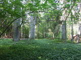 |
This is a fairly unique territory in Latvia – a vast forest of oak trees (many of them very large, indeed), linden trees, elms and various other deciduous trees. In the company of a forest guide, the visitor can walk through a small part of the forest, learning about the inhabitants of the area and their importance. This is an environmentally protected zone.
|
|
 |
This pyramid-shaped hillock with an observation tower at the top of it was established by the Soviet military. It is along the Ķevele-Saldus road, where the Zvārde airfield used to be located. It was used as an observation facility to co-ordinate army training manoeuvres. There is a view of the former airfield and the massive forests of the Zvārde Nature Park and nature reserve. It is an appropriate location for bird-watching. Note that there are no improvements there.
|
|
 |
The town of Subate was first listed in documents in 1570, when Duke Gotthard Kettler of the Duchy of Courland sold the Subāte marketplace to Count G. Plater-Sieberg. When the Plater-Sieberg dynasty converted to Catholicism in the mid-17th century, Lutherans in Subate protested by moving to the eastern bank of Lake Subate. That was the property of the Prode Estate (only ruins remain at this time), which was owned by the Osten-Sacken dynasty. In 1685, the Osten-Sackens built a Lutheran church for the “refugees,” and Jaunsubate was established around it. Both parts of the town were merged again in 1894. During Latvia’s liberation battles in 1919, Subate was liberated by Lithuanians, at which time the town was divided up between Latvia and Lithuania (though the border between the two countries was set at the previous line in 1921). The historical centre of Subate was established between the 16th and the 19th century, and it includes four churches for various congregations and low wooden buildings which stretch along narrow and curvy streets. The town is on the shores of a sub-glacial depression with Great Lake Subate and Lesser Lake Subate therein. This provides the town with unusual landscapes for Latvia. |
|
|
|
Viens no raksturīgiem karsta parādību piemēriem, kur nelielas upītes - strauta ūdeņi pazūd vairākos ūdensrijējos un pēc kāda brīža - iespaidīgās Lauces ielejas krastos iznāk spēcīgu avotu veidā, tālāk ieplūzdami Lauces upē. Šī parādība dinamikā vislabāk ir novērojama pēc lietavām vai pavasaros sniega kušanas laikā un kādu brīdi pēc tam. |
|
 |
This territory protects a lime outcrop found on the shores of the lower reaches of the Zaņa River. There is a path for active hikers which begins at the Zaņa mill (1864, rebuilt 1890, shut down 1960). The path weaves its way along the steep shores of the little river, heading toward its mouth.
|
|
 |
Contact her in advance, and the landlady here will bake various cakes, pastries, carrot buns and pierogi with various fillings. You can also order smoked fish. |
|
 |
The brewery is located in Upespils, Suntaži parish, Ogre district. IndieJānis Brewery is one person's foolishness, longing for life and cheerfulness, which is why the owner's main goal when brewing is to create a certain taste, regardless of the cost of the product. Beer can be purchased locally in brewery by prior contact, as well as in pubs - TAKA, Brevings, Zobens un Lemess, Vinilbārs, Alus Muiža, Miezis un kompānija, Valmiermuižas alus vēstniecība. |
|
 |
Ja apskatīta kodolraķešu bāze, tad var iziet 3,2 km garo Ploštines izziņas taku, kas sākas turpat netālu. Taka ved cauri dažādiem mežu tipiem, iepazīstinot ar sikspārņu būrīšiem (cilvēka radītas sikspārņu dzīves vietas), apkaimes augiem un putniem, kā arī aizsargājamu dabas pieminekli – Pileļu avotu (Pilelio šaltinis). |
|
|
|
The viewing tower is on the western part of the Blue Hills of Ogre, not far from the Dubkalni quarry. Paths lead to the tower, as does a wooden staircase. The viewing platform offers a very broad view of the Ķegums hydroelectric power plant reservoir and the towers of
|
|
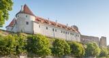 |
One of the most important military and political elements of the Livonian Order, the Bauska Castle was built between 1443 and 1456 at the place where the Mūsa and Mēmele rivers flow together. The castle had five towers and walls that were up to three metres thick. Between 1580 and 1596, the forecastle was replaced with a residence for the duke of Courland, and its walls were finished with the sgrafito technique. The castle suffered damage during wars in the 16th and 17th century, but it was always restored until 1706, when the Russian military blew it up during the Great Northern War. Today the castle houses a museum, with a viewing platform in its south-eastern tower. |
|
 |
2012. gadā tika izveidots ģimenes uzņēmums "Bioorganic earthworm compost", kurš nodarbojas ar organiskā mēslojuma - sliekkomposta jeb biohumusa ražošanu. Ir izveidota moderna sliekkomposta ražotne, kura ir viena no lielākajām Baltijas valstīs. Pieaugot cilvēku interesei par zaļo saimniekošanu un iespējami kvalitatīvāku ekoproduktu iegūšanas iespējām, tiek piedāvātas ekskursijas pa ražotni, lai parādītu, kā tiek ražots viens no visefektīvākajiem organiskajiem mēslojumiem - sliekkomposts. |
|
 |
Atrodas Tirgoņu un Zāļu ielas krustojumā (Zāļu ielā 12). Interesanta ar faktu, ka šī ir vienīgā padomju laikā uzbūvētā (1948. g., pēc citiem avotiem – šajā gadā atjaunota) Latvijas baznīca. |
|
 |
Antons Rancans produces wooden busts of well known people from politics, the arts and other fields of endeavour, and these can be purchased. Visitors can also commission decorative objects that are produced from wood. The artist also produces crucifixes. Gundega Rancāne is a landscape painter who is renowned for her masterful use of light and shadow. Her works are available for purchase.
|
|


