
| No | Name | Description |
|---|---|---|
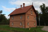 |
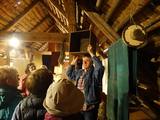
Vijciema čiekurkalte ir viena no retajām vēsturiskajām čiekurkaltēm Eiropā, kas celta 19. gadsimtā, un ir ne vien teicami saglabājusies līdz mūsdienām, bet arī, izmantojot vairāk nekā 100 gadus senas iekārtas, čiekurkaltē arvien tiek žāvēti čiekuri, lai iegūtu augstas kvalitātes meža sēklas. Pateicoties ēkas bagātajai vēsturei un senajām čiekuru žāvēšanas tradīcijām, Vijciema čiekurkalte ir iecienīts tūristu objekts, kas piesaista vēstures, dabas un tehnoloģiju interesentus. Vijciema čiekurkaltes apmeklētājiem ir iespēja doties izzinošā ekskursijā gan individuāli, gan grupās. Ekskursijas laikā ir iespēja atklāt čiekurkaltes vēsturi, skatīt čiekuru apstrādes cikla demonstrāciju, kā arī uzzināt, kur, kā un kāpēc čiekuri tiek lasīti. Ekskursijas un individuālos apmeklējumus iepriekš jāpiesaka, zvanot 26478620. Cena
|
|
 |
Iespēja iepazīties ar savvaļā augošiem un kultivētiem ārstniecības augiem, pašiem tos ievākt, izbaudot Latgales neskarto dabu, sasiet ārstniecības augu slotiņu veselībai un pirtij. Nodegustēt augu tējas lauku klusumā vai tieši otrādi - kopā ar „Muzikantu ciema” muzikantiem, piedaloties jautrās aktivitātēs, iepazīties ar bagāto latgaliešu tautas dziesmu un polku pūru. |
|
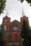 |
Dievnams celts no šķeltajiem laukakmeņiem un sarkanajiem ķieģeļiem laikā no 1894. - 1909. g. Tajā saglabājušās vecās koka baznīcas iekārtas un 18. gs. sākumā veidots cilnis “Svētais vakarēdiens”. |
|
 |
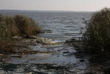
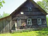
On the right bank of the River Pēterupe is one of the historical areas of Saulkrasti – Pēterupe Village. It is believed that the village began to form around a chapel during the so-called Swedish or Catholic times. The chapel was named after the Apostle St. Peter, and therefore the river and the village also carries his name. Pēterupe Village can be considered the oldest village in the Saulkrasti region. The oldest witnesses of the origin of Pēterupe Village are: Rectory, Pēterupe Evangelical Lutheran Church, Outpatient Clinic and the wooden buildings in the old village centre. |
|
 |
Radošajā mājā Latvietes pūrs var apgūt praktiskās iemaņas rokdarbu veidos, kas nepieciesami latviešu tautas tērpu darināšanai – baltie un krāsainie darbi, zīļu vainagu darināšana, adīšana, tamborēšana, tilla izšuvumi, pīto un austo jostu darināšana u.c. Saimniece pati pārzina dažādus rokdarbu veidus un to tehnikas, nepieciešamības gadījumā tiek pieaicināti sava aroda meistari. Ir zināšanas par latviešu tautas tērpa novadu īpatnībām, saimniece labi zina tautas tērpu attīstības vēsturi un pielietojumu
|
|
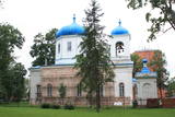 |
Atrodas pilsētas centrā, Atbrīvošanas alejā 98. Dievnamu sāka celt 1840. g. (iesvētīja 1846. g.) un tas uzskatāms par pilsētas vecāko sakrālo būvi. Nekvalitatīvu būvniecības materiālu izmantošana un cēlāju pieredzes trūkums bija iemesls, kādēļ 1854. g. to nācās pārbūvēt. Pie baznīcas atrodas 1867. g. būvēta Sv. A. Ņevska kapliča, kas veltīta cara Aleksandra II paglābšanās faktam vilciena katastrofā un stikla mauzolejs, kurā apbedīts baznīcas mecenāts ģenerālis Karaulovs (šobrīd tiek restaurēts). Dievnams ir atvērts arī apmeklētājiem. |
|
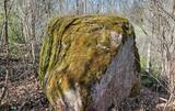 |
The Boulder of Labvārži is located in the Northern side of Adamova Nature Park, in the SW of Lake
Vizulītis (Labvārži). It is located 0,70 km from the Labvārži or Laboržu House. The boulder is 5.9m long and
4,0 m wide.
|
|
 |
This is the 11th largest Estonian island, and its central section is covered by a broadleaf forest (linden, oak, elm and other trees) that is more than 100 years old. Along the shores, the Abruka Island has meadows and small areas of wetlands. Only the northern part of the island is populated. Few tourists come to call, which means that the island is relatively untouched by humankind.
|
|
 |
The air defence radar facilities at the Liepāja airport in Cimdenieki are gone now, although the man-made terrain in the area remains interesting today.
|
|
 |
This is the widest water fall in Latvia – 249 metres wide and up to 1.75 metres high. This is an interesting natural, cultural and historical object in that it is linked to various events and legends. Duke Jacob of Courland invented equipment to catch fish. It was fastened to the cliffs of the waterfall, and this created the tale of a city where salmon and other fish who were leaping across the waterfall fell into the nets and were thus caught in the air. During Jacob’s rule, there was talk about digging a canal around the waterfall to ensure shipping, and work began on the project. During the early 18th century there was the idea that the Baltic Sea and the Black Sea could be connected via the Venta, Nemuna and Dnieper rivers. Turkish prisoners of war continued to dig the canal, but the local dolomite cliffs were a problem. Attempts to blow up the cliffs led to damage to nearby buildings, so the work ended. The impressive ditch can still be seen today. In 2012, a wooden pathway was installed on the right bank of the Venta to offer a good look at the waterfall. It is worth visiting here during various seasons of the year, when different types of fish migrate. |
|
 |
Atrodas Amatas ielejas augstajā krastā, autoceļa (A 2) Rīga – Veclaicene malā. Plašs ēdienu klāsts, lielas porcijas, iecienīta tālbraucēju šoferu maltītes ieturēšanas vieta. |
|
 |
Das beinah 100 km langes und bis zu 36 km breites aus dem Süßwasser bestehende Haff, das im Norden mit der Ostsee verbunden ist. Das Haff trennt vom Merr die eindrucksvolle Kurische Nehrung. Ins Kurische Haff mündet der größte Fluss Litauens Nemunas ein. |
|
 |
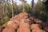
The museum at Egļava has an exhibition about forestry in Latvia before and after World War II. The exhibit features forestry tools and equipment, as well as textiles from the former Balvi District along with samples of ceramics and woodworking. The former forest ranger house has rooms to provide accommodations to guests. |
|
 |
Atrodas Rīgas – Ventspils autoceļa (A 10) 92. kilometrā. Piedāvā ēdināšanas pakalpojumus, klāj galdus un organizē citus pasākumus. |
|
 |
Naissaar is a small island near Tallinn which was exclusively used by the Soviet military from 1945 to 1993. Attractions on the island include walking trails, varied habitats, a narrow-gauge railway, fortifications from the early 20th C, and a Soviet naval mines factory. |
|
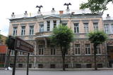 |
Atrodas Rīgas ielā 8 – skaistā, 1883. g. celtā jūgendstila ēkā . Muzejs (viens no Latgales lielākajiem un vecākajiem) tajā darbojas no 1959. g. (pats muzejs dibināts 1938. g.) un tā krājums vēsta par Daugavpils un tās apkārtnes vēsturiskajiem notikumiem. Tajā regulāri tiek rīkotas arī tematiskās izstādes, piedāvātas muzejpedagoģiskas programmas. Te vēl var apskatīt Daugavpilī dzimušā un pasaulē pazīstamā mākslinieka Marka Rotko (1903. – 1970.) gleznu reprodukcijas, kuras no 2013. gada plānots pārcelt uz M. Rotko centru Daugavpils cietoksnī. |
|
 |
This nature park protects the landscapes of the Latgale highlands. Of importance here are Lake Ruskulis and Lake Cīrītis with its eight islands, along with the forests of the area. An ancient castle hill is on one of the islands in Lake Cīrītis – the Upursala island. There and on the Oši island, specialists have found more than 250 species of plants. |
|
 |
The House-Museum of the writer Michael Narics. Reveal the history of political repressions in the
USSR and Soviet Latvia; see creative works of the winners of competition organized by M. Narics Educational
Center.
Working hours: on request |
|
 |
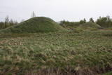
Atrodas Vārtājas ielejas labajā krastā un labi saskatāms no Priekules – Grobiņas (P106) ceļa. Senās kuršu zemes – Piemares pilskalns, kas vēstures avotos pirmo reizi minēts 1253. gadā – līgumā starp Kurzemes bīskapu un Livonijas ordeni. Viens no lielākajiem Dienvidkurzemes pilskalniem. Iespējams, ka iepriekš – arī sens kulta kalns. Pagājušā gadsimta sešdesmitajos gados veiktajos arheoloģiskajos izrakumos konstatēts, ka pilskalns bijis apdzīvots jau vidējā dzelzs laikmetā. Pie tā konstatēta liela senspilsētas vieta. |
|
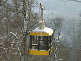 |
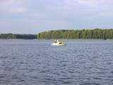
The aerial tram across the Gauja is the only vehicle of its type in the Baltic States. It was installed in 1969 with the help of engineers from Georgia. The crossing is 1060 m long, and the cable which crosses the river is just one cable without any supports. The tram rides about 40 metres above the river, and it offers an outstanding look at the local landscapes. During the evening, the tram is used by Bungee jumpers. |
|


