
| No | Name | Description |
|---|---|---|
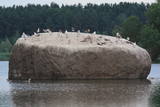 |
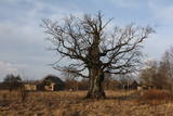
The Radžu stone is located to the South of Jēkabpils and at the north-eastern part of the Radžu sand and gravel quarry (the Radžu reservoir). The stone is the second largest rock in Latvia with a size of nearly 100 m3. At one edge of the quarry is the Jēkabpils Forest Park, which is popular among residents and their guests for leisure, hiking and sports. The beach of the reservoir was granted the Blue Flag in 2012. |
|
 |
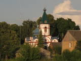
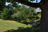
The complex is on the northern shore of Latvia’s second-largest lake, Lake Rāzna. The windows of the “Kastānis” café offer a view of one of the loveliest lakes in the country. |
|
 |
This is an urban construction monument that was created between the 17th and 19th century, and it is of national importance. The street layout around Jelgavas and Rātūža streets forms closed blocks of buildings. There are Lutheran, Catholic, Orthodox and Baptist churches in Jaunjelgava. One of the most outstanding architectural monuments is City Hall, which was built in 1912 and features Art Nouveau forms. None of the city’s five synagogues has survived. The historical centre of Jaunjelgava features a promenade that runs along the banks of the Daugava River. This is a popular place for strolls, leisure and swimming. |
|
 |
Also known as Lake Jēsis or Lake Iesis, this is the lake in Latvia which has the largest number of islands. Many literary sources and encyclopaedias in the 20th century claimed that there were 69 islands in the lake, but that was an exaggeration, because apparently the authors took sandbars overgrown with reeds and other plants to be islands. The true number is approximately two times lesser. The largest number of islands can be found in the north-eastern part of the lake. The largest one is Lielā Lāča (Big Bear) Island (45 ha). A farm was on the island at one time. The islands and the oak trees that are on the shores of the lake – the Piļoru and Pahatnīku stands of trees – are in a restricted environmental reserve. |
|
 11 days
|
On this tour there are the finest cultural and historical heritage left behind over the course of several centuries – medieval castles, different manors and splendid palaces. Part of the route goes through Gauja National Park with some excellent views of meadows and ancient forest, where farmsteads carry on with their unchanging lives. A picturesque road connects three castles - Sigulda, Turaida and Krimulda - situated on the high valley sides of the Gauja river. Further on, the road passes one of the oldest churches in Latvia and heads to two attractive 19th century manors at Birini and Igate. Next day, relax in luxury at Dikļi manor hotel. The tour then goes through charming medieval town Cesis with mighty castle ruins and a newer castle alomgside. The other part of the tour makes a loop formed by Zemgale's distinctive castles and palaces. It includes Jaunpils Castle, barely changed since medieval times, Dobele Castle ruins and Tervete ancient hillock. Located a short ride from each other are 15th century Bauska Castle, strategically situated between two rivers, the classically styled Mežotne Palace hotel and the most famous pearl in the Baltics - splendid baroque and rococo style Rundāle Palace surrounded by a French park. |
|
 |
Pie Melekiem sākas dabas lieguma teritorija. Meleku
krastmala būtiski mainījās 2005. g. orkāna laikā.
|
|
 |
This restricted area is on the eastern shore of Lake Ķīšezers, and of the greatest importance here are the habitats – flood-land and other meadows, dunes, the aquatorium of Lake Ķīšezers, the shoreline, forests of oak, black alder and other trees, and many huge oak trees in the restricted area and beyond its borders. The Bulduri castle hill, which is the most distinct ancient castle hill in Rīga, is on the southern end of the Lieupsala peninsula. On the border of the restricted area is an affiliate of the Latvian Open-Air Ethnographic Museum, which is known as “Vārnas”.
|
|
 |
The Krimulda Lutheran church is seen as one of the oldest in Latvia. It was built in the early 13th century, soon after the territory of Kubasele was conquered. Over the subsequent centuries, it has been rebuilt many times. Alongside the church is a meditation maze called "Lily Blossom." When the Liv warrior Kaupo fell in battle near Vīlande in 1217, his remains were supposedly interred at the church. Local residents, true, describe a small hillock that is near the church as the grave of Kaupo. The site is located alongside the little Runtiņupīte (Runtiņš) river, on the right bank of which is a manmade cave that is approximately seven metres deep. It is the Kubesele Cave or the Runtiņala Cave. The Kubesele castle hill is on the left bank of the Runtiņupīte. The Kubesele Nature Trail starts at the church. If you hike down the trail, you'll see all of the aforementioned objects and others. The trail leads to the Gauja River where, on the right bank, is the Great (Runtiņš) Rock. Nearby you'll find anchor blocks installed by rafters on the river. |
|
 |
Located on the left bank of the Venta River 100 m to the Northwest of the Liepāja (A9) highway bridge across the river. The antique castle hill was the site of a Livonian Order that existed from the 14th to the 18th century before being sacked during the Great Northern War. No part of the castle has survived. A stage was built on the castle hill in 1987, and it is a popular venue for various events. The hill is surrounded by a park with wooden chairs that were designed by the sculptor Ģirts Burvis in honour of the kings of Courland. There is a viewing platform, and there are legends about underground passages and a white lady who appears only once every 100 years. |
|
 |
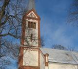
The church was built between 1932 and 1938 to replace an old Neo-Gothic wooden church. It was designed by J. Cīrulis. Until 1994, the building housed a venue that rented out films. Today it houses an exhibition, “From Foundations to the Steeple: Photographs of Ancient Lettigalian Construction Jobs.” This documents the construction of the church. The 37 metre steeple offers a good look at Rēzekne. |
|
 |
It lies between Pīlādžu street and the left bank of the river Siliņupe. In the 3rd to 2nd millenium B.C., there was a fishermen and hunters' settlement in the place of which there is installed an informational commemorational stone (Sculptor O.Skarainis). The settlement near the river Siliņupe is the oldest known human settlement in the area of the Ķemeri National Park. There are found many artifacts: pottery fragments and arrow tips, flint and amber pieces, etc..It is possible that the adjacent residential area has been the place of a cemetery. A small portion of the finds is displayed at the Lapmežciems Museum, the other ones are located in the National History Museum of Latvia. |
|
 |
This is a comparatively large lake (3 km long and 1.3 km wide). It is shallow (no more than 1.1 m deep) and is classified as a seashore lake. The Vecslocene River flows through it. At the southern end, there is a narrow stream which connects Lake Sloka with Aklo Lake – a shallow and small lake with a dolomite bed at some locations. The best view of Lake Sloka can be seen from the bird watching tower on its north-western shore. This is the only floating bird watching tower in Latvia. Alongside it is the beginning of the 3 km Lake Sloka hiking trail, which passes through the flooded wetlands of the lower reaches of the Vēršupīte. An information stand can be found on the shore of Lake Sloka by the car park. Beyond it is a sulphurous spring. |
|
 |
A small settlement with a school, library and shop. North from the Vidale are visible remains of the windmill. Going towards the Gulf of Riga, the road crosses Shlitere Zilie mountain precipice with spectacular views during late autumn, early spring and winter, when there are no leaves on the trees and sandstone outcrops. To the left you can see Zilie mountain spring - a landscaped water taking place. Road that runs from the Vidale to Melnsils side, is called by the locals Knipeldambi. They say that it was built by the German army first During World War I, putting logs on the road and covering them with sand. |
|
 |
Bārbeles sēravots tiek dēvēts par vienu no pirmajām kūrvietām Latvijā, proti, jau ap 1650. gadu hercoga Jēkaba valdīšanas laikā sēravota tuvumā uzbūvēta vannu māja, dēvēta par mazo ūdensdziednīcu, kuru vēlāk arī apmeklējuši visi Kurzemes-Zemgales hercogi. 1739. gadā Rīgas garnizona ārsts Benjamins Teofils Grofs uz Bārbeles sēravotu nosūtījs 10 ievainotus un smagi slimus karavīrus, kas sirguši ar dažādām kaitēm - pēc Bārbeles sēravota vannām karavīri atveseļojušies. Avota ūdeni izmantojuši gan apkārtējie zemnieki, gan muižnieki, gan augstmaņi no Jelgavas. Avotā slimnieki peldējušies, aptriepušies ar dūņām, no tā sagatavotas arī siltās vannas. Tāpat ūdens tika izmantots iekšķīgai lietošanai. Bārbeles sēravots dziedinājis ne tikai skorbutu, locītavu un krustu sāpes, artrītu, pietūkumu, bet arī venēriskās slimības-sifilisu, nervu kaites un daudzas citas slimības. 19. gs. avota ūdenī samazinājās sērūdeņraža koncentrācija. Neskatoties uz to, 20. gs. 20. gados šeit vēl aizvien darbojās vannu māja, tika uzbūvēts arī neliels vasarnīcu rajons, ierīkots deju laukums un parks, kūrorts tolaik tika plaši apmeklēts. Diemžēl, kūrorta noriets seko pēc Otrā Pasaules kara, kad to noposta un vairs neatjauno. Šobrīd par savulaik tik ļoti apmeklēto un nozīmīgo kūrvietu, dēvētu par pirmo kūrortu Latvijā, var tikai iztēloties. Atrodoties pie sēravota, tā laika liecības iezīmējas pēdējās vannu mājas ēkas pamatu drupās, stalti liecinieki arī koki – glabājot sevī savulaik pieredzēto. Sēravota apkārtnē ierīkota atpūtas vieta, informatīvs stends, kurā var aplūkot senākas fotogrāfijas un detalizētāk iepazīties ar kūrorta vēsturi. Tāpat ierīkota laipa, no kuras apmeklētāji var pasmelt avota ūdeni. |
|
 |
Here you will learn about the history and cultural heritage of the Liv people of Vidzeme. Tour the museum and enjoy once characteristic foods from the region – special porridge and a strong alcoholic beverage brewed in accordance with ancient recipes. If your group wishes to do so, it can take part in the baking of rye bread in a true country oven. |
|
 |
Ilze Kupča bakes cakes in Mārupe, preserving her grandmother’s traditions. She has received several awards in various competitions in Latvia. She makes cakes and zephirs from natural products, which are either purchased from Latvian farmers or home producers, grown by herself, or even picked in the forests. Individual orders are accepted. Rye delicacies: blackcurrant and apple zephirs with rye breadcrumbs, lingonberry and caramel cake with rye bread. |
|
 |
In Dagda, on the side of Daugavpils Street, there is a forested hillock that is the Lubāne castle hill. On the upper part of its southern side, there’s a viewing area which offers a view of the small Lake Lubenenis, the eastern part of Dagda, and the white tower of the local Catholic church. Legend has it that treasure is buried here.
|
|
 |
Karņicka kalns pēc savas izcelsmes nav kalns, bet gan Daugavas ielejas nogāzes daļa ar labu skatu uz Krāslavas mazstāvu koka apbūvi. Ar šo vietu saistīts traģisks nostāsts par poļu virsnieka Josifa Karņicka un grāfa Plātera meitas mīlestību, kurai nebija lemts piepildīties tā laika „paražu” dēļ. Tā rezultātā abi nelaimīgie nolemj izdarīt pašnāvību. Virsnieks nošaujas, bet Emīliju pēdējā brīdī izglābj kalpone, neļaujot tai izlēkt pa pils logu. J. Karņicka pašnāvības vietā ir uzstādīts piemineklis. Nedaudz tālāk – rietumu virzienā guļ t.s. Austriņa akmens, pie kura 1909. gadā iedvesmojies un radījis latviešu rakstnieks Antons Austriņš. |
|
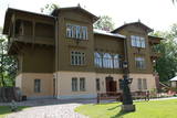 |
On the banks of the Venta River is a treasure of wooden architecture – the so-called Bangerts Villa, which relates to romantic stories and legends and was recently restored. It is said that a man known as Captain Bangerts bought the villa as a gift to present to his Parisian bride. The Kuldīga Administrative District Museum has been in the building since 1940. Since reconstruction, unique wall paintings and other interior design details have been restored, and the flat of the Bangerts family allows people to see how wealthy residents of the city lived in the early 20th century. Also on display are some of the sets of playing cards that have been collected by Jānis Mētra. |
|
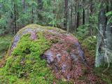 |
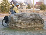
The Grandboulder of Komultēni is situated in Sakstagals rural municipality in the forests; around 700
m from Jēkabpils – Rezekne road to the NE of Komultēni. The flat top and the sides are cracked. Boulder consists
of the magmatized gneiss. The circuit of the boulder is 15 m, length 5 m, width 3 m, height 1.8 m,
capacity about 20 m3.
|
|


