
| No | Name | Description |
|---|---|---|
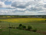 |
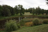
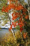
From the Asote castle hill, which is on the right bank of the Daugava River near Jēkabpils, there is a fine view of the Daugava River valley, the Ābeles Island, and the Kaupre castle hill that is at the northern end of the island.
|
|
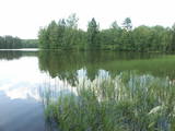 |
Viens no dažiem Latvijas dzidrūdens ezeriem. Apskatāms no Lubānas - Ļaudonas ceļa malas pie Visagala. Lai saudzētu šo ezeru, tajā esošos aizsargājamos biotopus un sugas, ūdenstilpē nevajadzētu peldēties lielām cilvēku masām un pieļaut cilvēka darbības produktu nonākšanu ezerā.
|
|
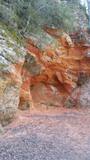 |
Sarkanās klintis savu vārdu ieguvušas pateicoties sarkanajiem iežiem. Tieši sarkanā ir mīlestības krāsa, tāpēc sarkanās klintis ir romatiska pastaigas vieta mīlniekiem. Smilšakmens klintīs redzamas plaisas, kas sašķeļ sarkanīgos iežus, radot neparastu dabas mākslas darbu. To virsma ir diezgan izrobota, kas veido klintīs nelielas alas un nišas. Sarkanajās klintīs ir arī daudz dažādu avotiņu. Pazīstamākais no tiem ir Rūcamavots. Tam ir šāds nosaukums, jo tas, nākot ārā no zemes, izdod nelielu rūkoņu. |
|
 |
Atrodas ~ 0,4 km no Latvijas – Lietuvas robežas, Sventājas ielejas labā krasta nogāzē. Atrodama informācija, ka avotu tīrot, atklājusies 5 x 5 m ozolkoka „grīda”. Avots ir labiekārtots – virs tā slejas lapene ar niedru jumtu. Vēl pavisam nesen pie tā auga Latvijas dižākā ieva (nolūza), kuras vietā tagad kuplo biezs atvašu pulks. |
|
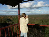 |
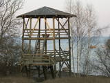
The viewing tower is in the southern part of the reserve, along the Ļaudona-Mārciena road and on the Madona-Trepe embankment. Here you can view a very wide territory all the way to the Vidzeme highlands, including Gaiziņkalns Hill if the weather is clear. At the foot of the tower you will see the lakes known as Small and Great Lake Plencis. |
|
 |
Dundagas pili ieskauj parks, kura pirmsākumi ir meklējami jau 17. gs. Tam cauri tek Pāces upīte, kuras uzdambējums veido Dundagas dīķi. Tajā atrodas senatnē (vēl pirms pils būvniecības) mākslīgi veidota sala - Kalnadārza pilskalns. Tam iepretim (dīķa austrumu krastā) atrodas Dundagas pilskalns. Parkā joprojām zaļo (daži lielākie zari ir nolūzuši) t.s. “Rubļa ozols”, kura attēls bija uz 1919. g. izdotās Latvijas simts rubļu naudaszīmes. Parkā uzcelta estrāde. |
|
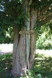 |
This is the thickest and tallest common ivy in Latvia. It is in the park of the Zentene Estate, opposite the mansion (which is now a school).
|
|
 |
At the estuary of the Inčupe River, there is the White Dune, which is around 18 metres high and is the most lovely element of the Vidzeme shoreline among those that have been created by the wind, sand and sea. There is a wooden footpath (the Saulriets trail) which is meant to view, but also protect the dune. It has a viewing area, too. The territory to the south of the river is in the Piejūra Nature Park.
|
|
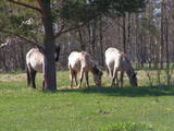 |
Für den Zweck der Bewirtschaftung der Niederungsauen des Pape-Sees und der Vermehrung der biologischen Vielfalt sind hier Konik-Wildpferde angesiedelt wurden. Die kann man mit einem örtlichen Guide kennenlernen. |
|
 |
This area protects the landscape of the Lielauce hillocks, which are a part of the Eastern Kurzeme highlands. Lake Zebrus and Lake Svēte are in this territory. On the north-eastern shore of Lake Zebrus one can see the Ezerlūķi castle hill. On the eastern shore of the lake is a boating area, along with a viewing tower and a set of information about the area. The territory includes protected biotopes such as stream swamps and swampy forests, along with protected birds and species of bat. |
|
 |
Mud ponds for regeneration are used by
the spa and the rehabilitation centre. The mud
is purified from biological additives over the
course of a longer period of time, after which it
can once again be used for the famous
treatments offered at Ķemeri.
|
|
|
|
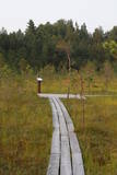
In 2006, a wooden pathway was installed across the Planči swamp – 500m long, which means that the visitor will spend around 20 minutes there. This is probably the only nature trail in Latvia for which there are plans to post information in Braille for people with impaired vision.
|
|
|
|
Teirumnīku purvs ir latvijas lielākā iekšzemes mitrāja - dabas lieguma "Lubāna mitrājs" sastāvdaļa, kas meklējams dienvidaustrumos no Lubāna ezera. |
|
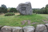 |
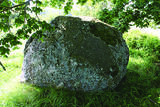
Pāvilostā ir trīs parki. Pāvilostas centrā (pie kultūras nama) atrodas Piecdesmitgades parks, kuru 1929. g. iekopa skolotājs un novadpētnieks Ernests Šneiders. Vienu ozolu tajā esot iestādījis Latvijas Valsts prezidents Gustavs Zemgals. Simtgades parks ar piemiņas akmeņiem tapa Sakas labajā krastā jau kā turpinājums iesāktajam. Vecākais no Pāvilostas parkiem - Upesmuižas parks (19. gs.) atrodas tuvu Liepājas – Ventspils šosejai. Upesmuižas pils nav saglabājusies (nodedzināta 1905. g.). Parkā apskatāms sens akmens sols (perimetrs 5,55 m) un Upesmuižas parka Lielais akmens. Domājams, tas ir kultakmens. |
|
 |
Dabas liegumā ietilpst divi aizauguši ezeri ar grūti pieejamiem krastiem - Lielais un Mazais Asūnes ezers, kas atrodas dienvidos no Asūnes ciema. Abus ezerus var vērot, atrodoties ārpus lieguma teritorijas - no blakus esošo pauguru augstākajām daļām, kas atrodas austrumos no abiem ezeriem. Ja līdzi būs paņemts tālskatis, iespējams, izdosies iztālēm novērot šeit esošās aizsargājamās putnu sugas, piemēram, melno zīriņu. |
|
 |
This tower is on the shores of the ancient Litorine Sea, with a lovely view of the unique seashore here – complete with small bays and capes. It is part of the Kaltene nature trail, which is around one kilometre long. The location is of particular interest during spring or autumn migration of birds. Two other bird-watching platforms are nearby.
|
|
 |
The great Black Plague rock, which has engraved text that can still be seen
to a certain extent – it tells future generations about the local pastor who died
from the plague, about how the parsonage was established at Sīkrags and then
moved to Mazirbe. The rock is also a monument to six pastors of the nearby
congregations. All the three stones tell about the horrors of the Black Plague in
1710, the texts have been engraved during the parson Peterson in 1711-1734.
|
|
 |
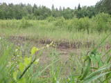
The small Andrupene swamp is found to the North of the Andrupene Farm Museum in a deep area between hillocks. It is a high-type swamp with an open central part, and it is 130 m long and 120 m wide. There are stands of white alder alongside the swamp. In 2009, the administrators of the Rāzna National Park restored a wooden educational pathway that had been established originally by the Andrupene Elementary School. Today there are stairs, a viewing platform, wooden pathways, and information stands. |
|
|
|
Atrodas Burtnieka ezera austrumu krastā – uz ezera poldera dambja. Pavasara un rudens migrāciju laikā – laba putnu vērošanas vieta. Putni redzami ne tikai ezera piekrastē, bet arī poldera mitrajās pļavās. |
|
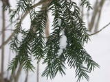 |
The forest covered area formed to protect tort protected plant species as yew-tree etc. Territory is not suitable for visitors as visitor without environmental knowledge will see “regular” forest.
|
|


